Wednesday: Idalia arrives

Hurricane Idalia, which as of this writing was a strong Category 2 hurricane with 100 MPH maximum winds, will make landfall as a major hurricane in Florida later Tuesday or early Wednesday. From there, Idalia will turn more northeast, bringing heavy rain, gusty winds, coastal and freshwater flooding, and the risk for a tornado or two within rain bands to the area later Wednesday into early Thursday morning. Trends have been for the storm to track a little more inland of the coast than we’ve seen forecasted in the past day or so, and there is pretty good agreement that this will be the case, expanding the heavy rain threat further inland along with the tornado threat in the evening. Here’s a full rundown of what to expect.
Tropical storm conditions to begin Wednesday afternoon
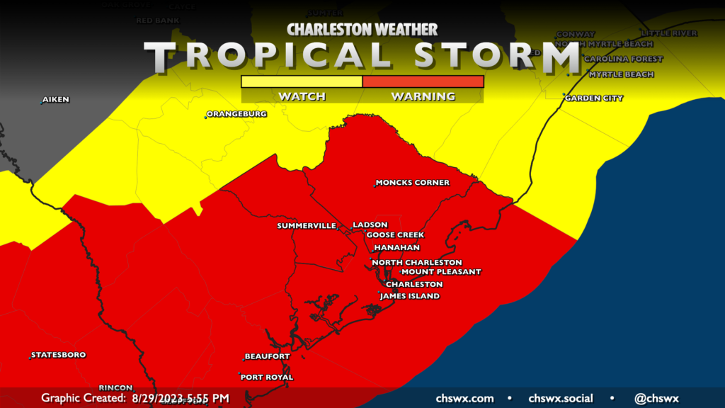
Much of the area is under a Tropical Storm Warning as of this writing Tuesday evening. This means that tropical storm conditions are expected within the watch area within 36 hours, including winds 39-73 MPH. While sustained winds shouldn’t reach quite that high further inland, gusts within rain bands could certainly land in that range, prompting NWS to expand the Tropical Storm Warning into Dorchester County. Expect rain bands to begin to kick up as we head into Wednesday afternoon, though some rain can’t be ruled out in the morning, either. Certainly the greatest risk of tropical storm-force winds becoming sustained will be in the coastal waters as well as the beaches, and this is where the greatest power outage risk will reside as well.
Storm surge: 2-4′ reasonable worst-case scenario; major coastal flooding expected
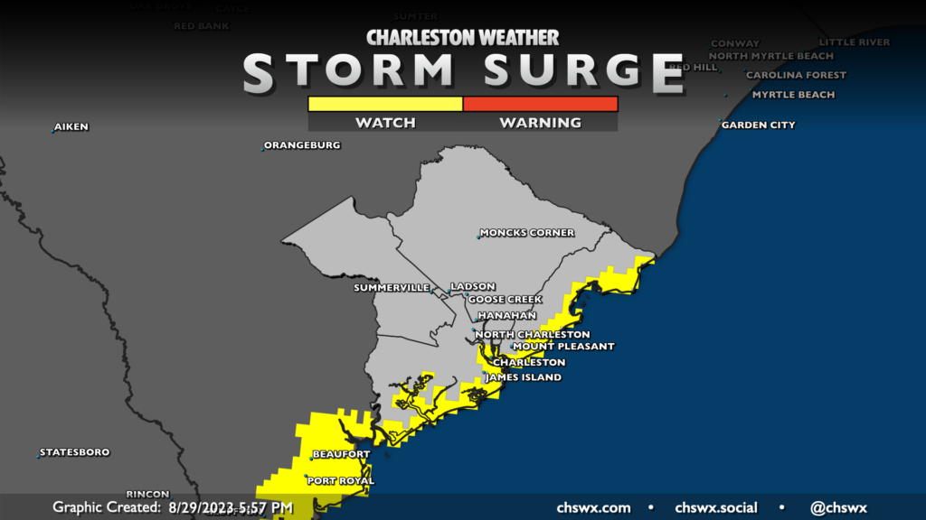
Storm surge is quite a concern with this system as well, given that it will be arriving around high tide during a full moon phase at perigee (closest pass to the Earth). Tides were already going to be high on Wednesday evening, but with the strong onshore winds from Idalia, expect major coastal flooding to occur around this tide. The current total water forecast (as of this writing) in Charleston Harbor is 8.3′, well into major flood stage and approaching a top-15 tide on record at the harbor. Wobbles in the track or changes in forward speed will have impacts on this forecast, and it seems like a good bet this will change a couple more times before it’s all said and done. However, minutia aside: significant flooding will be possible in downtown Charleston, and it may be fairly long in duration especially if heavy rain moves through ahead of high tide. There are a lot of variables here, but be prepared to stay put where you are starting Wednesday afternoon.
Heavy rain and freshwater flooding: 4-8″ in spots, particularly inland
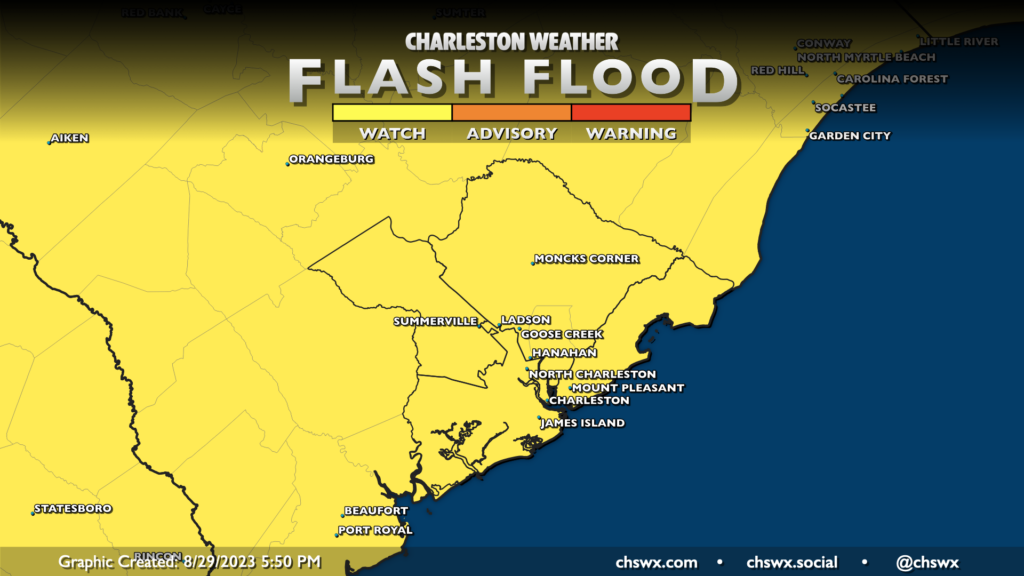
A Flood Watch is in effect across the Lowcountry — and, for that matter, much of the state — as Idalia’s rain bands traverse the area with very heavy rain possible. Idalia’s main rain shield is timed to come through in the afternoon and evening hours, and this is where the best risk for flash flooding will come from. Interestingly, given the slightly more inland track currently forecasted, we should see the best risk for the heaviest rain (amounts potentially approaching 8″ in spots) generally inland of 17-A. However, any track wobbles to the east bring this heavier rain shield toward the coast.

This seemingly counterintuitive rainfall forecast is a function of Idalia’s moisture interacting with an approaching front as well as some dry air beginning to infiltrate the circulation after landfall. Again, shifts in the track could increase the rain threat significantly further east, hence the ongoing Flood Watch. However, it’s somewhat hopeful that we may miss the worst of the rain at the coast, keeping coastal flood impacts more limited to salt water vs. freshwater flooding.
Tornadoes possible Wednesday afternoon and evening ahead and east of Idalia’s center

Tornadoes will be a concern for Idalia given that we will be on the north side of the circulation for a good bit of the day Wednesday. Additionally, with a slightly more inland track in the forecast, that too will serve to push the tornado threat a little further inland. The risk for tornadoes will increase as we head into Wednesday afternoon and evening. It’s possible, depending on the forward speed of the system, that a tornado threat could linger into Wednesday night/early Thursday morning as well. Thus, it’s important that you have ways to receive weather warnings that can wake you. Tropical tornadoes typically spin up with little notice and are short-lived. If you get a warning, take shelter quickly in an interior room on the lowest floor, putting as many walls between you and the outside as possible.
What to do tonight
Tonight, it’s time to finish putting loose items away, ensuring flashlights and weather radios have fresh batteries and are working properly, and getting ready to just hunker down Wednesday night. At this point, we’re well beyond the time to obsess over spaghetti models and the like — it’s now just time to get ready to meet Idalia. We’re going to be just fine, by the way — this is far from anything we can’t handle. I’m sure some of you will find some thunderstorms from this past summer more intense, and that is fine by me.
Fortunately, the worst of the weather should be relatively short-lived. By Thursday, we should see improving conditions with winds coming down throughout the day (though some showers could persist). Temperatures on Thursday will actually be quite comfortable, and Friday looks downright fantastic with highs in the low 80s and plenty of sunshine. So, hang in there, because there will be a good payoff post-Idalia.
Follow my Charleston Weather updates on Mastodon, Bluesky, Instagram, Facebook, or directly in a feed reader. Do you like what you see here? Please consider supporting my independent, hype-averse weather journalism and become a supporter on Patreon for a broader look at all things #chswx!