Friday & the weekend: Gusty, showery Friday but a better weekend
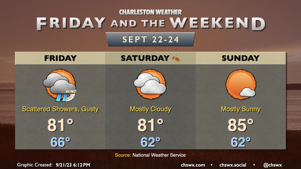
The weather for Friday and at least the first part of the weekend will be dictated in part by Potential Tropical Cyclone Sixteen, which is forecast to become a tropical storm — probably named Ophelia unless an Atlantic wave develops faster than forecast — as it approaches the NC Outer Banks this weekend. We will stay well on the western periphery of the storm and only feel the occasional shower on Friday, with a gusty breeze for most of us. It will be a rough go at the beaches — probably not the best day to go with gusty winds, high surf, rip currents, and some afternoon coastal flooding around the 1:45 PM high tide. Erosion is certainly not out of the question as well. Highs on Friday top out in the low 80s.
Showers depart by Saturday as maybe-Ophelia moves northward away from us. We start the day in the low 60s with temperatures heading into the low 80s once again under mostly cloudy skies. We should see some breaks in the clouds develop particularly as we get later into the day, though. Winds will remain somewhat breezy, but not to the degree we’ll see Friday.
Sunday is the pick day of the weekend as far as outside stuff goes; lows in the low 60s give way to highs in the mid-80s under mostly sunny skies. Another plus to Sunday: Winds will have tapered off considerably, too, as maybe-Ophelia loses tropical characteristics around the Delmarva Peninsula.
Potential Tropical Cyclone Sixteen likely to become Ophelia by the weekend, bringing surge to NC and the Mid-Atlantic states
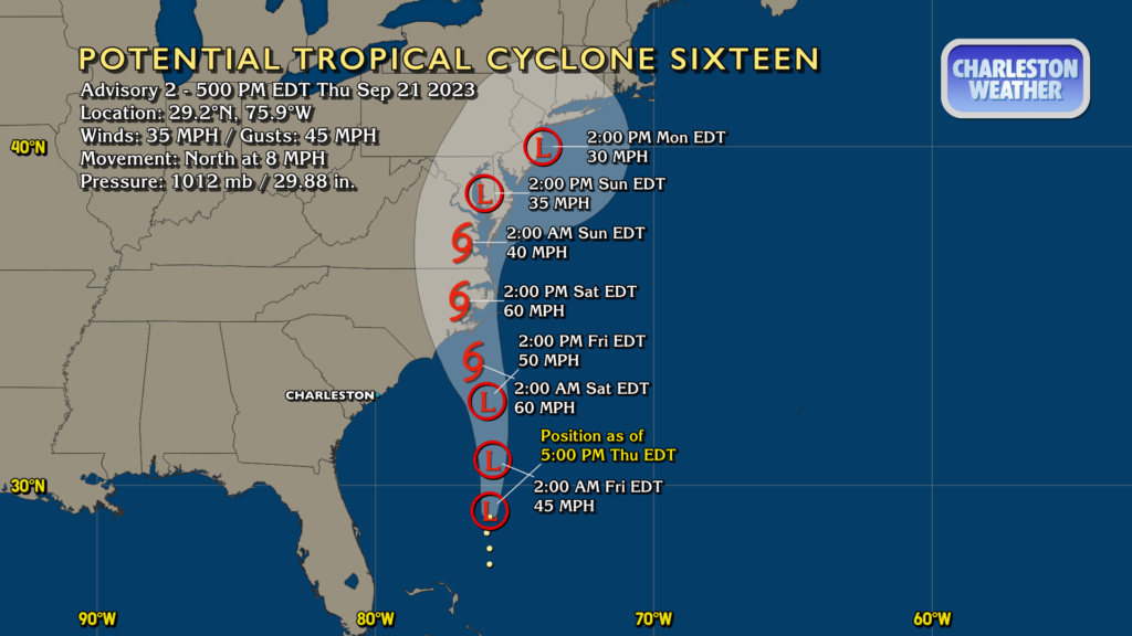
Potential Tropical Cyclone Sixteen — not yet a tropical cyclone, but classified so that NHC can hoist Tropical Storm Warnings along the NC and VA coasts — has 35 MPH winds and is moving north at 8 MPH. It’s well off our shores and should stay that way, with largely minimal impacts here aside from the aforementioned winds, surf, and rip currents. It will bring storm surge and heavy rains to North Carolina and Virginia tomorrow through the weekend, so if you’ve got Outer Banks plans that aren’t a Netflix show, it might not be the most fun time you’ve ever had.
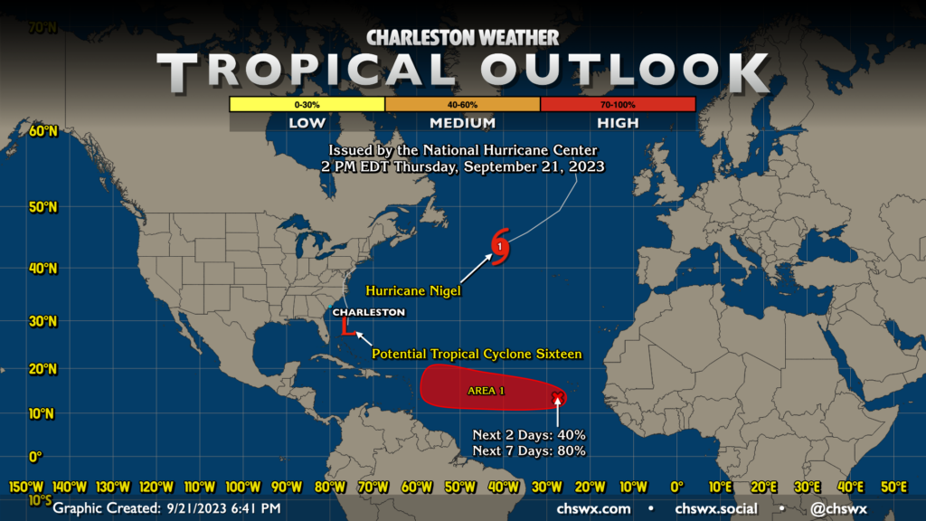
Elsewhere in the tropics, Nigel is on its way out as a tropical cyclone, making an extratropical transition as it continues to grow and accelerate northeastward. Finally, an area west-southwest of the Cabo Verde Islands is a good bet to develop into a tropical cyclone within the next seven days. The National Hurricane Center has tagged it as Invest 90L. This could become an issue for the Lesser Antilles next week. Thereafter, the picture gets fuzzier, but the initial returns from guidance largely favor a recurvature scenario. We’ve got plenty of time to keep an eye on things, so no worries about 90L for now.
Follow my Charleston Weather updates on Mastodon, Bluesky, Instagram, Facebook, or directly in a feed reader. Do you like what you see here? Please consider supporting my independent, hype-averse weather journalism and become a supporter on Patreon for a broader look at all things #chswx!