The week ahead: Big shot of cool air for mid-week; very little, if any, rain in sight
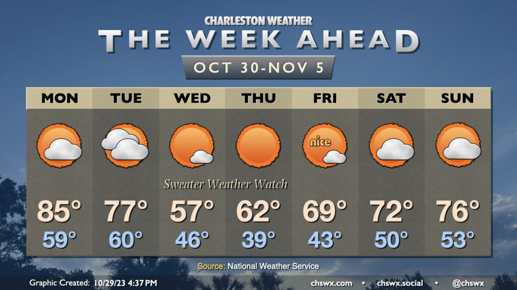
The week ahead will feature the strongest cold snap of the season thus far sandwiched between a warm start and a warm finish. It’s a classic “shorts then sweaters” week of fall weather in the Lowcountry as a strong front moves by late on Halloween.
First, though, the shorts portion. Another record high is possible on Monday after we tied the daily record on Sunday. Monday’s record high is 85° set in 1949, and the current NWS forecast is that we tie that record. We’ll see a little bit more in the way of clouds, but that’s about it.
Tuesday will start out as another warm day, but we should see cooler and drier air beginning to filter into the area as the day goes on as the cold front gets by. The frontal passage should be mostly dry, but a few showers can’t be ruled out the further north you are. We’ll otherwise see an uptick in cloud cover as the front gets by. The current forecast shows highs in the mid-70s, but it is possible that may run a little cooler depending on the timing of the front.
Wednesday will feel a lot different. Breezy northerly winds will bring in plenty of cool and dry air. The low of 46° may feel closer to 39° thanks to the wind chill. Dewpoints will fall into the 20s and high temperatures may not break 60° for the first time since April 8, when the high only maxed out at 56°. Expect very few, if any, clouds.
Thursday will likely be the first day this season with widespread upper 30s away from the coast. Cool advection will begin to slow down, though, and the airmass will start to moderate. Still, Thursday’s another solid sweater weather day with highs in the low 60s under sunny skies.
As we head into Friday and the weekend, highs continue to moderate from the upper 60s on Friday to the mid-70s by Sunday. Low temperatures will climb back into the low 50s for the weekend as well. There’s still no sign of any rainfall, with mostly sunny to partly cloudy skies expected.
Coastal flooding concerns continue
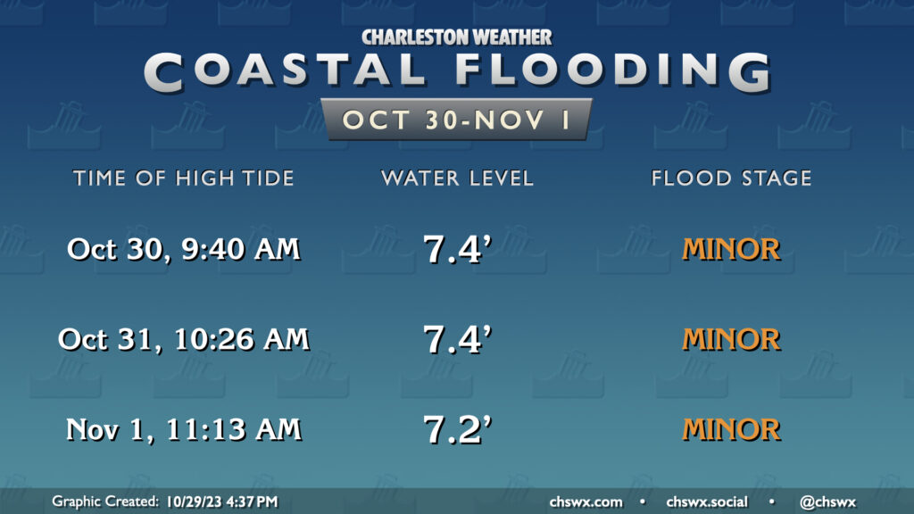
Coastal flooding will continue to be an issue with the morning high tides as lingering astronomical effects from the recent full moon and favorable winds help drive tidal departures. Minor coastal flooding is generally expected, though a bump up in the departures could send us into moderate flood stage especially Monday and Tuesday. Monday’s highest tide will be around 9:40 AM, while Tuesday’s will be just shy of 10:30 AM. Be ready for the potential to have to reroute around flooded roads.
Tropics: A couple areas to watch, but nothing to be concerned over
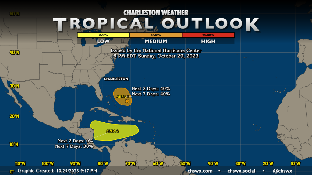
The National Hurricane Center is monitoring two areas for possible development over the next few days. The first, northeast of the Bahamas, is running out of time to organize if it is ever going to. Hurricane Hunters visited this disturbance earlier today and found no real organized surface circulation. Shear is going to ramp up over this area soon, and with an incoming cold front to follow, the chance for it to get going is diminishing.
The second area is across the southern Caribbean. Models continue to hint at some sort of low pressure trying to form here over the next few days, and there’s a chance that could turn tropical. However, nothing has gotten going as of yet, and it remains to be seen how this evolves. All in all, though, it’s nothing for us to really get worked up about right now (if ever).
Follow my Charleston Weather updates on Mastodon, Bluesky, Instagram, Facebook, or directly in a feed reader. Do you like what you see here? Please consider supporting my independent, hype-averse weather journalism and become a supporter on Patreon for a broader look at all things #chswx!