Friday & the weekend: Warming up, with a showery and windy Sunday ahead
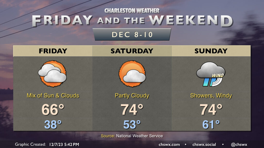
Another round of chilly weather is expected overnight Thursday into Friday. We’ll wake up to temperatures in the upper 30s Friday morning, but high pressure slipping offshore will allow temperatures to warm up to the mid-60s in the afternoon under a mix of sun and clouds. Overall, Friday looks pretty good.
The warming trend continues into the weekend. Saturday is the pick day of the weekend for outdoor activities, and it really isn’t close as a front gets through Sunday. It starts significantly warmer than Friday did, with lows in the low to mid-50s expected. Highs will top out in the mid-70s under generally partly cloudy skies. This will be the last warm and quiet weather day for at least a few days, so try to take advantage!
The weather changes fairly quickly overnight Saturday into Sunday as a strong storm system’s cold front drives toward the area. Sunday gets off to another unseasonably warm start, with lows in the low 60s expected. Showers may be firing off first thing Sunday, but the main band of rain associated with the front looks to arrive later in the afternoon and evening. Wind will be another factor, with gusts upwards of 30 MPH appearing possible at times, even outside of storms. The risk for severe weather is quite low, owing to the minimal available instability that’s expected despite no shortage of bulk wind shear. Still, some thunder is possible, and if additional instability can kick up, a strong to damaging wind gust or two is not out of the question. More fine-tuning of the forecast will occur, but generally speaking, Sunday just doesn’t look promising to be outside.