Friday & the weekend: Turning unsettled as a strong coastal storm affects the area
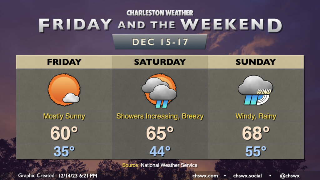
Well, first off, this is not going to be the best weekend of weather ever, especially as we get into Sunday as a now fairly well-discussed nor’easter heads up the coast. So, if you can get some time outside on Friday, do that. It’ll be a chilly start, with lows in the mid-30s and perhaps even a tick or two close to freezing further inland. Temperatures will then warm to around 60° under mostly sunny skies.
There will be a risk for minor coastal flooding with high tide around 9:28am. Water levels should peak just around 7′, and this should be enough to cause a few problems on Lockwood as well as around Fishburne and Hagood. Widespread issues are not expected, though.
Saturday: Showers arrive, winds start to kick up
Clouds will be on the increase throughout Saturday as the atmosphere begins to get juiced up with plenty of Gulf moisture ahead of developing low pressure. We could see some showers as early as late morning/early afternoon, but the best risk of rain will arrive later in the afternoon through the evening hours. Temperatures will be on the warm side of normal, generally topping out in the mid-60s despite showers in the area.
Expect wind to kick up as the afternoon and evening progresses as well, with gusts 20-30 MPH becoming common as low pressure draws closer. Higher gusts are expected at the beaches and on bridges and overpasses, so keep this in mind if bridges are part of your Saturday evening travel.
Sunday: Storm peaks; heavy rain, gusty winds, coastal flooding
It’ll likely rain all night Saturday; this will continue into Sunday as winds continue to kick up, especially near the coast. Wind speeds 20-25 MPH look to be common, with gusts perhaps approaching 40+ MPH, with the breeziest conditions once again at the beaches. I wouldn’t be surprised to see several 50 MPH readings from some of the WeatherFlow mesonet stations Sunday, so be ready for isolated power outages and tough travel on bridges once again.
Showers with periods of heavy rain will continue to spiral onshore as well, particularly in the morning. Some spots could see upwards of 2-3″ of rain before it’s all said and done — thankfully not all occurring in an hour or two, so the risk for freshwater flooding seems to be fairly low. Depending on the track and forward speed of the low — still a couple things that the models have some disagreement on — we may see showers begin to abate some as we head into Sunday afternoon and evening.
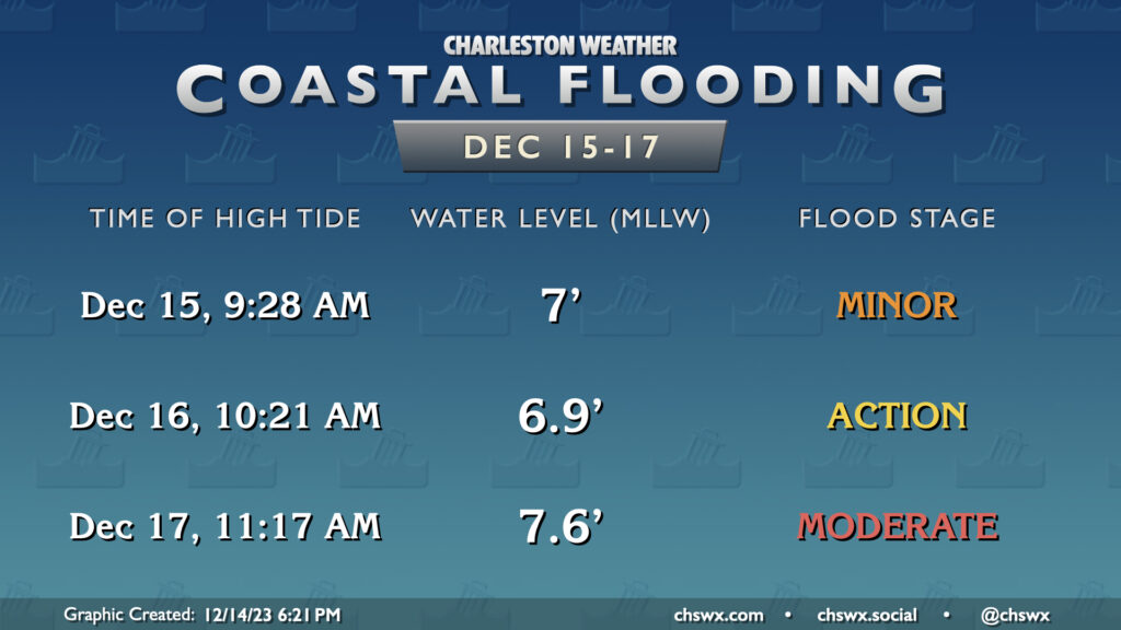
Coastal flooding could be quite impactful late Sunday morning into early afternoon. High tide around 11:17am is currently forecast to peak in moderate flood stage around 7.6′ as strong northeasterly winds pile up the water and drive it ashore. It isn’t out of the question to see this forecast revised further upward as trends become more apparent, too, with major flooding certainly a possibility, so stay tuned.
As always, stay up to date for additional forecast tweaks as we get into tomorrow, and be ready to just write Sunday off as a day to stay inside.
Follow my Charleston Weather updates on Mastodon, Bluesky, Instagram, Facebook, or directly in a feed reader. Do you like what you see here? Please consider supporting my independent, hype-averse weather journalism and become a supporter on Patreon for a broader look at all things #chswx!