Thursday: Windy day with morning coastal flooding and a chill in the air
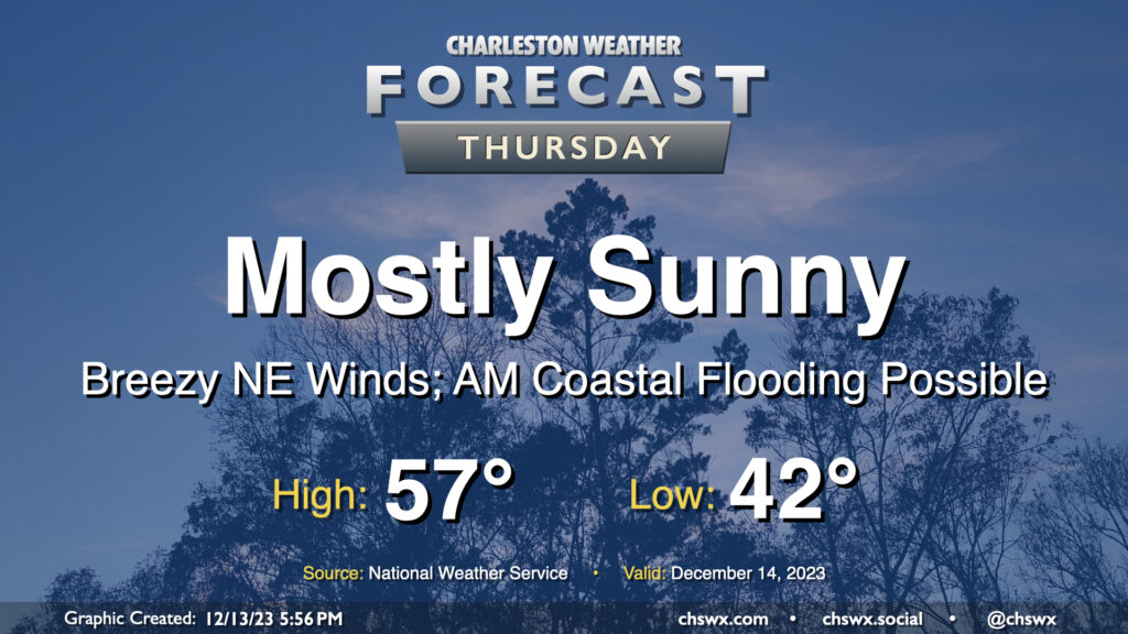
Reinforcing strong high pressure building into the area on Thursday keeps our weather generally cool and quiet, though winds will be blustery and there will be a coastal flooding risk in the morning.
Lows will dip only to the low 40s owing to breezy conditions restricting better radiational cooling. However, cool air pushing in from the northeast will keep highs capped to the upper 50s despite plenty of sunshine. Combine that with an increasingly stiff breeze — 15-20 MPH in the metro, with higher gusts — and you’ll be glad for a jacket with some wind-breaking capability. At least the sun will be out, and the sky should be largely unmarred by any cloud cover.
High tide around 8:37am will get high enough for minor to perhaps moderate coastal flooding smack dab in the middle of the commute. Be ready for possible road closures if downtown is in your commute plans. I’d also be cautious around Long Point Road near Snee Farm as water levels could approach thresholds to flood that road as well. Coastal flooding will remain a concern for the next few mornings, especially as we get into the weekend.
Friday & the weekend: Quiet start, but a nor’easter could spoil Sunday
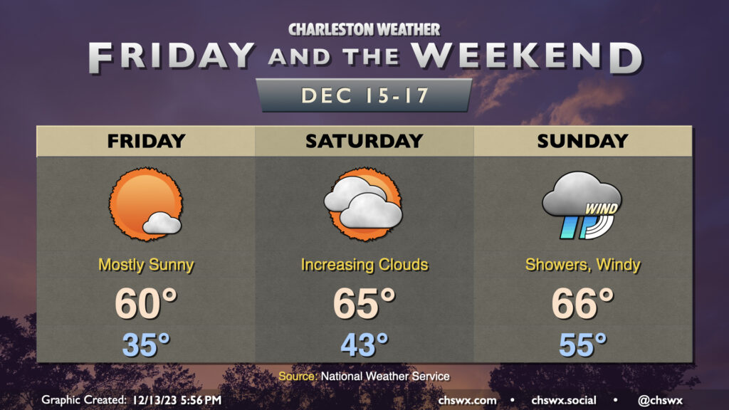
Quiet weather continues for a couple more days before a nor’easter potentially affects the area on Sunday. Friday will get off to another chilly mid-30s start, warming to around 60° in the afternoon under mostly sunny skies. It won’t be quite as breezy as Thursday is expected to be, but some stronger gusts remain a concern, and minor coastal flooding will be possible with the 9:28am high tide.
Cloud cover begins to tick up Saturday as low pressure organizes in the Gulf. Warmer and more humid air will also gradually start to set in as well, pushing highs to the mid-60s on Saturday afternoon. It remains to be seen whether we’ll see rain on Saturday; there is a chance that a few showers could work into the area later in the day into Saturday evening, but the better risk for rain arrives Sunday as the low pressure system makes its closest approach to the Lowcountry. Strong, gusty winds will be possible, particularly near the coast, along with showers — some heavy at times — and a continued risk for coastal flooding near high tide. There are still discrepancies between the global models with the track this storm should take. The GFS is a little faster and further inland, potentially funneling in some instability that could lead to a few thunderstorms. The ECMWF (Euro) has the low skirting our coast, keeping the instability offshore but still socking us in with a fair bit of rain. Right now, this appears to be the most favored solution. Showers could hang around into Monday in either case. Stay tuned to forecast updates as things continue to evolve with this storm.
Follow my Charleston Weather updates on Mastodon, Bluesky, Instagram, Facebook, or directly in a feed reader. Do you like what you see here? Please consider supporting my independent, hype-averse weather journalism and become a supporter on Patreon for a broader look at all things #chswx!