Flooding possible Tuesday morning; drying out the rest of the week

Wet weather continues overnight Christmas into Tuesday, as showers and thunderstorms with occasional patches of heavy rain continue to move through the area. Flooding will be a concern particularly in the morning as high tide around 7:15am, which should exceed flood stage in Charleston Harbor, could coincide with periods of heavy rain. This combination may produce more widespread flooding than a typical tidal event, making roads impassable and causing them to close. Be ready to route around flooded roads and for delays — perhaps significant — if downtown is in your travel plans Tuesday morning.
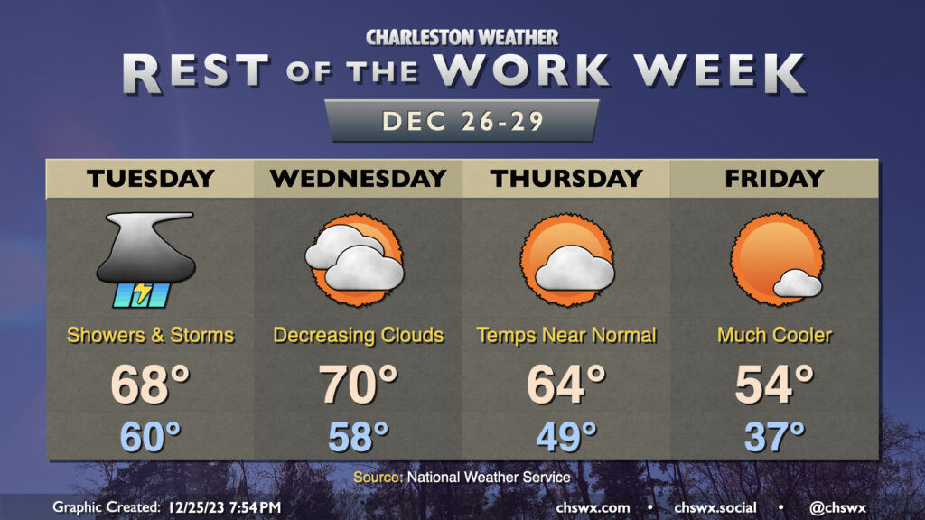
Showers and thunderstorms look to continue for a fair bit of Tuesday. We should start to see rain begin to scatter out as we head into the evening, though lingering showers will be possible overnight. Temperatures will be rather mild — the low of 60° is pretty close to the normal high for December 26. We’ll warm to the upper 60s, limited mostly by rain in the area.
Cloud cover will break up some on Wednesday as some drier air moves in. It’ll be another warm day, with lows in the upper 50s yielding to highs around 70° in the afternoon. Some cooler air begins to work into the area on Thursday as cloud cover ticks down, with highs running about 5° or so cooler than Wednesday. Then, a cold front later Thursday will usher in even cooler air, knocking Friday’s temperatures well below normal. Expect lows in the mid-30s to yield to highs only in the mid-50s in the afternoon despite mostly sunny skies.
New Year’s weekend: Cool but quiet

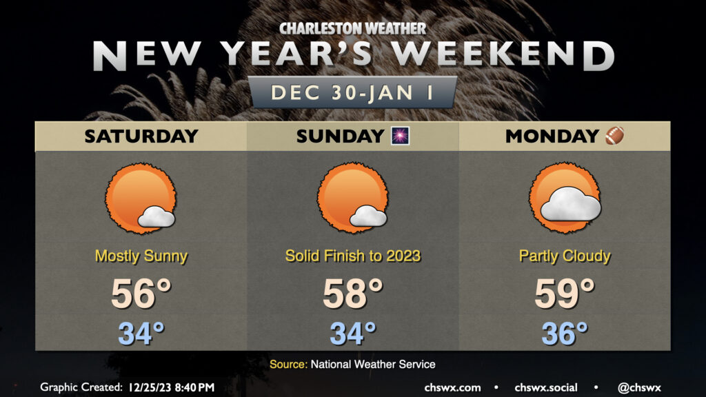
Cooler-than-normal temperatures and quiet conditions will continue into the final weekend of 2023 and as we welcome 2024. Saturday and Sunday will both get off to chilly starts, with temperatures in the mid-30s in the metro and perhaps around freezing further inland. Highs on Saturday top out in the mid-50s once again, but a subtle warming trend will have highs approaching 60° by New Year’s Day.
Follow my Charleston Weather updates on Mastodon, Bluesky, Instagram, Facebook, or directly in a feed reader. Do you like what you see here? Please consider supporting my independent, hype-averse weather journalism and become a supporter on Patreon for a broader look at all things #chswx!