The week ahead: All eyes on Tuesday’s severe potential
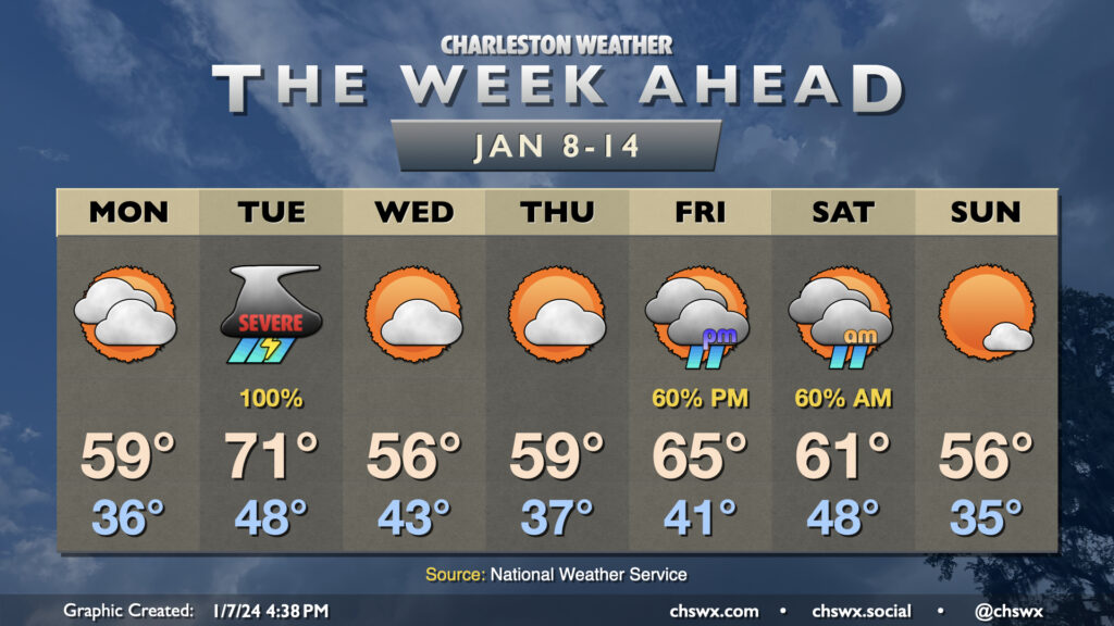
The active weather pattern we’ve found ourselves in for the start of the year continues this week as we’ll see at least two storm systems visit the area, with quiet and generally cool weather days interspersed between them.
Monday will feature increasing clouds and a steady east to northeast breeze as high pressure wedges southward. We start the day in the mid-30s and warm to around 60° in the afternoon with clouds steadily increasing ahead of Tuesday’s storm system. Late Monday, a warm front will lift north of the area, which may bring some scattered showers along with it, but we should get much of the daylight hours, if not all of them, in rain-free.
Tuesday’s severe weather threat
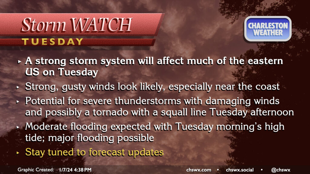
Confidence is increasing that Tuesday will feature some fairly high-impact weather as high pressure will be shoved out of the way of a deepening low pressure system making its way toward the Great Lakes, dragging a front across the area late in the day.
Coastal flooding: We start the day with a high tide that could run well into moderate flood stage and may even push into major flood thanks to increasing southeasterly winds. Rain showers could be in the area, but the good news is that the heaviest rain associated with the squall line will miss this tide. Even still, travel disruptions could occur up to a few hours after the 5:57am high tide, so be alert for your morning commute.
Strong, gusty winds: From there, expect winds to steadily increase outside of thunderstorms as the pressure gradient between the deepening low to the northwest and the flattening high pressure to the northeast pinches big-time. Sustained winds 30-40 MPH are a distinct possibility across the metro area, with the highest wind speeds near the coast. Gusts could approach 50 MPH at times, with maybe even higher gusts possible on bridges and overpasses, particularly near the coast. It’s conceivable we may be dealing with downed trees and power outages regardless of what storms end up doing; be prepared for this possibility.
Severe thunderstorms: Models are in excellent agreement that some sort of squall line feature will be approaching the area in the afternoon and evening hours. Within this squall line, individual cells could easily pull down 60+ MPH gusts causing localized areas of wind damage. Low-level wind shear is impressive as well, and this could easily induce some rotation within the leading edge of the line, so a spin-up tornado or two will be possible as well.
The major question will be how much instability can develop, and this will be the primary condition for severe weather Tuesday. Overall, guidance is fairly tame in the instability department, but even marginal instability could be maximized by the available shear. We’ll certainly be rooting for rain throughout the day (as most models advertise) as this will help keep that instability down, putting a governor on the overall severe threat. If slots of clearing can develop, additional instability could increase the severe threat, but that outcome appears rather unlikely right now.
The important thing to remember: Not everyone will see severe weather on Tuesday. With a little luck, we won’t see any at all. However, the synoptic setup is such that the ringing the alarm on severe potential is warranted. Stay in touch with weather updates over the next couple days as the forecast is refined.
Tuesday night through Thursday: Generally quiet with slightly below-normal temperatures
Once the front swings through Tuesday night, we’ll cool off a bit. Wednesday morning starts in the low 40s and warms only to the mid-50s with generally partly cloudy skies. Thursday will be similar, though we’ll start the day in the mid-to-upper 30s. Expect highs near 60° Thursday afternoon.
Next storm system on Friday; weekend not a washout, though
The next storm system will affect the area later Friday into early Saturday. Early indications are that this storm system could be on the strong side once again, with gusty winds and heavy rain the main concerns. The good news is that the current forecast has it departing Saturday afternoon, keeping our Sunday relatively intact, weather-wise. However, this far out, timings can change, so stay tuned for updates.
Follow my Charleston Weather updates on Mastodon, Bluesky, Instagram, Facebook, or directly in a feed reader. Do you like what you see here? Please consider supporting my independent, hype-averse weather journalism and become a supporter on Patreon for a broader look at all things #chswx!