Tuesday: Multiple weather hazards expected with an abnormally strong storm system
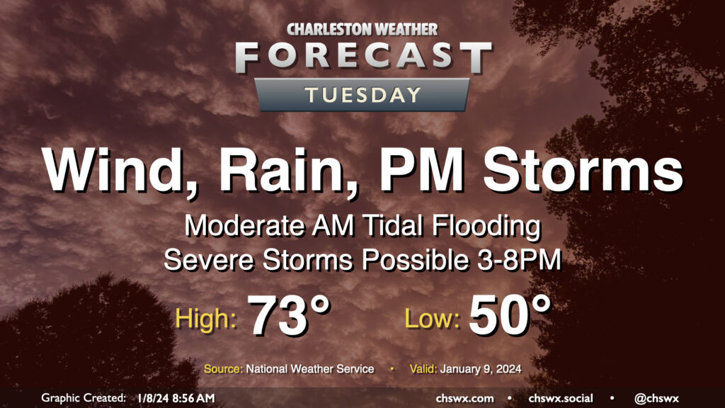
An unusually potent storm system will affect the area on Tuesday, bringing strong, gusty non-thunderstorm winds, some tidal flooding in the morning, and a squall line in the afternoon and early evening that could bring a swath of damaging winds and maybe a few tornadoes on its leading edge.
What to expect
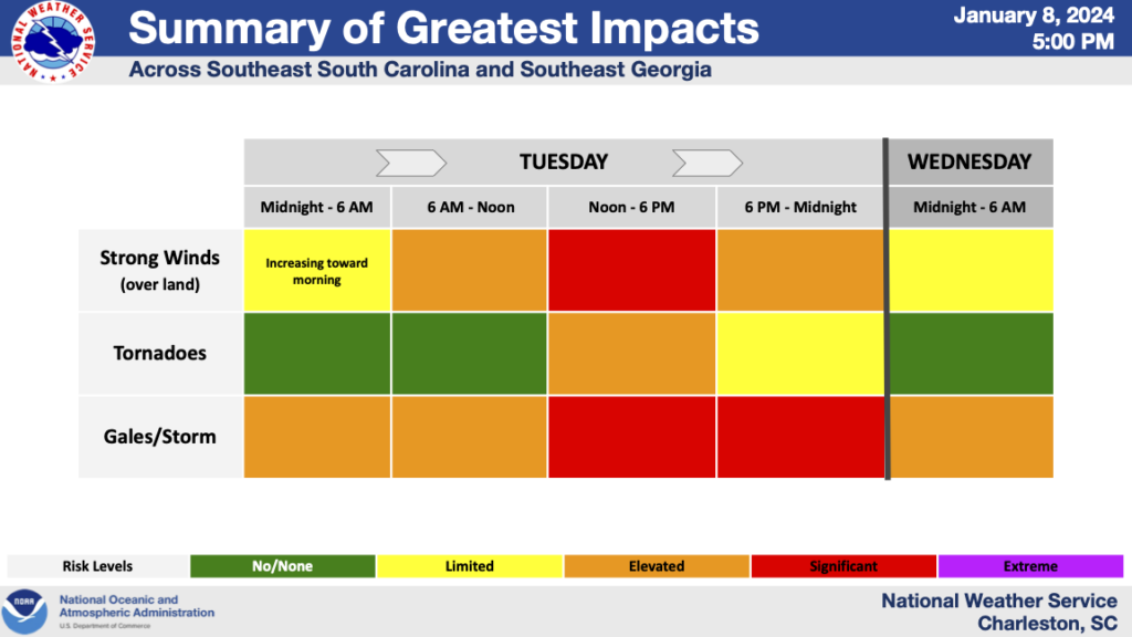
Winds: A warm front will lift across the area overnight Monday/early Tuesday, bringing some showers with it, but also turning on the heat pump. Temperatures will likely be in the low 60s when we wake up, and winds will be coming up to around 20 MPH with gusts 30-35 MPH. From there, winds will continue to increase as the low level jet strengthens. By midday, sustained winds upwards of 25-35 MPH could be quite common, with gusts 40-50 MPH a distinct possibility. Gusts could approach 60 MPH in the coastal corridor, and it’s for this reason that the National Weather Service has issued a very rare High Wind Warning for Charleston and tidal Berkeley counties that will be effective from 10am-10pm. (The last High Wind Warning was on December 21, 2012, for Berkeley County.) Elsewhere in Dorchester and inland Berkeley counties, a Wind Advisory goes into effect at 6am and will last through 10pm.
It’s very conceivable that non-thunderstorm wind damage may cause power outages and downed trees ahead of the expected squall line and its associated severe weather in the afternoon. Keep phones charged and make sure you have fresh batteries in the weather radio just in case.
Travel over bridges and overpasses will be complicated by the strong winds as well. High-profile vehicles will have particular issues, and it wouldn’t shock me if we saw a couple overturned tractor-trailers tomorrow due to the winds. If you must travel — many places have decided to close tomorrow out of an abundance of caution — hold on tight if you are headed across the bridges.
One more note on bridges: They don’t close due to winds. However, when sustained winds climb over 35 MPH, we start to see public safety agencies pull back from trying to travel over them. In essence, if you get in trouble up there with the winds roaring, you run the risk of being on your own.
Temperatures: Plentiful warm and moist air will be pumping into the area throughout the day. Expect temperatures to top out in the low 70s in the early afternoon despite what should hopefully be a fairly solid cloud canopy. Peeks of sun are not our friend on Tuesday; any sunshine could send temperatures up quickly, further destabilizing the atmosphere and also increasing the risk of damaging non-thunderstorm wind gusts due to improved mixing of the air into the absolutely screaming low-level jet (70-80 knots).
Tidal flooding: Moderate coastal flooding is expected in the morning as water levels in Charleston Harbor look to peak between 7.6-7.8′ around the 5:57am high tide. We could see the salt water stick around for a bit in spots as the tide will likely be slow to go out due to the very strong and persistent south to southeasterly wind. There will be rain in the area around high tide, but indications are that it should not be heavy enough to further exacerbate flooding issues downtown. The heaviest rain of the day will miss high tide, and we should also see peak “surge” with the stronger winds around low tide. Bottom line is that this does not look like a repeat of December 17, but I would be ready for travel problems and road closures regardless.
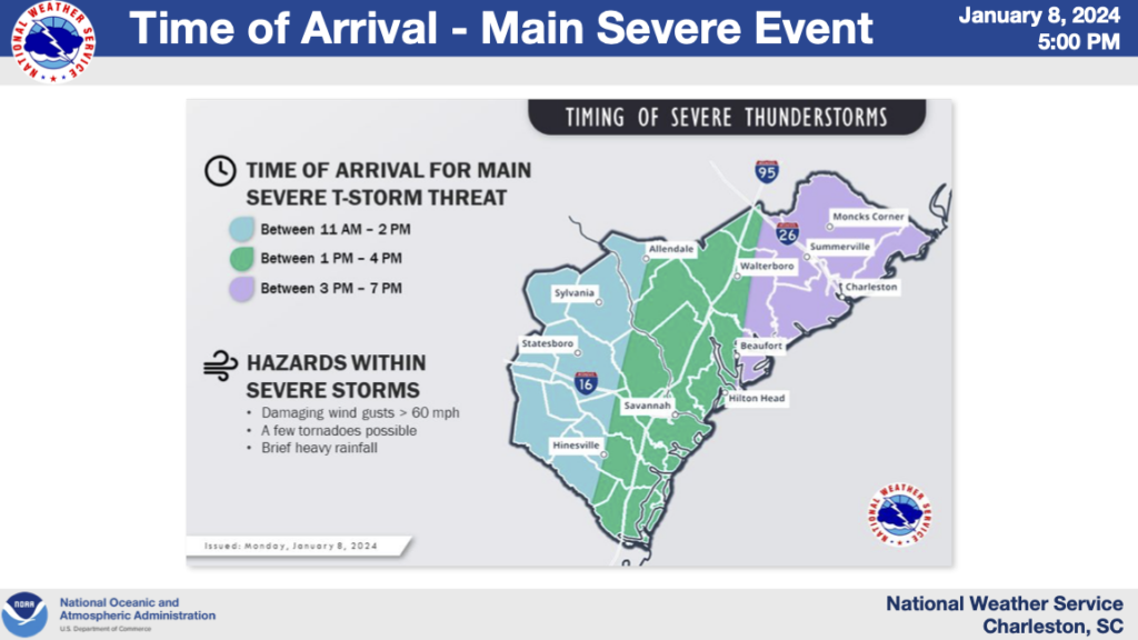
Severe weather: A squall line is expected to be marching across the Southeast throughout the day Tuesday, and should arrive in our neck of the woods later in the afternoon into the early evening. Timing these squall lines even 12 hours out can be very difficult, but the current thinking from NWS is that the line arrives in the western reaches of the Tri-County area roughly 1-4 PM and progresses to the coast through early evening. This line of thunderstorms may be capable of producing swaths of damaging winds; gusts to 70 MPH are not out of the question. Given very favorable shear profiles, it is possible that there could be tornadoes embedded in the leading edge of the line as well.
Caveats: The major question mark for severe weather is how much instability can develop across the area. Climatologically, many of these cool season severe weather setups are derailed by a lack of surface-based instability, which is a necessary ingredient particularly for tornado formation. However, given the extreme nature of the expected wind fields and shear, we might not need much in the way of instability to get severe weather. Models do develop a plume of instability across the area ahead of the line to various degrees. I’m leaning a little toward the lower end, barring unexpected breaks in the clouds, because of the potential for some stabilizing influences from the cool shelf waters from the Atlantic, which have more often than not broken up a lot of squall lines as they march toward the coast. However, the wind fields and overall energetic nature of the storm system as a whole may make the cool shelf waters (the Charleston Harbor water temperature is 54°) a moot point.
Another thing that could lower the overall threat from this system would be a faster-than-expected squall line passage. We would still see a period of strong, gusty non-thunderstorm winds, and there would still be a risk for severe weather, but there would be less residence time for those winds, not to mention less time for the atmosphere to destabilize.
We in the Charleston weather community are sounding the alarm on this storm because of its rather high-end potential to be fairly disruptive. Simultaneously, we are hoping beyond hope that the high-end ingredients remain at bay. Hope isn’t a safety strategy, though, so we want you to be ready in case the high-end, reasonable worst case scenario verifies.
- Keep phones charging throughout the day. If you have a charge limiter on your phone or laptop to help prolong the long-term health of your batteries, you may want to disable it for the day.
- Keep phones off silent if possible. You’ll want to be able to hear if a tornado warning is issued for your location.
- Check batteries in weather radios and flashlights; there will be at least a little risk for some longer-duration power outages if the worst-case scenario verifies.
- Review your severe weather safety plan tonight. Storms on Tuesday will be moving incredibly quickly, and you may have very little lead time if a warning is issued for your location. Know where to go if a warning is issued before you need to go.
- Make sure you have multiple, redundant ways to receive weather warnings, one of which that does not involve an Internet connection (typically a weather radio).
The good news is that the storm departs late Tuesday, and by Wednesday morning, we’re back to the low-40s, warming to around the mid-50s in the afternoon under partly cloudy skies. We stay quiet on Thursday before another (less-impactful) but still reasonably strong storm system affects the area on Friday. (Let’s get through this one first, though.)
Follow my Charleston Weather updates on Mastodon, Bluesky, Instagram, Facebook, or directly in a feed reader. Do you like what you see here? Please consider supporting my independent, hype-averse weather journalism and become a supporter on Patreon for a broader look at all things #chswx!