Friday & the weekend: Warm start, but a big chill is incoming
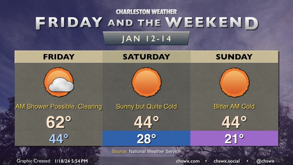
Friday will be the last time for a few days that we’ll start the day above freezing. The day starts in the mid-40s, and there’s a risk for a stray shower or two in the morning. Most will stay rain-free, though. Temperatures will head into the low 60s by early afternoon as a cold front swings through, ushering in drier air that will help scour out the cloud deck. It’ll be windy — gusts 25-30 MPH certainly appear possible as well, so keep that in mind as you commute over bridges.
We’ll start to cool off by late afternoon, and will be quickly into the 40s by 7PM. From there, we will chill out rapidly, and temperatures will fall into the upper 20s by morning. Wind chills will drop to around 20° — and perhaps lower — and could be nasty for morning runs or the like. Temperatures only head to the mid-40s in the afternoon despite full sunshine.
Saturday night into Sunday will feature the coldest temperatures. Lows will fall to the upper teens to low 20s, and wind chills could drop to around 10° or even lower in the morning. A Wind Chill Advisory is probable Sunday morning. Cold weather precautions will be a must: protect plants, pets, pipes, and people. Temperatures on Sunday will head back to the mid-40s in the afternoon, which might feel downright balmy after how the morning will start!
After one more freezing start Monday, though, we warm up — and the 70s look to be back on Wednesday.