Rest of the work week: Unseasonable warmth continues with some showers mixed in
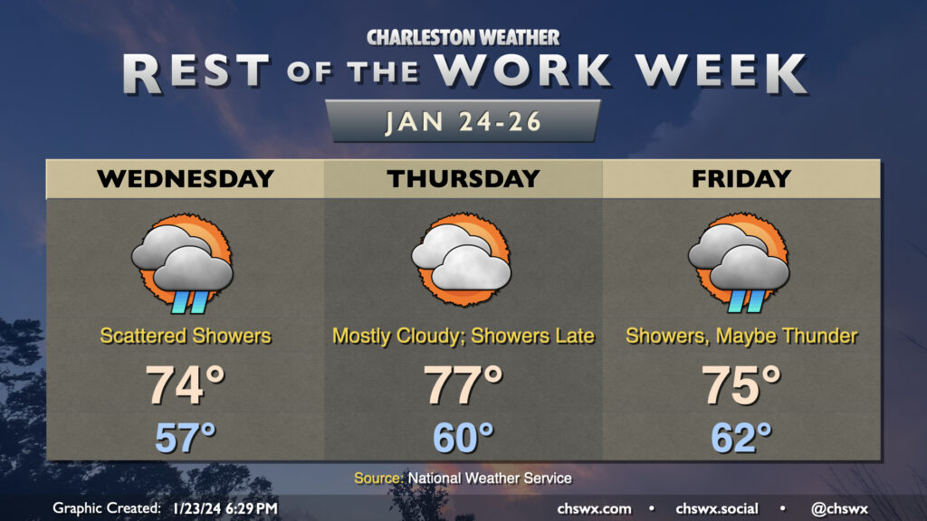
The warming trend continues Wednesday as a warm front lifts north of the area. Temperatures start in the mid-to-upper 50s owing to cloud cover blanketing us for much of the night. Once the warm front shifts ashore and winds go southeasterly, temperatures will respond further and head to the mid-70s. It’ll be kind of muggy, too, with dewpoints in the mid-60s expected behind the warm front. Scattered showers will remain possible throughout a fair bit of the day, though we should see more sun than we did Tuesday (not hard to do, tbh).
At a minimum, we’ll get the first part of Thursday in rain-free, if not the vast majority of it, before a front approaches the area and reintroduces shower and storm chances for Friday. Temperatures will peak Thursday, with lows in the low 60s and highs topping out around the mid-to-upper 70s. There will be a chance for a few showers late, but most of us should stay out of that until Friday, when shower coverage looks to increase with some thunder possible as well. Severe weather currently doesn’t appear to be a concern, though, as wind fields are largely unimpressive and instability appears meager. Temperatures on Friday will be tamped down a little by the shower activity, “only” reaching 75° after starting in the low 60s once again. We stay in the 70s on Saturday, but a second, stronger front will restore order to temperature chaos on Sunday, and by Monday, expect temperatures near normal with much more sunshine.