The week ahead: Stormy start, then turning cool and quiet
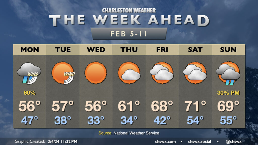
The first full week of February gets off to a stormy start as strong low pressure affects the area, particularly in the morning. We’re looking for the potential for some coastal flooding early in the day, and this combined with heavy rainfall could cause flooding problems across downtown Charleston, especially around high tide a little after 3:30am. A Coastal Flood Advisory is in effect from 2-6am for the salt water flooding threat; if that heavy rain does coincide, additional flood advisories for land-based areas would be needed. Rain does slowly taper off as Monday goes along, but we stay on the chilly side as breezy northeasterly winds blow in. This keeps highs capped to the mid-50s after an upper 40s start.
We stay chilly and windy heading into Tuesday. Clouds will depart, but winds will remain somewhat stiff out of the northeast, contributing to another possible round of coastal flooding in the morning. Wind chills will become a factor as well, and that low of 38° is going to feel closer to the upper 20s, so dress accordingly as the heat will be efficiently whipped away from your body. Temperatures in the afternoon only top out to the mid-50s once again despite full sunshine.
Wednesday will be the bottom as far as cool temperatures go. We start the day flirting with freezing, and likely hitting that mark further inland as well as in sheltered and more rural locations. Highs once again only get to the mid-50s in the afternoon under sunny skies. The one good thing about Wednesday, though, is that the winds will be backing off as high pressure moves on by.
A warming trend begins Thursday and into the weekend. Clouds will also be on the increase as high pressure slips away, but that won’t stop temperatures from heading to the low 60s Thursday, the upper 60s Friday, and the low 70s on Saturday. Lows follow suit as well: we start Thursday in the mid-30s, but will start Friday in the mid-50s! Quiet weather is expected to close the work week and start the weekend. The next shower chance arrives with a front on Sunday. Expect lows in the mid-50s and highs around 70°.
Follow my Charleston Weather updates on Mastodon, Bluesky, Instagram, Facebook, or directly in a feed reader. Do you like what you see here? Please consider supporting my independent, hype-averse weather journalism and become a supporter on Patreon for a broader look at all things #chswx!