The week ahead: Stormy start, but a lovely mid-week
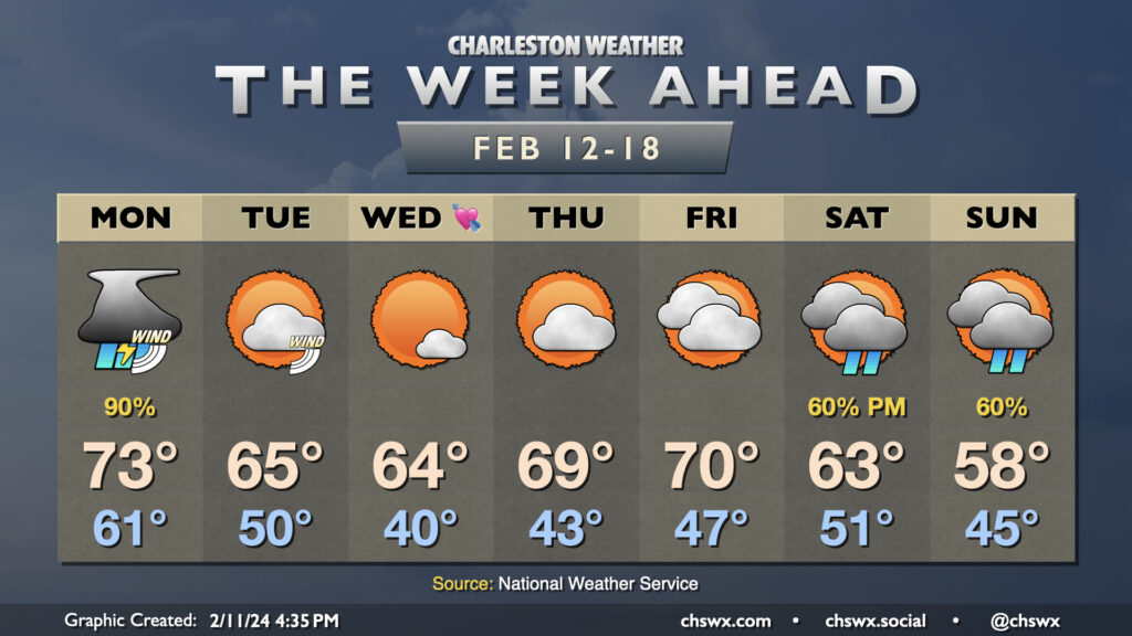
The upcoming week will get off to a fairly stormy start on Monday, but we’ll see things calm down and cool off a little bit for a few days before another storm system affects the area over the weekend.
Monday: Expect rain, maybe a few strong storms
But first, Monday. A storm system moving through the Mid-South will continue to press eastward toward our neck of the woods Sunday evening, with rain beginning in earnest overnight Sunday into Monday. This rain could be heavy at times, though the heaviest rain will be found the further north you go. Simulated radar shows the potential for a couple waves of showers and some thunderstorms, with the strongest storms possible Monday afternoon into early evening. Wind fields will be such that any thunderstorms that can get going could mix down some strong, and perhaps damaging, wind gusts. There’s also a more marginal hail threat, and if enough instability can develop, a tornado can’t be totally ruled out as there will be plenty of shear to work with.
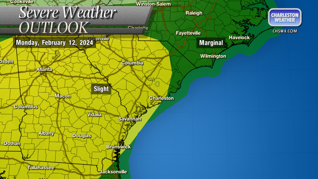
For its part, the Storm Prediction Center has the area in a Slight Risk of severe weather, with a slightly lower risk to our north and east. I wouldn’t get too hung up on the boundaries of the “Slight” and “Marginal” areas; as always, storms couldn’t care less about geographical boundaries, so let’s just all be ready for a possible strong to severe storm on Monday.
Otherwise, it’ll be one more warm and muggy day — we start Monday in the low 60s (just a hair off the normal high for February 12), warming to the low 70s in the afternoon.
Quiet weather for the rest of the work week; next storm system next weekend
Once the storm system exits Monday night, Tuesday will feature a cooldown — but nothing too heinous. We’ll start Tuesday in windy fashion, with gusts 30-35 MPH possible in the wake of the storm system’s cold front early Tuesday morning. Those winds will be gusty for a good bit of the day, but will begin to relax as we get into the evening. Tuesday starts around 50° and warms to around 65° in the afternoon — much closer to normal than we’ve been the past few days. Cloud cover will erode throughout the day, and we should be cloud-free by sunset.
Wednesday will be the coolest day of the week, though again, it won’t be too bad: expect a low temperature around 40° Wednesday morning to yield to highs in the mid-60s in the afternoon under mostly sunny skies — rather lovely weather if I do say so myself. A warming trend commences thereafter; lows in the low 40s on Thursday yield to highs approaching 70° under partly cloudy skies, while Friday will start in the upper 40s and warm to around 70° as cloud cover ticks up ahead of the next storm system to affect the area over the weekend. That storm system is expected to cool us down back below normal for next week.
Follow my Charleston Weather updates on Mastodon, Bluesky, Instagram, Facebook, or directly in a feed reader. Do you like what you see here? Please consider supporting my independent, hype-averse weather journalism and become a supporter on Patreon for a broader look at all things #chswx!