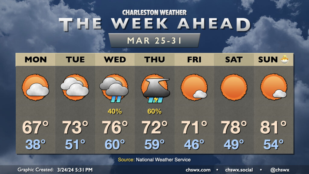
The week ahead: Generally quiet start and finish, with storms in the middle

The final week of March gets off to a chilly start, followed by another round of showers and thunderstorms, before an Easter weekend warmup that should find us getting back into the 80s before it’s over.
First, though, I wanted to thank everyone for the outpouring of love and support we’ve received over the past several days after my wife’s untimely passing Tuesday morning. A very difficult time has been made a lot easier thanks to your well-wishes. There’s a lot of healing to go, but y’all have helped tremendously. Thank you.
And now, the weather.
Monday begins the work week on a chilly note. We’ll start the day in the upper 30s in the metro, with mid-30s — and perhaps a little frost — further inland (thinking generally inland of 17-A). You might want to cover up sensitive plants as a result. Highs on Monday stay below normal under a mix of clouds and sun; expect just mid-to-upper 60s in the afternoon as a bit of a high pressure wedge pattern sets in for the day. (The normal high for March 25 is 72°.)
Cloud cover will thicken some on Tuesday as a cold front approaches from the west, but we look to stay rain-free. Temperatures will jump, especially in the morning, going from a low of 38° on Monday to lows in the low 50s Tuesday. Temperatures in the afternoon warm to the low-to-mid-70s as winds turn east and southeasterly.
The wet period of this week comes Wednesday and Thursday as a low pressure system and its associated fronts affect the area. Expect generally scattered showers on Wednesday to lead to more likely shower and thunderstorm chances later Wednesday into Thursday as the low traverses the Carolinas. Temperatures reach a peak on Wednesday before cooling some for Thursday as the front moves by.
Rain clears the area by Friday, yielding a mostly sunny day with temperatures around if not slightly below normal. We then warm up big-time heading into Easter weekend, with upper 70s on Saturday and low 80s possible Easter Sunday with quiet weather expected.
Programming note
The podcast will remain mostly on hiatus for the next few weeks while I continue to navigate my family’s loss. Posts here will be a little more sporadic as well for the near term. Expect the next forecast update on Tuesday night ahead of Wednesday and Thursday’s rain. We’ll see you then.
Follow my Charleston Weather updates on Mastodon, Bluesky, Instagram, Facebook, or directly in a feed reader. Do you like what you see here? Please consider supporting my independent, hype-averse weather journalism and become a supporter on Patreon for a broader look at all things #chswx!