The week ahead: Turning hot, but a pleasant weekend awaits
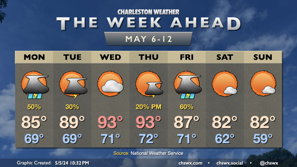
The upcoming week will be on the warm side as ridging aloft builds in, sending mid-week temperatures well into the 90s and perhaps into record territory.
First, though, we deal with another round of scattered showers and thunderstorms for Monday. Temperatures on Monday start once again in the upper 60s to near 70°, warming to the mid-80s as one last upper disturbance makes its way through. We should see thunderstorms fire up around or a little after midday and generally remain scattered in nature. A few heavy downpours will be possible, and a strong storm can never be totally discounted near where boundaries collide — and on the flip side, some of y’all might not see any rain at all. (That time of year!)
The heat commences on Tuesday. Temperatures head to near 90° in the afternoon with a few thunderstorms possible, though most of us stay rain-free. Wednesday and Thursday could challenge record highs as temperatures rise into the low-to-mid-90s each afternoon. The cap should hold Wednesday, precluding shower and thunderstorm formation, and there’s only a slight chance at a little thunderstorm relief later Thursday.
A cold front arrives Friday with scattered to numerous thunderstorms expected across the area, particularly as we get later into the afternoon and evening. A strong to severe storm might not be totally out of the question with this front, but it will probably serve as the best rain chance since Monday across the area.
The payoff, though, will be a much more seasonable late-spring weekend of weather. Expect lows on Saturday to start in the low 60s, almost 10° cooler than we’ll start Friday. We might even dip back into the 50s on Sunday morning. Highs each afternoon will run in the low 80s, right near if not a touch below mid-May norms, and there will be plenty of sunshine to be had — a fantastic Mother’s Day gift from Mother Nature if I do say so myself!
Follow my Charleston Weather updates on Mastodon, Bluesky, Instagram, Facebook, or directly in a feed reader. Do you like what you see here? Please consider supporting my independent, hype-averse weather journalism and become a supporter on Patreon for a broader look at all things #chswx!