The week ahead: Pattern turns active, with periods of unsettled weather
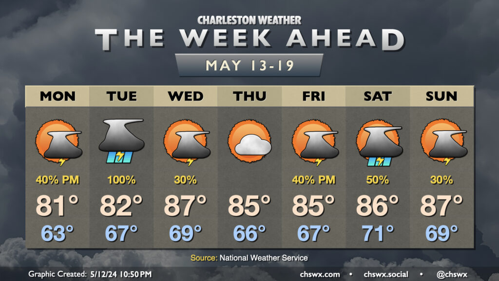
I hope everyone got to enjoy this fine Mother’s Day weekend, because we are getting back to storms for a good chunk of the upcoming week. We start Monday on a dry note, but shower and storm chances will increase as a disturbance moves across the Gulf Coast states toward the East Coast. We start Monday in the low 60s, warming to the low 80s in the afternoon with clouds on the increase ahead of shower and thunderstorm chances later in the day.
Heavy rain, strong storms possible Tuesday
Tuesday looks decidedly not fun. Heavy rain on the order of 2-3″ will be possible as numerous thunderstorms develop and move across the area. This could have at least morning commute impacts, and trends in guidance suggest one round clears the area before another round fires off for the evening commute. A severe storm or two can’t be ruled out either, but the greater risk appears to be from heavy rainfall and the potential for some minor flooding. Temperatures start warmer Tuesday, generally in the mid-60s — but only head to the low 80s in the afternoon given the clouds and rain that are expected.
Mid-week lull leads to more unsettled weather this weekend
Once Tuesday’s disturbance gets offshore, rain chances diminish — but don’t vanish entirely — on Wednesday. Scattered showers and a few thunderstorms will be possible with some leftover vorticity aloft and plentiful moisture in place. Outside of storms, it’ll turn fairly warm: expect highs in the mid-to-upper 80s Wednesday afternoon. A mid-level ridge nudges into the area briefly Thursday, squelching thunderstorm chances and allowing highs to top out generally in the mid-80s under partly cloudy to mostly sunny skies. The respite is short, though, as the active pattern brings another disturbance (or series of disturbances) into the area for Friday and the weekend, generating at least scattered shower and thunderstorm chances. Highs generally run in the mid-to-upper 80s, with lows in the upper 60s to around 70° being fairly common.
Follow my Charleston Weather updates on Mastodon, Bluesky, Instagram, Facebook, or directly in a feed reader. Do you like what you see here? Please consider supporting my independent, hype-averse weather journalism and become a supporter on Patreon for a broader look at all things #chswx!