The 2024 hurricane season begins
Welcome to the 2024 hurricane season, everybody. From now through November 30, we’ll keep one eye out on the Atlantic basin for whatever spinny mischief may try to get going. The outlook for this year is for an incredibly busy season thanks to flat-out hot water well into the Atlantic and the expectation that we’ll be in La Niña, which tends to relax shear over the Atlantic and turbocharges the environment for tropical cyclone formation as a result. Of course, the outlook only shows how many storms will probably form; it’s not an indicator of how many of those will make landfall, much less where they may do so. It only takes one storm to make a season memorable for all the wrong reasons, too.
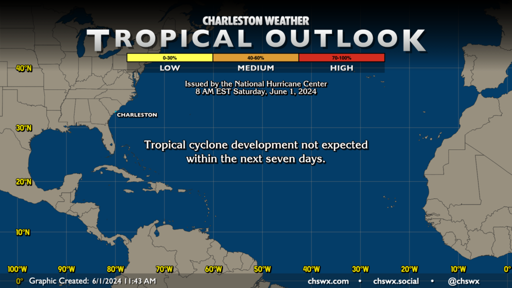
The good news to start the season is that tropical cyclone development isn’t expected for the next seven days. We didn’t even have any preseason activity this year for the first time since 2022. However, as we all know, tropical cyclones can spin up on a dime, so it’s important for us all to be prepared. To paraphrase John Philpot Curran, Thomas Jefferson, and others: the price of living in Charleston is six months of tropical vigilance.
This year’s names
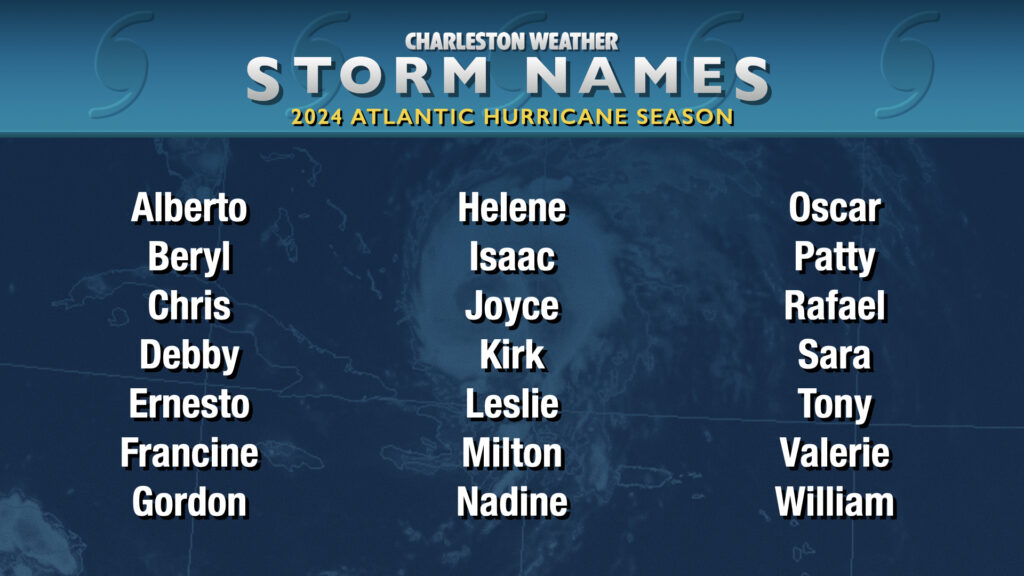
We’re swinging back around to the list of names last used in 2018, headlined by long-time mainstays Alberto, Beryl, and Ernesto (among others). New names this go-around include Francine, which replaces Florence, and Milton, which replaces Michael. The name retirements are out of respect to Florence’s incredible flooding rains in the Carolinas and Michael’s tightly-wound fury being unleashed on the Florida Panhandle during the 2018 season. The name lists rotate every six years; see the National Hurricane Center website for more on how the lists are made.
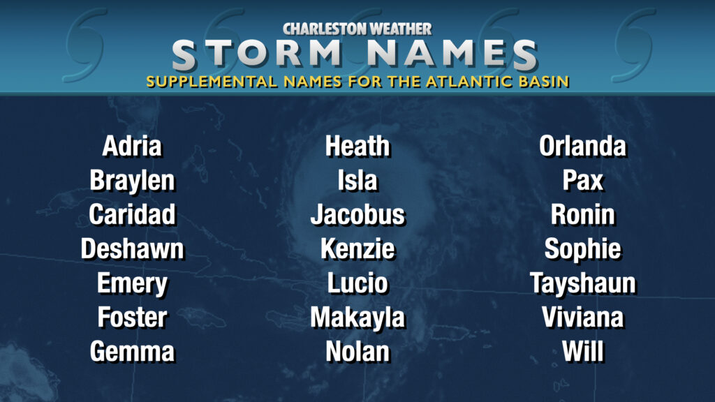
Since the incredibly active 2020 season shined a light on the flaws of using the Greek alphabet as the overflow list for storm names, the World Meteorological Organization commissioned a supplemental name list for the Atlantic basin. These names do not rotate, but make retirements significantly easier in the event one of these storms rises to that level. The NOAA outlook strongly suggests we may dip into this list for the first time this season, so it’ll be worth getting familiar with at least the first few on the list.
Prepare today, avoid stress tomorrow
The best time to get ready for hurricane season is a day like today: partly cloudy skies, temperatures in the low 80s, with no tropical cyclone threats in sight. The South Carolina Emergency Management Division has an excellent hurricane guide with everything you’d need to know, including what to put in your preparedness kit as well as your evacuation zones in case, God forbid, we need to get everyone out of the way of a storm. Evacuation zones were updated for the 2024 season, so it’s important to make sure you Know Your Zone as it may have changed.
Why you should use the NHC forecasts for your decision-making
Let’s get this out of the way: The official National Hurricane Center forecast, paired with local statements from the National Weather Service in Charleston, should be the basis for your decision-making. It’s somewhat incredible just how much weather model data is now available on the Internet, but you should never rely on a spaghetti plot of possible tracks to judge your risk because those models may not be reliable for all scenarios. The models are just a piece in a complex forecast puzzle that the experts use to create the forecast. The National Hurricane Center forecasters are some of the best in the world at this; lean on and trust that expertise!
When looking at the forecast, there’s also the matter of the Cone of Uncertainty and what that ultimately means. The cone is simply a graphical representation of where the center could track. Hurricanes, though, are not a point on a map, they are sprawling complexes of bad weather whose effects can stretch hundreds of miles from that point. In other words, just because the cone may not come over a particular area, that doesn’t mean that area is necessarily in the clear. One adjustment the National Hurricane Center is launching later this summer is to show inland watches/warnings on the cone graphic (PDF). This should hopefully do a better job of showing where the risk for tropical cyclone hazards truly lies beyond simply the cone or the coastal watches/warnings that have previously been displayed there. It’s a great idea, and I’ll be tweaking my own graphics to show this display going forward as well.
Hurricane season can be anxiety-inducing, but we will be fine
Storm anxiety tends to peak during hurricane season, especially for those who may have been through the brunt of one. Hugo, despite happening almost 35 years ago, still rings very fresh in the minds of many Charlestonians. The best way to confront storm anxiety is to get prepared — have what you need ready to go so that you don’t have to get into the anxious throngs of people who aren’t prepared if a storm ends up threatening us.
It’s also important for most of us to not obsess over the tropics in our day-to-day lives (unless that’s something you’re highly interested in). Check back with the outlooks periodically; I and every other weather-adjacent media outlet in the area will keep you posted on what’s happening out there in a matter-of-fact way that leans on science and facts. We’re all quite judicious about raising the alarm, too. There are a lot of alternative sources out there these days that pop up on Facebook along with other social media sites and quite literally profit off scaring the bejeezus out of people with Scary-Looking Model Runs that end up not panning out. Please, don’t fall for it — listen to trusted sources of information throughout the season. They will not lead you astray.
Finally, we’re all in this together, and in the end, we’ll be fine, especially if we all get ready during the quiet times in case things become decidedly less-than-quiet.
Follow my Charleston Weather updates on Mastodon, Bluesky, Instagram, Facebook, or directly in a feed reader. Do you like what you see here? Please consider supporting my independent, hype-averse weather journalism and become a supporter on Patreon for a broader look at all things #chswx!