The week ahead: Not quite as hot, storms from time to time
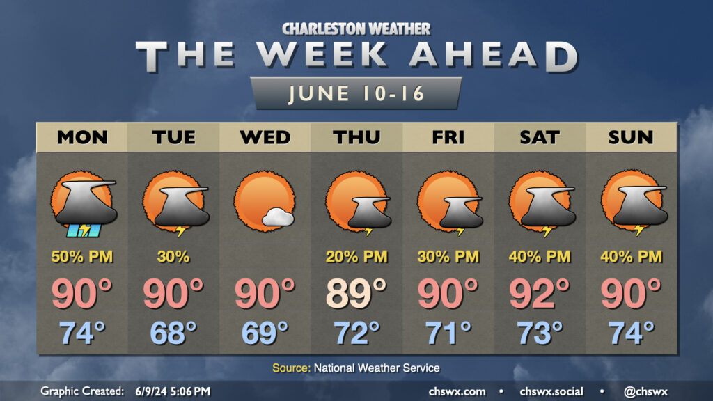
After highs topped out in the mid-90s on Sunday, we’ll see temperatures back down a little bit toward normal heading into the upcoming work week as a front crosses through and stalls out nearby, potentially bringing a somewhat unsettled Monday. Showers and thunderstorms could be in the area during the morning hours, but the better chance for rain arrives in the afternoon and evening as more forcing arrives. Temperatures start in the mid-70s, heading to around 90° under a mix of sun and clouds.
Showers and storms become more sparse Tuesday as drier air filters into the area, while storms should be temporarily squelched on Wednesday. We remain in the 90s each afternoon, though lows will run a few degrees cooler — generally bottoming out in the upper 60s away from the coast.
More standard summertime afternoon shower and thunderstorm chances return to the forecast by Thursday and continue into the weekend as moisture surges back northward from the Gulf in association with low pressure. It won’t rain all day at any one location, so just make sure your weekend plans have an indoor backup. Temperatures look to generally hang around normal — generally around 90° each afternoon after starting in the low to mid-70s.
Follow my Charleston Weather updates on Mastodon, Bluesky, Instagram, Facebook, or directly in a feed reader. Do you like what you see here? Please consider supporting my independent, hype-averse weather journalism and become a supporter on Patreon for a broader look at all things #chswx!