Friday & the weekend: Unsettled start as heat builds back up
We’ve got a couple fairly active weather days ahead as low pressure nudges a front back inland across the area starting Friday. Then, heat really starts to build in on Sunday, with a stretch of heat indices well into Advisory territory expected to last several days.
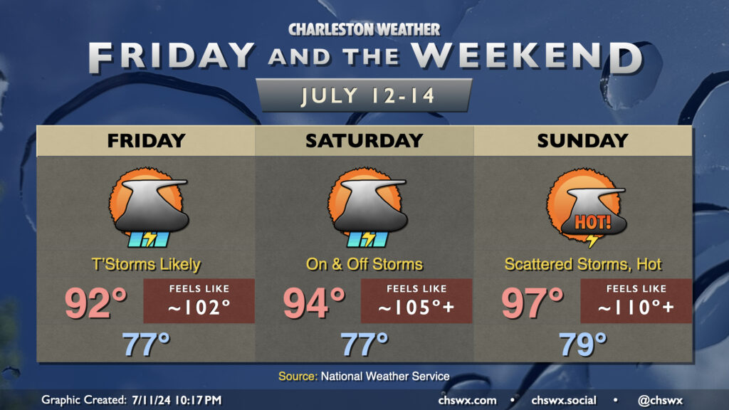
Guidance suggests we could get off to an early start to spotty showers and thunderstorms on Friday before coverage becomes more widespread as the seabreeze kicks in later in the day. Temperatures start in the upper 70s to low 80s, warmest near the coast, warming to the low 90s in the afternoon in-between storms. Factor in dewpoints in the mid-70s and it’ll feel closer to the low 100s. Many of us should see some decent rain; an inch of rain looks to be a good bet in many spots, with some spots receiving upwards of 2″ (and maybe even a little more where locally heavy rainfall occurs). Severe weather is not expected, but minor flooding could occur where storms train. As the sun heads down, expect coverage to decrease.
Storms will continue into Saturday as energy aloft and low pressure at the surface affect the area for one more day. They’ll be a little more scattered in nature, though many of us could see some measurable rainfall once again. After another upper 70s to low 80s start, temperatures head back into the mid-90s in the afternoon with some spots flirting with Heat Advisory conditions (heat indices 108°+) in between storms.
Sunday will turn even hotter, with temperatures heading into the upper 90s in the afternoon. Heat indices should venture into Heat Advisory territory, with fewer storms to cool some of us off as the pattern shifts back to a more traditional summertime setup with the Bermuda high to our east and the seabreeze pushing inland to kick off showers and storms. You’ll want to make sure you’re taking heat precautions if you find yourself out and about during the height of the afternoon. The hot temperatures look to stick around into at least the first part of next week, too, with heat indices perhaps approaching 110° at times with scattered afternoon storms to cool a few of us off.