The week ahead: Heat, humidity, and afternoon storms continue
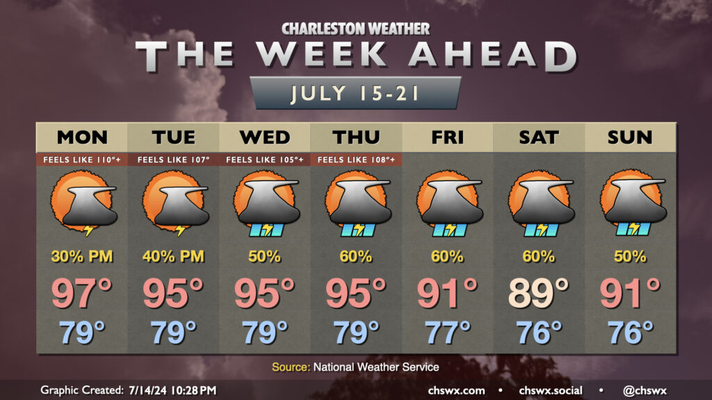
After reaching 99° at the airport on Sunday — the warmest it’s been since May 29, 2019, when it was 101° in the midst of the Memorial Day heat wave — air temperatures make another run for the upper 90s on Monday after another steamy start in the upper 70s to low 80s as a deep-layer ridge stays in place. Given the moisture in place, heat indices should once again reach or exceed Heat Advisory criteria (108°) in many spots, especially in the Highway 17 corridor. A few showers and thunderstorms will be possible once again Monday afternoon and evening along and ahead of the seabreeze, but with the ridge in place, coverage will be scattered at best. Much like Sunday, we can’t rule out a stronger storm where one does fire if it can realize the considerable instability that will be available to it. Additionally, storm motions should again be fairly slow, and with a juicy atmosphere, some localized flooding will be possible if a storm does fire and hang out for a bit.
Air temperatures will remain in the mid-90s for the heart of the work week, though as the ridge aloft weakens and retreats, we’ll see an uptick in shower and thunderstorm chances as the week goes on. Scattered coverage appears probable again Tuesday, with more widespread showers and thunderstorms possible starting Wednesday. It’ll still be plenty hot, especially with lows continuing to flirt with 80° away from the coast, but with the increase in storms and cloud cover, we should have a harder time reaching advisory-level heat indices.
Models suggest even higher coverage of showers and storms heading into the weekend as a little more energy digs the trough a little deeper on Friday before it begins to weaken some on Saturday into Sunday, allowing the subtropical ridge to build back in a little more. The uptick in activity, though, should bring air temperatures back down to earth a little, maybe even dipping a touch below normal (though when normal is around 92°, that’s still plenty warm). As always, while widespread severe weather in the absence of a well-organized weather system is highly unlikely, a few storms could pulse up above severe limits.
Programming note
Professional responsibilities are once again whisking me away for a few days, so human posting will be spotty and otherwise left to the bots through Friday. As always, make sure you have multiple ways to receive weather warnings, including one that doesn’t require the Internet.
Follow my Charleston Weather updates on Mastodon, Bluesky, Instagram, Facebook, or directly in a feed reader. Do you like what you see here? Please consider supporting my independent, hype-averse weather journalism and become a supporter on Patreon for a broader look at all things #chswx!