Sunday: Scattered to numerous storms possible ahead of Debby
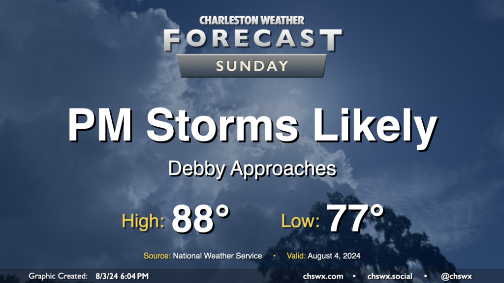
Tropical Storm Debby, newly christened as of 5PM, will march up the Florida coast on Sunday, strengthening as it goes over 90°+ degree water in the Gulf of Mexico. Here at home, moisture will begin to increase ahead of the storm, and that should lead to scattered to numerous showers and thunderstorms in the afternoon and evening hours. Expect balmy lows in the upper 70s to yield to highs in the upper 80s in the afternoon as the flow begins to turn more onshore and showers and thunderstorms become more numerous. A strong storm or two can’t be ruled out, as is normally the case this time of year.
Debby to strengthen to a hurricane before Florida landfall; from there, more track uncertainty
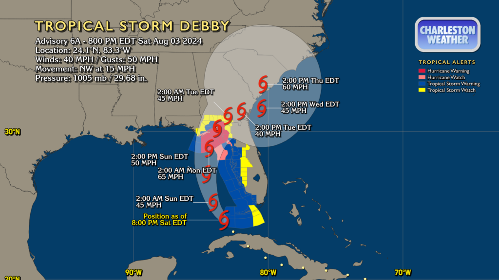
The 5PM track and intensity forecast update upgraded Tropical Depression Four to Tropical Storm Debby as its maximum winds are now at 40 MPH. As of this writing, Hurricane Hunters are flying around in the system figuring out what’s what, which will be crucial information to feed into the models.
The track forecast is fairly solid up to landfall in Florida on Monday afternoon. From there, it becomes rather uncertain as Debby’s steering largely collapses with a high to the north blocking its escape, perhaps keeping it around the Southeast US through the end of the week. As far as impacts here, we can expect rain bands to begin as early as Monday, with persistent on and off downpours expected through at least mid-week. The rest of the traditional hurricane impacts — storm surge, strong winds, isolated tornadoes — are much tougher to pin down right now because of the track forecast uncertainty. There will be more details to be had on these threats as we head into the next couple days, so please continue to watch forecast updates.
NWS: “Rainfall totals and flooding impacts could potentially fall into a very rare and uncommon category”
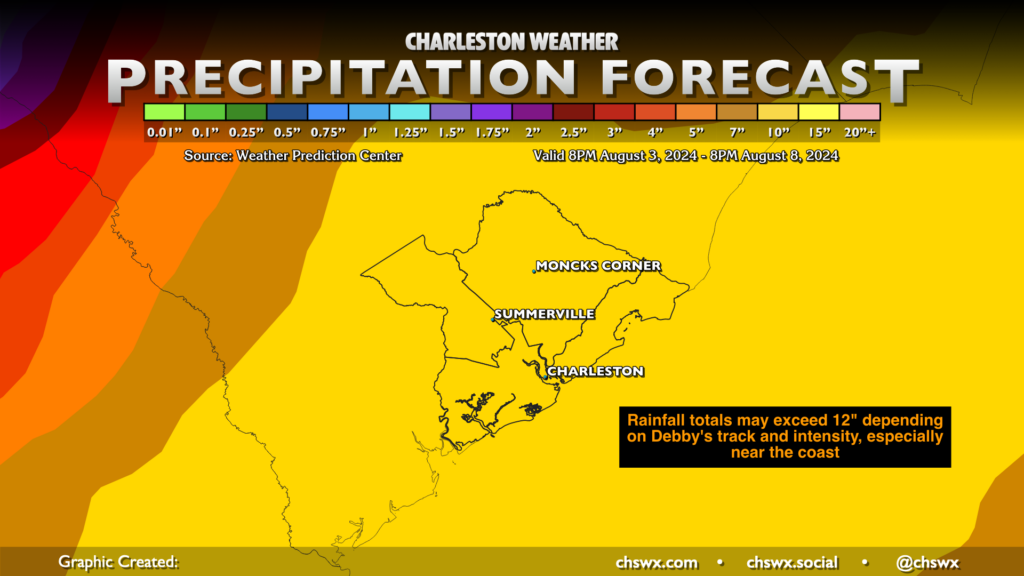
A stalling tropical cyclone usually means quite a bit of rain over a particular area for an elongated period of time, and the current forecast strongly suggests that the SC coast, including the Charleston metro, will be in the bullseye. Rain totals approaching a foot for some spots, and maybe even higher totals, cannot be counted out at all depending on where the storm ultimately drifts. If this is evoking some October 2015 memories, it’s completely understandable as these forecast rain totals are, as the National Weather Service called it in their evening briefing, “very rare and uncommon.” Flash flooding is undoubtedly going to be the main concern, especially in low-lying areas, downtown Charleston, and along rivers. While exact amounts and timings are still quite uncertain given the questions around the long-term track, confidence is increasing that water impacts will be the main story of Debby.
What to do Sunday
Take Sunday to get some preparation done. If you need sandbags, I’d go get ’em then. Check your hurricane kit and make sure you have what you need in case your power is out for an extended period or travel becomes treacherous. If October 2015 is any guide, it’s very possible businesses could close preemptively to keep their employees safe, so keep that in mind if there are things you need. And yes, while still unclear, a high wind threat is certainly not out of the question, especially if the storm meanders back into the Atlantic and strengthens (as the current forecast indicates), so being ready for power outages is incredibly prudent. Power outages or not, the upcoming week is just not looking awesome, so get what you need to be comfortable and safe.
Continue to monitor forecast updates from the National Weather Service in Charleston and the National Hurricane Center as we get closer to this (that’s what I’ll be relaying here). They’re the experts on this stuff, and it’s time to rely on that expertise. (I know I do.)
Follow my Charleston Weather updates on Mastodon, Bluesky, Instagram, Facebook, or directly in a feed reader. Do you like what you see here? Please consider supporting my independent, hype-averse weather journalism and become a supporter on Patreon for a broader look at all things #chswx!