The week ahead: Dealing with Debby
The weather story this week is Tropical Storm Debby. Some rain associated with the system has already tried to push ashore Sunday evening, and there’s a lot more where that comes from as we get into the first few days of the new work week. The forecast continues to call for Debby to stall out and meander over Georgia, causing excessive rainfall that could lead to widespread significant flooding across the Lowcountry over the next several days. We will also deal with the potential for tropical storm-force winds, storm surge, and tornadoes as well. The slow-moving nature of the storm increases the uncertainty about exact numbers for impacts as well as on timing, but we’ll do our best here within the limits of the science.
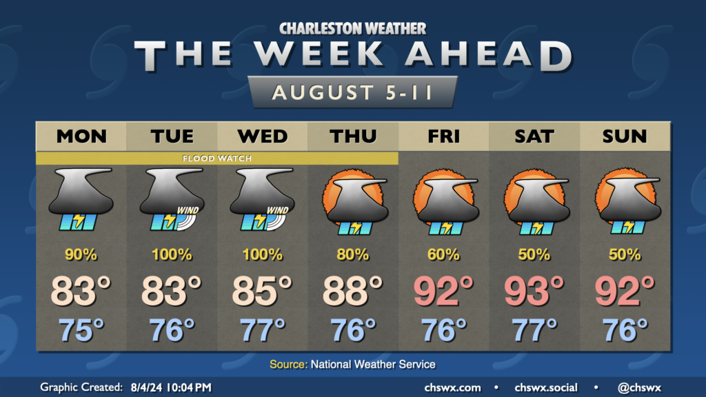
Monday
We should begin to see Debby’s rain bands in earnest begin on Monday. Torrential downpours will be a common story throughout the day. There will be breaks in the rain as we often see within rain bands, but the efficiency of the rainfall should easily lend itself to 1-3″ of rain for many of us just on Monday alone. Winds could turn gusty within bands as well — I wouldn’t rule out a few 40 MPH gusts at times, especially later in the day.
We will also need to watch closely for the potential for isolated tornadoes within rain bands. Tropical tornadoes can form and dissipate very quickly, as we saw in Goose Creek during Idalia. They are excruciatingly tough for warning forecasters to handle. If a tornado warning is issued, you’ll want to take immediate action to get into an interior room away from windows. The good news is that you won’t need to be in that safe place for too long.
Temperatures will be suppressed to the low 80s thanks to the clouds and rain.
I’d consider Monday your last best day to gather supplies and get vehicles and people into where they’ll be for the duration of the storm. From there, you’ll just want to hunker down.
Tuesday-Thursday (and beyond?)
The peak of Debby’s impacts should be felt Tuesday through Thursday as steering completely collapses and the storm drifts over GA. It looks like we will remain in the northeast quadrant of the storm, so the tornado threat continues. We’ll see an increase in storm surge risk as well — it’s not yet clear when it will peak, but 2-4′ of salt water inundation may be possible. The current total water forecast calls for a 7′ tide Tuesday evening around 10 PM, but this may be exacerbated by very, very heavy rainfall. High-resolution guidance has been pinging on an intense band of rain that could move across the Tri-County during the day Tuesday, which would bring significant rainfall on the order of a few to several inches to many of us. This, combined with the potential for elevated tides, will hinder drainage and should promote widespread urban flooding particularly downtown. Flooding won’t be limited to there, though — creeks and streams should rise, and we may see flooding develop in other trouble spots such as parts of Summerville as well as Shadowmoss and by Long Point Road at Snee Farm in Mount Pleasant.
For folks near the coast, winds will begin to become a greater player in the weather as the center should drift closer. Tropical storm-force gusts certainly look possible at the coast, and we may see those gusts get pulled down further inland within rain bands, too.
There will be lulls in the rain, but the onslaught of continued rain bands with a solid feed of tropical moisture from the Atlantic as the center continues to drift across GA should drive rain totals above a foot in some spots perhaps as early as Wednesday. Expect heavy rain to continue through at least Thursday, with scattered to numerous storms possible Friday into the weekend as well. By the time it’s all over, rainfall totals in some spots could reach historic proportions, and the flooding could be very bad for some of us.
Finally, it must be reiterated that the storm’s erratic motion and weak steering add a lot of uncertainty to the forecast, especially Thursday and beyond, when the GFS has the center retrograding westward across Georgia while the ECMWF has the center moving into the Pee Dee. It’s not out of the question for us to be dealing with some prolonged effects even longer than currently forecast. There is also the question of the storm drifting out over the water and gaining some steam. Right now, a brief incursion back over water is in the forecast, but no significant strengthening is indicated. However, a longer duration over the water could change that. Again, all things we’ve got to watch closely.
Stay weather aware this week!
It’s critical over the next several days to keep an ear and an eye out for weather warnings. Make sure you have multiple ways to receive weather information, including one that doesn’t require an Internet connection. Keep your phones and battery bricks charged, too, as power outages are not out of the question. If you will use a generator, please run it outdoors to ensure no carbon monoxide buildup indoors.
You can follow along with weather updates right here on chswx.com; the homepage has been retooled to show more breaking weather updates. While these get cross-posted to social media, it’s helpful to have one place to see everything that’s happening.
Stay safe, friends — we will be okay, it’s just going to be a fairly rough several days.
Follow my Charleston Weather updates on Mastodon, Bluesky, Instagram, Facebook, or directly in a feed reader. Do you like what you see here? Please consider supporting my independent, hype-averse weather journalism and become a supporter on Patreon for a broader look at all things #chswx!