Rest of the work week: Debby to continue to bring heavy rain, gusty winds
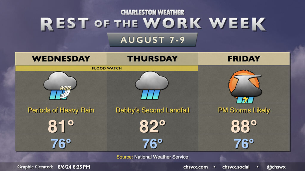
Tropical Storm Debby will continue to figure prominently in the forecast as we head through the middle of the week with continued periods of heavy rain and gusty winds before a more standard summertime pattern once again starts to take hold Friday.
8PM: Debby treks offshore
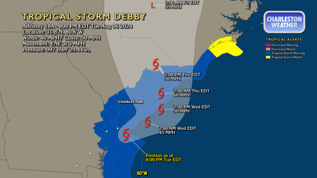
The 8PM intermediate advisory placed the center of Debby back over water, just offshore of the Georgia coast and some 85 miles south-southwest of Charleston. Its top winds were still 40 MPH, though the estimated minimum central pressure went down a couple ticks to 997 millibars. The forecast calls for some gradual strengthening as it meanders over the water Wednesday into Thursday, but the land interaction has done quite a number on Debby’s core which will impede more strengthening. It’ll drift northeastward before the Atlantic ridge pushes it back onto the South Carolina coast — probably somewhere between Mt. Pleasant and Myrtle Beach — early Thursday morning. During the day Thursday, it’ll get picked back up by a trough and will be whisked away to the northeast, continuing to spread flooding rains along its path all the way into New England.
The Charleston area remains under a Tropical Storm Warning and a Flood Watch. Flash Flood Warnings cover the entire Tri-County area as well to account for continued hydrological issues as rain continues to fall, albeit at a lighter pace.
Debby’s impact thus far
Debby has been an impactful tropical cyclone for many people, and we’ve still got a couple days left with it. Flooding rains, as expected, have made the greatest impact. Numerous road closures have taken place all over the Lowcountry, with some roads even being washed out. There was even some washing out of some land off the Paramount/Dorchester exit on 526, which also had issues during the October 2015 flood.
Elsewhere, creeks such as Church Creek in West Ashley continued to cause problems for Shadowmoss, Hickory Hill, and Crosstowne Church. In Huger in Berkeley County, French Quarter Creek entered major flood stage, which often leads to homes being flooded in that area. And, of course, downtown flooded too, but you probably didn’t need me to tell you that.
Some rain totals so far
Through 2:30 PM, many stations across the area had recorded at least 8″ of rain since the onset of Debby according to the National Weather Service. A few of those totals, just from Charleston County:
Edisto Beach 5.4 NNW         12.42 in  0700 AM 08/06   COCORAHS
Edisto Beach 5.1 NNW         11.61 in  0740 AM 08/06   COCORAHS
Charleston 2.5 NNW           11.00 in  0810 AM 08/06   COCORAHS
Edisto Beach 2.7 N           10.81 in  0700 AM 08/06   COCORAHS
Mount Pleasant 8.1 NE        9.86 in   1041 AM 08/06   COCORAHS
Johns Island 5.0 W           9.40 in   0800 AM 08/06   COCORAHS
Wadmalaw Island 4.1 NE       9.38 in   0800 AM 08/06   COCORAHS
Ace Basin                    9.27 in   0200 PM 08/06   RAWS
Charleston 1.7 SE            9.15 in   0900 AM 08/06   COCORAHS
Ravenel 2.0 WNW              8.91 in   0700 AM 08/06   COCORAHS
North Charleston 4.0 SSE     8.72 in   0700 AM 08/06   COCORAHS
Hollywood 5.8 WSW            8.70 in   0915 AM 08/06   COCORAHS
1 SE Edisto Island           8.56 in   0700 AM 08/06   COCORAHS
Hollywood 4.3 SE             8.54 in   0700 AM 08/06   COCORAHS
Meggett 1.8 W                8.43 in   0700 AM 08/06   COCORAHS
North Charleston 3.7 ESE     8.10 in   0825 AM 08/06   COCORAHS
Charleston 2.3 NE            8.09 in   0800 AM 08/06   COCORAHS
Folly Beach                  8.08 in   0845 AM 08/06   COCORAHS
Mount Pleasant 1.9 ESE       8.06 in   0945 AM 08/06   COCORAHS
Charleston 4.0 NW            8.01 in   0700 AM 08/06   COCORAHS
Charleston 2.8 NE            8.00 in   0700 AM 08/06   COCORAHS
Tornado impacts
As many of us who were up at an ungodly hour on Monday night know, tornadoes were also a significant issue as Debby’s primary feeder bands moved through. So far, the National Weather Service has confirmed tornadoes at Edisto Beach and in Moncks Corner. The Edisto Beach tornado was surveyed as an EF1 with maximum winds near 100 MPH. It was on the ground for almost three miles. Fortunately, nobody was hurt or killed.
The damage from the Moncks Corner tornado is still being evaluated for a rating, according to the National Weather Service.
National Weather Service damage survey teams will also be investigating possible tornadoes in West Ashley, Isle of Palms, Kiawah (where damage was reported as well), and Lady’s Island in Beaufort County.
What’s next?
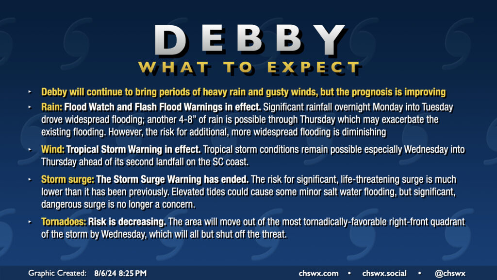
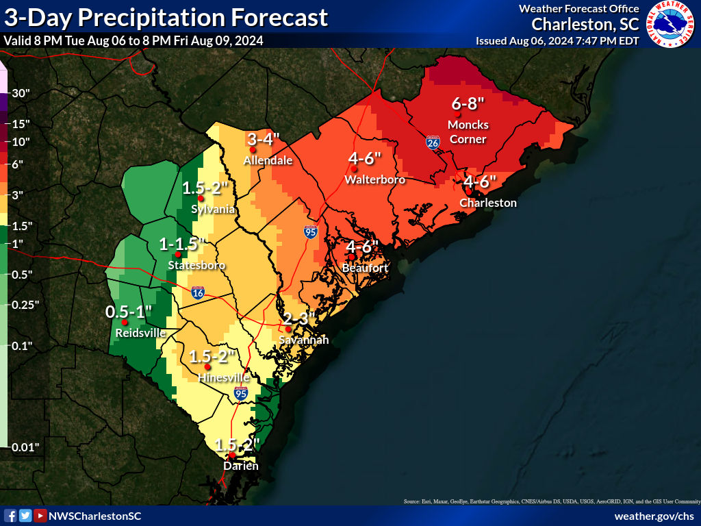
Debby will continue to meander off the coast for the next couple days before getting a move-on Friday. We will still be contending with a fair bit of rain both Wednesday and Thursday, though the intensity of the rain will likely not match up to Monday. Overall, expect another 4-6″ of rain in the Charleston metro proper, while upwards of 8″ will be possible closer to the Santee. This will put storm totals of a foot well in reach for many stations, which is generally in line with what was forecasted. The risk for additional flash flooding, while a little lower, is still not zero, especially if a couple downpours train on each other back to back.
Wind and saltwater impacts
Gusty winds will remain a concern within squalls and as Debby makes its approach to its second landfall on the SC coast Thursday, with tropical storm-force winds remaining a possibility at the coast. Thus, the Tropical Storm Warning remains in effect.
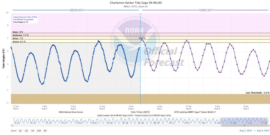
With the storm now expected to make landfall north of the Charleston area, the risk for storm surge has diminished, and so the Storm Surge Warning that had previously been in effect has been discontinued as of the 5PM advisory. While tides could rise to action stage and maybe even minor flood, significant surge impacts are no longer on the table, which will take out a vector for additional flooding problems on the barrier islands as well as downtown.
Tornado threat
The tornado threat will continue to decrease heading into Wednesday as Debby pulls slowly eastward, getting us out of that right-front quadrant that is most suitable for tornadoes. While one can’t be totally discounted while we are in the quadrant overnight Tuesday into early Wednesday, the best lineup of shear and instability associated with Debby is well to our north at this point, so the risk for tornadoes is quite low here. The previous tornado watch for the Lowcountry was canceled at 4 PM, indicating the risk has diminished. Keep a way to receive weather alerts that can wake you handy, but you should feel much more comfortable getting a good night’s sleep tonight. (I know I will.)
Return to normalcy
Debby will be accelerating northeastward by Friday. We’ll still have quite a bit of moisture in play, and that should allow for numerous afternoon and evening showers and thunderstorms to develop. This isn’t ideal after much of the rain we got during Debby, but it will at least be in more of a normal summertime pattern. This will continue heading into the weekend, with rain chances gradually diminishing to the standard isolated to scattered afternoon coverage we’ve come to know and love by Sunday.
What to do
- It’s still not a bad idea to limit your travel over the next couple days, especially in flood-prone areas or around areas that may have had roads wash out. Whether by vehicle or on foot, stay out of flooded roads! There’s still a fair bit of rain left to fall, and one poorly-placed downpour could contribute to a resurgence, albeit temporary, of flooding in some spots. Additional Flash Flood Warnings could be required.
- Be listening for river flood warnings if you are along the Edisto or the Santee. River flooding is going to be one of the longer-lasting legacies Debby will leave, and may cause properties to flood.
- Keep batteries charged. With such saturated soils, we won’t need much in the way of tropical storm-force winds to bring trees and power lines down, so the risk of sporadic outages will stick around.
- Hang in there — we’re halfway through, and the other half is probably not going to be as bad as the first. We’ll be done with this before you know it.
Follow my Charleston Weather updates on Mastodon, Bluesky, Instagram, Facebook, or directly in a feed reader. Do you like what you see here? Please consider supporting my independent, hype-averse weather journalism and become a supporter on Patreon for a broader look at all things #chswx!