Thursday: Debby begins its exit
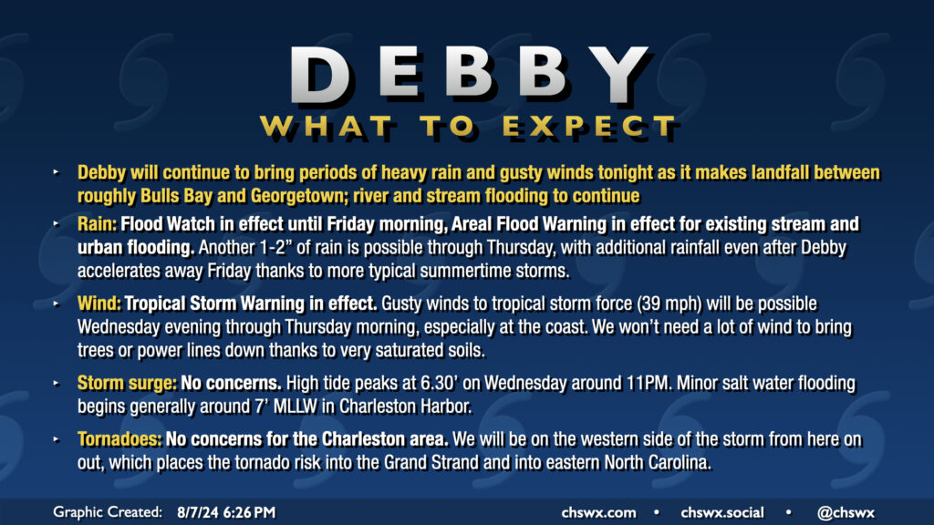
Tropical Storm Debby will make landfall on the South Carolina coast somewhere around Bulls Bay up to Georgetown (taking the cone literally, the margin for error is between Mt. Pleasant and Myrtle Beach) overnight as it turns northward in response to high pressure building back in from the east. This landfall likely won’t really come with much fanfare as Debby’s inner core was hollowed out by land interaction and dry air over the past day or so. The strongest winds, in fact, are well away from the center of the storm. Still, there’s a risk for tropical storm-force winds at the coast and within gusts in rain bands, so the Tropical Storm Warning continues. With such saturated soils, it won’t take too much in the way of wind to bring trees down, so we’ll want to stay a little vigilant about possible power outages.
Showers with occasional downpours and some gusty winds to around 35 MPH have been commonplace throughout Wednesday and that should continue into the overnight through Thursday. Another inch-plus of rain should fall overnight through Thursday morning in the metro proper, with upwards of 2″ possible further inland (generally north and west of 17-A) where a fairly persistent rain band has been parked for a fair bit of the day.
We should see generally improving conditions on Thursday. Some spots may get another half-inch of rain or so as Debby begins to depart the area, and it’ll still be a little breezy, but overall, Debby’s effects will be winding down. Expect temperatures on Thursday to run a little warmer than they have in previous days, heading into the mid-to-upper 80s in the afternoon as the cloud shield begins to thin out.
Debby’s impacts continue
As expected, flooding continues to be the major concern across the metro area, and this story will continue to unfold over the next few days. An Areal Flood Warning is in effect for the entire Tri-County area as several creeks, streams, and rivers continue to flood surrounding areas, including French Quarter Creek in Huger, Church Creek in West Ashley, and the Ashborough neighborhood along the Ashley River in Dorchester County.
Rainfall totals
We’re seeing many stations now beginning to measure their storm totals in feet. The top gauge in the Tri-County area is a CoCoRaHS station situated 5.4 miles NNW of Edisto Beach, weighing in at 13.9″ of rain through 7am Wednesday. In Dorchester County, a gauge 1.7 miles south-southeast of Summerville has recorded 12.03″ as of 9am Wednesday, while in Berkeley County, a station 1.7 miles southeast of Hanahan has recorded 10.17″ as of 8am Wednesday.
The most rain to this point has fallen closer to the coast, and especially on the barrier islands, but after some rains inland today that prompted a Flash Flood Warning for Dorchester and Colleton counties, we could see the numbers for inland locations begin to creep into the feet as well. Expand the sections below for a full list of rain totals.
Berkeley County
Hanahan 1.7 SE               10.17 in  0800 AM 08/07   COCORAHS
Charleston 6.8 NE            9.29 in   0700 AM 08/07   COCORAHS
Charleston 10.0 NE           9.16 in   0800 AM 08/07   COCORAHS
Moncks Corner 3.6 E          9.07 in   0700 AM 08/07   COCORAHS
Moncks Corner 6.6 SW         9.00 in   0700 AM 08/07   COCORAHS
Moncks Corner 1.2 NW         8.95 in   0500 AM 08/07   COCORAHS
Charleston                   8.50 in   0905 AM 08/07   CWOP
Goose Creek 3.3 NNW          8.23 in   0700 AM 08/07   COCORAHS
Summerville 7.1 N            8.09 in   0700 AM 08/07   COCORAHS
Moncks Corner                7.89 in   0913 AM 08/07   AWS
Summerville 5.8 NE           7.78 in   0700 AM 08/07   COCORAHS
Summerville 8.9 NNE          7.53 in   0700 AM 08/07   COCORAHS
Moncks Corner 5.1 SSW        7.49 in   0700 AM 08/07   COCORAHS
Summerville 5.8 NNE          7.24 in   0600 AM 08/07   COCORAHS
Huger 3 ENE                  7.22 in   0900 AM 08/07   USGS
Summerville 9.3 NNE          7.19 in   0700 AM 08/07   COCORAHS
Bonneau 2.8 WNW              6.71 in   0800 AM 08/07   COCORAHS
Goose Creek 5.6 NW           6.68 in   0700 AM 08/07   COCORAHS
2 NNE Daniel Island          6.60 in   0910 AM 08/07   AWS
Charleston 9.1 NE            6.48 in   0700 AM 08/07   COCORAHS
Witherbee                    6.44 in   0813 AM 08/07   RAWS
Stony Landing                5.94 in   0910 AM 08/07   AWS
Summerville 5.0 NNE          5.61 in   0700 AM 08/07   COCORAHS
Daniel Island                5.36 in   0905 AM 08/07   CWOP
Moncks Corner 4 N            4.44 in   0600 AM 08/07   COOP
MONCKS CORNER                4.16 in   0909 AM 08/07   CWOP
Charleston County
Edisto Beach 5.4 NNW         13.90 in  0700 AM 08/07   COCORAHS
Edisto Beach 5.1 NNW         13.02 in  0720 AM 08/07   COCORAHS
Edisto Beach 2.7 N           12.26 in  0700 AM 08/07   COCORAHS
Hollywood 2.3 W              11.38 in  0700 AM 08/07   COCORAHS
Mount Pleasant 7.5 NE        11.31 in  0700 AM 08/07   COCORAHS
Johns Island 5.0 W           11.03 in  0800 AM 08/07   COCORAHS
North Charleston 4.0 SSE     10.99 in  0700 AM 08/07   COCORAHS
Mount Pleasant 8.2 NE        10.61 in  0700 AM 08/07   COCORAHS
Hollywood 4.3 SE             10.59 in  0700 AM 08/07   COCORAHS
Mount Pleasant 7.0 NE        10.46 in  0717 AM 08/07   COCORAHS
Charleston 4.0 NW            10.34 in  0700 AM 08/07   COCORAHS
Charleston 0.3 ESE           10.21 in  0700 AM 08/07   COCORAHS
Mount Pleasant 8.5 NE        10.10 in  0700 AM 08/07   COCORAHS
Mount Pleasant 1.7 NNW       10.07 in  0700 AM 08/07   COCORAHS
Charleston 2.3 NE            10.07 in  0740 AM 08/07   COCORAHS
Mount Pleasant 4.6 NNE       10.05 in  0730 AM 08/07   COCORAHS
Meggett 1.8 W                9.91 in   0700 AM 08/07   COCORAHS
Hollywood 5.8 WSW            9.90 in   0900 AM 08/07   COCORAHS
Charleston 1.6 SSW           9.89 in   0800 AM 08/07   COCORAHS
Mount Pleasant 6.5 NNE       9.89 in   0700 AM 08/07   COCORAHS
NWS Charleston SC            9.88 in   0700 AM 08/07   COCORAHS
Charleston 4.0 NW            9.83 in   1159 PM 08/06   COCORAHS
Ace Basin                    9.67 in   0900 AM 08/07   RAWS
Charleston 5.6 SE            9.61 in   0700 AM 08/07   COCORAHS
Summerville 2.6 E            9.49 in   0700 AM 08/07   COCORAHS
Mount Pleasant 1.9 N         9.48 in   0725 AM 08/07   COCORAHS
North Charleston 3.7 ESE     9.41 in   0858 AM 08/07   COCORAHS
North Charleston 3.1 E       9.40 in   0730 AM 08/07   COCORAHS
Mount Pleasant 1.8 SW        9.29 in   0700 AM 08/07   COCORAHS
Charleston 5.4 SSE           9.20 in   0600 AM 08/07   COCORAHS
Folly Beach                  9.16 in   0800 AM 08/07   COCORAHS
Mount Pleasant 1.9 ESE       8.97 in   0745 AM 08/07   COCORAHS
Charleston 6.6 NW            8.91 in   0712 AM 08/07   COCORAHS
Charleston 2.9 W             8.88 in   0530 AM 08/07   COCORAHS
Mount Pleasant 1.6 S         8.86 in   0800 AM 08/07   COCORAHS
Mount Pleasant 2.2 W         8.76 in   0700 AM 08/07   COCORAHS
Johns Island 1.8 NE          8.69 in   0710 AM 08/07   COCORAHS
Mount Pleasant 2.0 N         8.52 in   0630 AM 08/07   COCORAHS
Charleston                   8.47 in   0907 AM 08/07   CWOP
Mount Pleasant 1.0 WSW       8.38 in   0800 AM 08/07   COCORAHS
Charleston 5.2 ESE           8.37 in   0714 AM 08/07   COCORAHS
MOUNT PLEASANT               8.36 in   0907 AM 08/07   CWOP
Charleston 4.8 WNW           8.35 in   0700 AM 08/07   COCORAHS
Charleston 3.8 NW            8.33 in   0800 AM 08/07   COCORAHS
Mount Pleasant 1.6 SSE       8.32 in   0600 AM 08/07   COCORAHS
Charleston                   8.24 in   0905 AM 08/07   CWOP
Charleston Intl Airport      8.23 in   0909 AM 08/07   ASOS
Charleston 5.0 WNW           8.21 in   0700 AM 08/07   COCORAHS
Mount Pleasant 1.4 ENE       8.18 in   0751 AM 08/07   COCORAHS
Mount Pleasant 2.6 SW        8.11 in   0800 AM 08/07   COCORAHS
Charleston 6.4 WNW           8.05 in   0800 AM 08/07   COCORAHS
Seabrook Island 0.2 S        8.04 in   0700 AM 08/07   COCORAHS
CHARLESTON                   7.81 in   0910 AM 08/07   CWOP
Maryville                    7.76 in   0915 AM 08/07   AWS
Mount Pleasant 5.6 ENE       7.75 in   0800 AM 08/07   COCORAHS
Wadmalaw Island 3.6 ENE      7.61 in   0700 AM 08/07   COCORAHS
North Charleston 3.5 ESE     7.57 in   0700 AM 08/07   COCORAHS
1 WSW Kiawah Island          7.51 in   0910 AM 08/07   AWS
MOUNT PLEASANT               7.42 in   0910 AM 08/07   CWOP
Mount Pleasant               7.36 in   0900 AM 08/07   CWOP
Isle of Palms 1.5 ENE        6.98 in   0720 AM 08/07   COCORAHS
Charleston                   6.79 in   0915 AM 08/07   AWS
1 E Johns Island             6.69 in   0700 AM 08/07   COCORAHS
Seabrook Island              6.46 in   0825 AM 08/07   AWS
Mcclellanville 0.2 ESE       6.46 in   0630 AM 08/07   COCORAHS
Charleston                   6.39 in   0915 AM 08/07   AWS
McClellanville 0.5 ESE       6.28 in   0700 AM 08/07   COCORAHS
Sullivans Island             5.43 in   0910 AM 08/07   AWS
Wambaw                       5.43 in   0847 AM 08/07   RAWS
2 ENE Seabrook Island        4.07 in   0910 AM 08/07   AWS
Mount Pleasant               3.56 in   0906 AM 08/07   CWOP
Snowden                      3.40 in   0910 AM 08/07   AWS
Charleston                   3.35 in   0913 AM 08/07   AWS
Dorchester County
Summerville 1.7 SSE          12.03 in  0900 AM 08/07   COCORAHS
North Charleston 4.4 W       10.04 in  0458 AM 08/07   COCORAHS
Summerville 2.0 SW           10.03 in  0721 AM 08/07   COCORAHS
Summerville 0.4 SE           10.00 in  0700 AM 08/07   COCORAHS
Ridgeville 3.2 WSW           9.88 in   0600 AM 08/07   COCORAHS
Summerville 0.2 N            9.57 in   0837 AM 08/07   COCORAHS
Summerville 2.1 WSW          9.54 in   0730 AM 08/07   COCORAHS
Summerville 1.9 SSW          9.53 in   0730 AM 08/07   COCORAHS
Summerville 5.0 WSW          9.44 in   0445 AM 08/07   COCORAHS
Summerville 2.7 WNW          9.06 in   0708 AM 08/07   COCORAHS
Ridgeville - Dorchester Meso 7.64 in   0900 AM 08/07   CWOP
Ravenel - Dorchester Mesonet 7.43 in   0900 AM 08/07   CWOP
Harleyville 6.9 E            6.73 in   0700 AM 08/07   COCORAHS
Sainte George - Dorchester M 6.68 in   0900 AM 08/07   CWOP
Summerville                  6.03 in   0905 AM 08/07   CWOP
Summerville 3.2 WNW          5.78 in   0853 AM 08/07   COCORAHS
Summerville                  5.69 in   0908 AM 08/07   CWOP
Harleyville - Dorchester Mes 5.42 in   0900 AM 08/07   CWOP
Summerville                  5.00 in   0903 AM 08/07   CWOP
Additional tornadoes confirmed
The National Weather Service has confirmed additional tornadoes from Monday night’s rain bands. Damage rating teams found EF-1 damage in Moncks Corner, where an Arby’s took a serious hit, and an EF-0 on Kiawah Island. This is in addition to the EF-1 tornado confirmed on Edisto Beach yesterday. NWS is still investigating possible tornadoes in West Ashley, Isle of Palms, and a second tornado on Edisto Beach. Expand the sections below for more details on each tornado confirmed today.
Moncks Corner tornado
Rating:                 EF1
Estimated Peak Wind:    95 mph
Path Length /statute/:  3.88 miles
Path Width /maximum/:   150 yards
Fatalities:             0
Injuries:               0

Start Date:             08/06/2024
Start Time:             02:53 AM EDT
Start Location:         1 NW Stony Landing / Berkeley County / SC
Start Lat/Lon:          33.2079 / -79.9807

End Date:               08/06/2024
End Time:               03:00 AM EDT
End Location:           1 SSW Wampee / Berkeley County / SC
End Lat/Lon:            33.2369 / -80.0381

Survey Summary:
The tornado, which originated in an outer rain band associated
with Tropical Storm Debby, touched down just east of McCormick
Circle and snapped two trees in the woods just behind an
Applebees. The tornado then moved northwest, causing damage to
the Applebees sign, and then turned west and impacted the Arbys.
This was the location of the strongest damage as numerous windows
were blown out at the Arbys on both the west and east-facing
sides of the building. The rooftop A/C was also blown into the
Arbys parking lot. However, no other structural damage was
noted, and therefore the degree of damage was kept near the
middle of the expected wind speed, or at 95 mph. The Walmart
Supercenter to the northwest of Arbys also sustained some very
minor roof fascia damage, which was starting to peel off from the
main structure. After this, the tornado continued to move
northwest and passed Mitton Road, where several trees were
uprooted with a few branches greater than 3 inches diameter broken.
There was also a residence on Mitton Road that had roof damage to
less than 20% of the structure. The tornado then moved northwest
and weakened as it crossed Kitfield Rd, where some branches
(mostly 1 to 3 inches in diameter) were observed broken. To the
northwest on Lois Circle and Broughton Rd, branches that were
snapped (1 to 3 inches in diameter) were noted. Finally, the tornado
moved to the northwest, and dissipated on the northern end of the
Pinopolis peninsula on the south end of Lake Moultrie.
The National Weather Service at Charleston, SC would like to thank
Berkeley County Emergency Management for their invaluable help
with various damage photos and track maps.
Kiawah Island tornado
Rating:                 EF0
Estimated Peak Wind:    85 mph
Path Length /statute/:  1.18 miles
Path Width /maximum/:   150 yards
Fatalities:             0
Injuries:               0

Start Date:             08/05/2024
Start Time:             10:55 PM EDT
Start Location:         1 ESE Kiawah Island /  / SC
Start Lat/Lon:          32.6035 / -80.074

End Date:               08/05/2024
End Time:               10:59 PM EDT
End Location:           1 NNW Kiawah Island / Charleston County / SC
End Lat/Lon:            32.6168 / -80.0866

Survey Summary:
A tornado, associated with an outer rain band of Tropical Storm
Debby, moved onshore around the 30 to 40 block area of Surfsong
Road on Kiawah Island. No significant damage was detected at the
point it came onshore. The tornado moved rapidly northwestward
through the center of Turtle Point Golf course and snapped some
trees and limbs around the 270 to 280 block region on Doral Open
Road. The tornado continued northward toward the 25 to 30 block
of Governors Drive, where it snapped and uprooted some trees. The
tornado then moved northwest, and dissipated over the marsh
region between Governors Drive and Rhetts Bluff Road.
Friday & the weekend: Back to normal
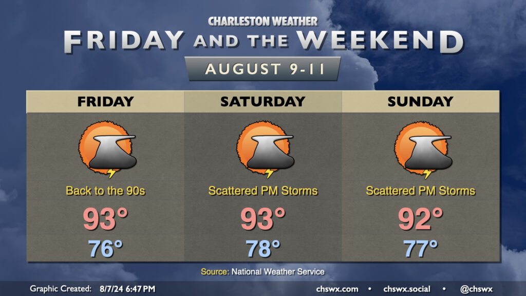
Debby will accelerate northeastward as it’s pushed away by a trough in the Northeast, sending us back to more typical summertime weather as we get into Friday and the weekend. The 90s return along with 105°+ heat indices. We’ll see scattered thunderstorms along and ahead of the seabreeze each afternoon especially as the atmosphere remains fairly moist in the wake of Debby. An isolated severe storm can never be ruled out in this scenario, but heavy rain in the wrong places could make for temporary setbacks in recovering from what will undoubtedly be some long-duration flooding.
The good news is that there’s nothing else that looks like it’ll be a concern for us in the tropics right now. As always, we’ll keep watch as we are on the cusp of the climatological peak of hurricane season.
Follow my Charleston Weather updates on Mastodon, Bluesky, Instagram, Facebook, or directly in a feed reader. Do you like what you see here? Please consider supporting my independent, hype-averse weather journalism and become a supporter on Patreon for a broader look at all things #chswx!