Debby is departing, but flooding remains a problem
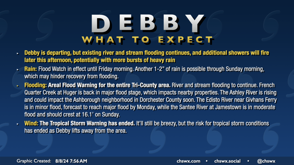
All Tropical Storm Warnings were dropped this morning as Debby, which made landfall around Bulls Bay at 2am, continues to lift north away from the area. The risk for flooding continues, especially near rivers, creeks, and streams. An Areal Flood Warning remains in effect across the entire Tri-County area through at least 2:45pm. Additional rain should develop courtesy of some wraparound moisture from Debby as we get into the heat of the day, which could inhibit recovery from flooding, so the warning continues. The Flood Watch continues until Friday morning as well.
Temperatures today will run in the upper 80s, closer to normal after a record cool high temperature of 80° on Wednesday. We’ve seen some peeks of sun and blue sky this morning and should hopefully see a bit more of that just for our spirits’ sake. The sun will make a more complete comeback for Friday and the weekend.
Additional tornadoes confirmed
The National Weather Service’s survey teams have confirmed three additional tornadoes in the Charleston area from Monday night’s rain bands: an additional EF-1 tornado on Edisto Beach, an EF-1 tornado on Isle of Palms, and an EF-0 tornado in West Ashley. This brings the tornado count to seven from Debby, six of which occurred in the Charleston area. Expand the sections below for the survey reports from the National Weather Service.
Edisto Beach South
Rating:                 EF1
Estimated Peak Wind:    90 mph
Path Length /statute/:  0.56 miles
Path Width /maximum/:   100 yards
Fatalities:             0
Injuries:               0

Start Date:             08/05/2024
Start Time:             10:08 PM EDT
Start Location:         6 SSW Edisto Island /  / SC
Start Lat/Lon:          32.479 / -80.3307

End Date:               08/05/2024
End Time:               10:11 PM EDT
End Location:           6 SSW Edisto Island / Colleton County / SC
End Lat/Lon:            32.4844 / -80.3378

Survey Summary:
A brief tornado, associated with an outer rain band from Tropical
Storm Debby, moved onshore at the south end of Edisto Island near
the 2700 block of Point Street, where it snapped and twisted some
small trees and removed asphalt shingles to at least one home.
The worst damage was on Palmetto Blvd, where one home had a
complete collapse of the porch and a significant portion of the
roof removed.  The tornado continued to move rapidly
northwestward crossing around the 2700 block of Myrtle Street,
where it did some minor damage to the facia of at least one home.
Just northwest, near the 2900 block of Lee Street, at least one
home had a corner of the roof removed. The tornado then moved
into the southern portion of the Plantation Golf Course where it
dissipated.
Isle of Palms
Rating:                 EF1
Estimated Peak Wind:    87 mph
Path Length /statute/:  0.72 miles
Path Width /maximum/:   75 yards
Fatalities:             0
Injuries:               0

Start Date:             08/05/2024
Start Time:             09:33 PM EDT
Start Location:         3 WSW Wild Dunes / Charleston County / SC
Start Lat/Lon:          32.7892 / -79.7773

End Date:               08/05/2024
End Time:               09:37 PM EDT
End Location:           3 WSW Wild Dunes / Charleston County / SC
End Lat/Lon:            32.7972 / -79.785

Survey Summary:
A brief tornado, associated with an outer rain band from Tropical
Storm Debby, moved onshore near 25th Ave where it did minor roof
damage to one house and also pulled the front door out the frame.
It continued north-northwest along 25th Ave, between Palm Blvd
and Hartnett Blvd it pulled out a few windows and snapped and
uprooted some trees. As it moved just north of Hartnett Blvd, it
removed the shingles from a portion of the roofs from a few
homes. Beyond this point, the tornado curved a bit more northwest
and snapped a few more trees and it began lifting near Waterway
Blvd and 24th Ave. The tornado continued northwest and dissipated
within the Intra Coastal Waterway. Overall, an estimated 29 homes
sustained some level of damage, either directly by the tornado or
from trees or large limbs falling on them.
West Ashley
Rating:                 EF0
Estimated Peak Wind:    77 mph
Path Length /statute/:  3.88 miles
Path Width /maximum/:   200 yards
Fatalities:             0
Injuries:               0

Start Date:             08/06/2024
Start Time:             12:14 AM EDT
Start Location:         Citadel Mall / Charleston County / SC
Start Lat/Lon:          32.8 / -80.035

End Date:               08/06/2024
End Time:               12:22 AM EDT
End Location:           Shadowmoss / Charleston County / SC
End Lat/Lon:            32.8432 / -80.0765

Survey Summary:
A tornado, associated with an outer band from Tropical Storm Debby, began near the Citadel Mall and I-526, where small limb debris found across I-526. The tornado is suspected to have sporadically touched down as it continued northwest across a mostly uninhabited area along Henry Tecklenburg Dr, just
south of Bon Secours St. Francis Hospital. It then continued northwest across Glenn McConnell Pkwy where it snapped and uprooted some trees as it move near Bairds Cv and Mary Ader Ave.  The tornado then crossed a marshy area of Long Branch Creek, and snapped and uprooted a few more trees around Wicklowe Drive. It continued northwest, south of Canterbury Woods over a heavily wooded area, and crossed Bees Ferry Road. The tornado then tracked down the southern end of Shadowmoss Plantation Golf Club, where it snapped and uprooted a few more trees between Brogun Ln, McDougall Dr and Dunvegan Dr. The tornado dissipated just south of Muirfield Pkwy, just northwest of the Shadowmoss clubhouse.
Sinkhole opens on Romney St.
A sinkhole opened up last night on Romney St. between King and Meeting on the Charleston peninsula. It’s not clear how deep the sinkhole is yet, but we may see additional cases like this over the next couple days. Even though the storm is leaving, it’s important to stay out of floodwater. Never drive around a barricaded road!
I’ll have your Friday and the weekend forecast tonight; spoiler alert: still a bit stormy, but there’s some sun in there, too. (And heat advisories, alas.)
Follow my Charleston Weather updates on Mastodon, Bluesky, Instagram, Facebook, or directly in a feed reader. Do you like what you see here? Please consider supporting my independent, hype-averse weather journalism and become a supporter on Patreon for a broader look at all things #chswx!