Weekend forecast: Nasty heat, afternoon storms, flooding continues
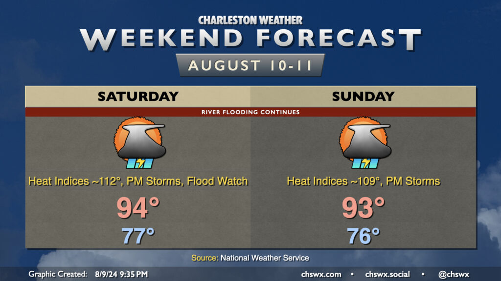
The first weekend after Debby will be a sweltering hot and occasionally unsettled affair as a front stalls out to our west and the seabreeze helps to kick off afternoon showers and thunderstorms. Expect to start Saturday in the upper 70s, warming to the mid-90s in the afternoon. Lingering tropical moisture characterized by dewpoints in the upper 70s will drive heat indices into dangerous territory well into the low 110s. We could flirt with Excessive Heat Warning criteria if it wasn’t for the expectation that showers and thunderstorms would fire on the seabreeze by midafternoon. Unfortunately, we may see yet another round of heavy downpours for places being impacted by the ongoing flooding in the wake of Debby, and so it appears the Flood Watch will continue through at least 10am Saturday. Folks around Ridgeville, Moncks Corner, and Huger will need to continue to monitor for possible Flash Flood Warnings. We should see another round of showers and storms fire on Sunday with a similar setup in place to Saturday, too. Air temperatures may be slightly lower, but heat indices will still run close to 110°, so we will continue to swelter throughout the day Sunday. A front will squeak through next week, though, and that should allow for a little bit cooler and slightly drier air (72° dewpoints vs. 78° dewpoints, so don’t get too excited) to get into the area. So, it won’t last forever. Hang in there.