The week ahead: Post-Debby flooding continues, but not as rainy
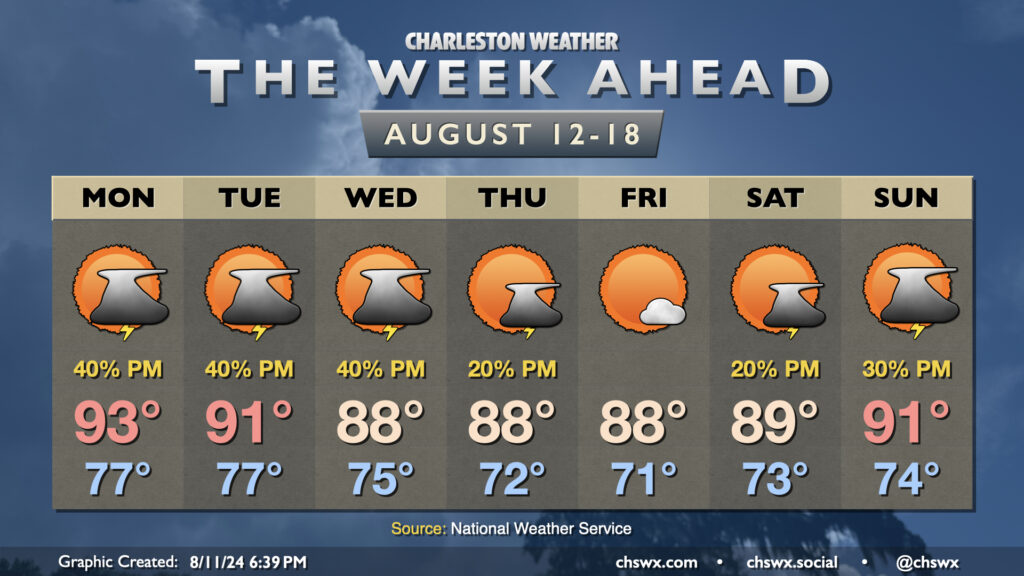
Well, there will be decidedly fewer tropical cyclones impacting the area during the upcoming week, though we will still be living with flooding from Debby for the next few days along the Edisto and Ashley rivers as they continue to fall slowly from record (or very near-record) levels. We at least have something to look forward to as we head into the first school week of the year: some drier air punching in for late week.
Stop me if you’ve heard this: We start the week on the warm and muggy side. Lows in the upper 70s will yield to highs in the low to mid-90s in the afternoon on Monday, with heat indices being driven back into the mid-100s once again. Scattered thunderstorms will be possible once again in the afternoon, driven by the increasingly diffuse front that’s stalled nearby and the inland penetration of the seabreeze. Slow-moving thunderstorms will remain a concern, especially for areas in Dorchester and Berkeley counties still contending with flooding.
A backdoor front approaches the area on Tuesday as Berkeley and Charleston go back to school. Showers and thunderstorms in the afternoon will generally be driven by the seabreeze, though coverage may be lower. Air temperatures don’t peak quite as high, either — generally expect low 90s with a touch of drier air working into the area to keep the heat index capped around 100°.
The aforementioned front should clear the area by Wednesday morning, though a lingering trough will keep shower and storm chances in play for the afternoon. Once again, though, coverage should be a little lower as some drier air begins to work its way into the area. Lows in the mid-70s yield to highs “only” in the upper 80s in the afternoon.
The drier air should make a good southward push on Thursday, yielding a cooler start in the low 70s, lower dewpoints (upper 60s), and highs topping out once again in the upper 80s under mostly sunny skies for Dorchester’s first day back to school with just a slight chance of an afternoon thunderstorm. The respite continues Friday, which could be the nicest weather day in recent memory with few clouds, reasonable dewpoints, and temperatures in the upper 80s. Heading into the weekend, moisture will gradually return to the area as high pressure slips off to the east. Saturday still looks alright with just a slight chance of a storm in the afternoon, but heat and humidity will climb back in a bit more for next Sunday, with slightly increased afternoon thunderstorm chances as well. Still, it will be a far cry from the sweltering we’ve been in lately.
River flooding update
River flooding will continue to be a significant issue for communities along the Edisto and Ashley River in Colleton and Dorchester counties during the upcoming week. Areal Flood Warnings for Dorchester and Berkeley counties continue through at least 9:45am, with further extensions likely for the foreseeable future.
Edisto River near Givhans Ferry

After a crest at 17.21′, the highest since 1945 and the third-highest on record, the Edisto River at Givhans Ferry will slowly fall as we head into the upcoming week. However, it remains in major flood stage and should stay that way through Thursday morning, prolonging significant flooding impacts in this area from Givhans to Adams Run.
Ashley River at Cooke Crossroads
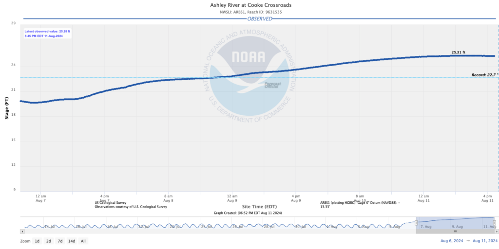
The Ashley River at Cooke Crossroads (gauge location right off Bacons Bridge Road just past Highway 61) remains at record levels. At 6:45 PM on August 11, the river was at 25.3′ after a brief peak at 25.31′. The record of 22.7′, set during the October 2015 flooding event, has been completely obliterated. This has caused flooding in the Ashborough neighborhood in Summerville, and closed off Bacons Bridge Road from Highway 61 in both directions. There are no forecasts for this particular gauge, though we should continue to see flooding be a concern for several more days. In fact, there’s so much freshwater that it is overwhelming the tidal influence here.
Santee River at Jamestown
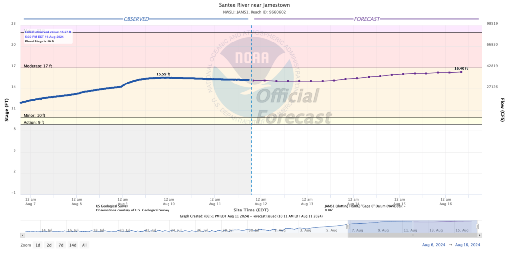
The Santee River near Jamestown remains well into minor flood stage, on the verge of reaching moderate flood stage later this week. There were comparatively fewer impacts for this river basin given the heaviest rain generally fell over the Edisto and Ashley basins, but problems could begin for folks around Harris Landing Road once the gauge hits 16′ according to NWS and NOAA.
Potential Tropical Cyclone Five (future Ernesto) forms; no concerns for the Lowcountry

The National Hurricane Center has started writing advisories for Potential Tropical Cyclone Five, which is around 875 miles ESE of Antigua as of the 8PM intermediate advisory. Tropical Storm Watches are up for Guadalupe and the Virgin Islands, and are certainly possible for Puerto Rico as we get into the next couple days, hence the need for NHC to begin advisories. It’s worth noting that the storm has not yet formed, but by late Monday into early Tuesday, a tropical storm is expected to develop. Provided nothing unexpected pops up, it will be named Ernesto.
As of the 5PM forecast, the storm will move across the Lesser Antilles, strengthening as it goes. It should be a hurricane by Wednesday afternoon as it begins a northward turn in response to a trough that’ll be moving off the East Coast. There’s a decent shot it may become a major hurricane, and folks in Bermuda may be dealing with this next weekend.
It’s early in the game, but there is no evidence to this point that suggests Five/future Ernesto poses a risk to the Lowcountry — welcome news as we continue to recover from Debby.
Thank you for your support!
Finally, I wanted to take a moment to thank many of you in the community who have sent donations, Patreon signups, or just shared what I’m doing leading up to and during Debby. There’s a lot of new folks following along as a result (welcome!) and that is always super-cool to see. Simply put, none of this works without y’all, and I am incredibly appreciative of all the support time and time again over the past 16+ years. Here’s to hoping to quieter skies ahead…
Follow my Charleston Weather updates on Mastodon, Bluesky, Instagram, Facebook, or directly in a feed reader. Do you like what you see here? Please consider supporting my independent, hype-averse weather journalism and become a supporter on Patreon for a broader look at all things #chswx!