Rest of the work week: A little bit of drier air as rivers slowly fall
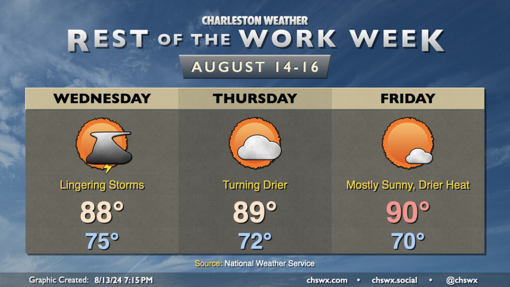
We have a bit of a respite from the rain and the extreme humidity on the way as a front slides south of the area and stalls tonight. Some lingering moisture and a trough of low pressure will allow for a few storms to remain in the forecast on Wednesday, though, as dewpoints slowly drop through the low 70s throughout the day. We start the day in the mid-70s and warm to the upper 80s in the afternoon, capped by some of that cooler and drier air trying to move back in. Expect the best chance of showers and storms from roughly 2-10PM. A few downpours can’t be totally ruled out as the deeper moisture only really starts to scour out Wednesday night, so a flood advisory or two could still be possible.
Thursday and Friday will be the first quiet weather days in what feels like forever. The front nudges further south overnight, and cooler and drier air filters in behind it. Lows on Thursday run in the low 70s, warming to the upper 80s under partly cloudy skies. Friday looks even better: we start the day right around 70°, with some 60s lows not out of the question further inland and in rural areas. We’ll warm to around 90° under mostly sunny skies, with dewpoints mixing down to about the mid-60s in the afternoon. It’s not October crisp by any stretch of the imagination, but it represents tangible improvement over the past couple weeks. A warming and humidifying trend starts back up for the weekend, though we should get Saturday in rain-free before a slight chance of storms on Sunday.
Flooding update
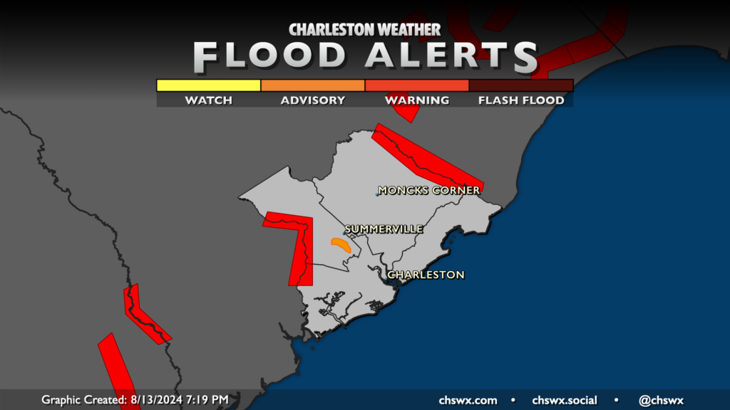
Flood warnings and advisories continue around the Edisto, Ashley, and Santee rivers as runoff from Debby continues to cause problems. Flood Warnings are out for the Edisto River near Givhans Ferry and the Santee River near Jamestown, while a Flood Advisory remains in effect for neighborhoods along the Ashley in Summerville.
Edisto River near Givhans Ferry
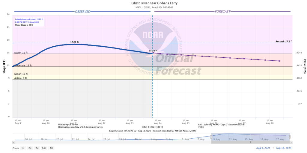
The Edisto near Givhans is still in major flood stage, but is forecast to fall into moderate flood by tomorrow as the water level continues to fall. Heavy rain in this area earlier Tuesday may have slowed the descent slightly, but the downward trend will be uninterrupted with a few days of rain-free weather. Slow recession of the water level is forecast through the weekend.
Ashley River near Cooke Crossroads
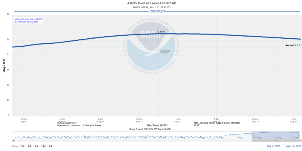
The Ashley remains above its previous record of 22.7′ set during the October 2015 flood event, but is on a downward trend as well after a crest at 25.31′ on Sunday. Flooding continues in the Ashborough neighborhood and should continue for a few more days as the river gradually falls. Expect the Flood Advisory for this area to be renewed at 9:45am Wednesday.
Santee River near Jamestown
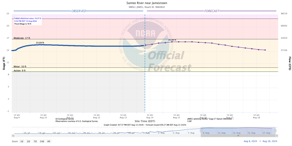
The Santee River near Jamestown remains in minor flood and will stay there with a bit of a rise expected over the next couple days before finally starting a sustained fall over the weekend. The current crest is expected to be around 16.3′, just shy of the moderate flood threshold of 17′. Reports of issues from here are sparse, but if you have eyes on the ground here, I’d love to know what’s happening.
Tropics: Ernesto strengthens, but still not an issue locally
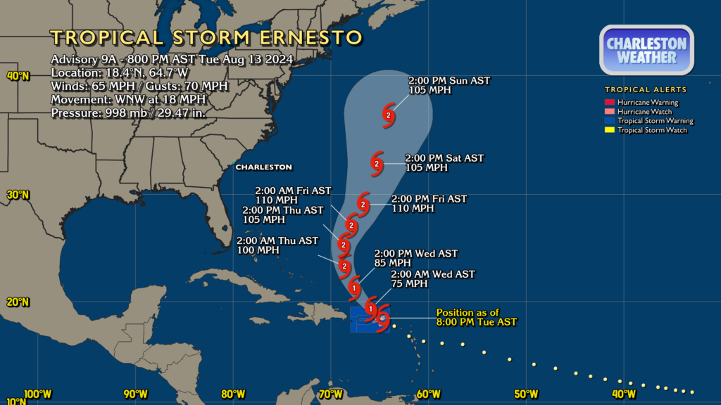
Ernesto is continuing to strengthen as it reaches Puerto Rico, with tropical storm conditions expected there tonight. At 8PM, it had 65 MPH winds with gusts to 70 MPH and was moving WNW at 18 MPH. Pressure continues to fall, with the minimum pressure down to 998mb at 8PM from 1001mb at 5PM, indicating the continued strengthening.
A turn more northwest and then north is expected over the next couple days, with a bit of an easterly jog to that northward motion expected thereafter. Ernesto remains no threat to the Lowcountry, though some swell could arrive over the weekend at the beaches, increasing the rip current risk.
Elsewhere in the tropics, NHC doesn’t expect anything new to form within the next week. Enjoy the respite — climatologically speaking, the basin should get a little busier over the coming weeks.
Follow my Charleston Weather updates on Mastodon, Bluesky, Instagram, Facebook, or directly in a feed reader. Do you like what you see here? Please consider supporting my independent, hype-averse weather journalism and become a supporter on Patreon for a broader look at all things #chswx!