Friday & the weekend: Showers return; watching low pressure offshore
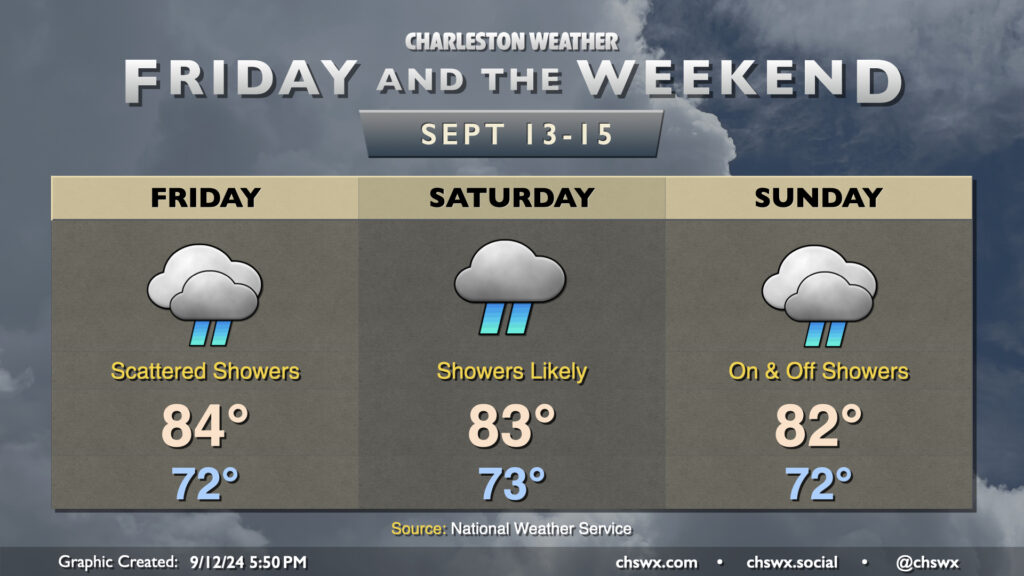
Showers will make a return to the forecast for Friday and the weekend as the dry air that’s been hanging on continues to erode. Models have been trending a bit drier for Friday, but scattered showers still appear to be a decent bet as lift improves atop the wedge of high pressure that remains in place, though it does look like the heaviest rain remains closer to the stationary front to our southwest. Temperatures start in the low 70s, warming to the mid-80s in the afternoon under predominantly cloudy skies, though some peeks of sun are possible from time to time.
The weekend forecast turns a little lower-confidence as we watch for the potential for low pressure to spin up offshore on Sunday. Saturday, meanwhile, continues to look showery at times with the risk for a few rumbles of thunder as well as energy aloft interacts with a developing coastal trough. Temperatures generally run in the low 70s to start with highs in the low-to-mid-80s once again in the afternoon.
Sunday’s forecast could turn a bit on if and where low pressure spins up. For now, expect essentially a repeat of Saturday, with temperatures running in the low 70s to start the day, heading into the low 80s in the afternoon. A faster and more southerly low pressure system could increase the risk of heavy rain in the area later Sunday. Guidance is still a little split on where and when low pressure ultimately develops, but the general expectation is that it spins up offshore by Monday, trekking northwestward and reaching shore by Tuesday, with heavier rain on the northern side of the low. It’s hard to know right now if it will shed its fronts and turn tropical, but the Hurricane Center pegs the area of concern at a 30% chance (low risk) to develop over the next seven days. We’ll keep an eye on this, and you probably should as well, though it still doesn’t look like anything that develops will have much of a chance to get particularly strong.
Coastal flood risk increases starting Friday evening
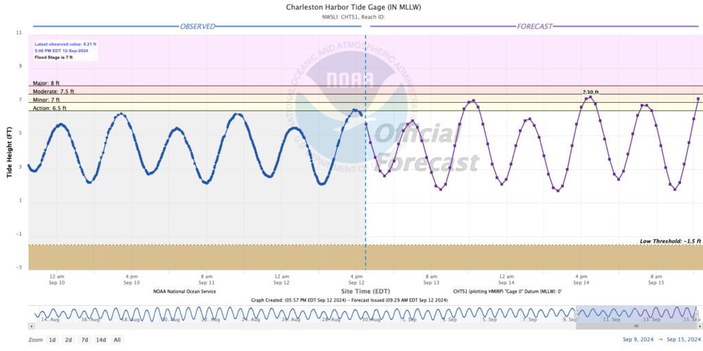
Persistent northeasterly winds and an upcoming full moon at perigee will bring us a round of tidal flooding each evening beginning with high tide around 4:30 PM Friday. Right now the coastal flooding forecast is generally for minor flooding through Saturday, though the development and track of the aforementioned low pressure system will have impacts on the tidal forecast heading into Sunday and early next week. Stay tuned for updates!
Follow my Charleston Weather updates on Mastodon, Bluesky, Instagram, Facebook, or directly in a feed reader. Do you like what you see here? Please consider supporting my independent, hype-averse weather journalism and become a supporter on Patreon for a broader look at all things #chswx!