Helene update: Tropical Storm Watch issued
A Tropical Storm Watch is now in effect for the Lowcountry, including the Charleston Tri-County area, as Helene continues to organize and strengthen while it moves northward into the Gulf.
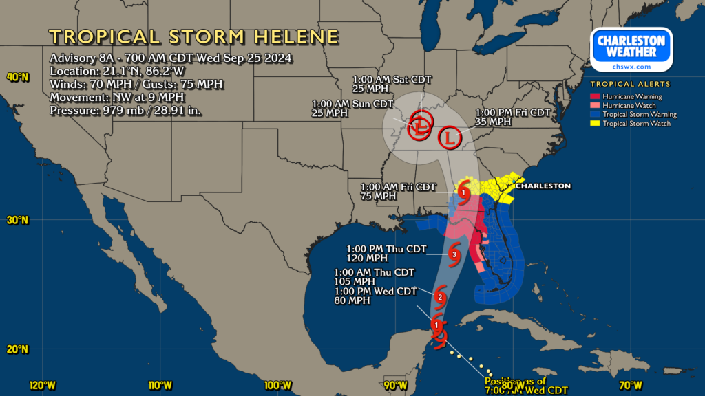
As of the 8AM intermediate advisory, Helene has winds of 70 MPH and is moving NW at 9 MPH, with a turn even more northward expected today as it becomes a hurricane. Rapid intensification is expected to take place during the day Thursday, with it making landfall as a major hurricane late Thursday on the Big Bend of Florida. It will be moving quickly, which will push hurricane impacts well inland into Georgia before it starts to wind down and accelerate north and northwestward on Friday as an upper low captures it.
Helene will be a large storm, with its wind field expanding as it moves northward. The track is almost irrelevant to our interests here at this point; there will be wobbles east and west, but there’s no indication that anything will shift so radically that it will have a material change on our impacts.
Impacts for the Charleston area
Rain & surge
As mentioned last night, we should expect deteriorating conditions on Thursday as rain bands move into the area around Helene’s sprawling circulation. Periods of heavy rain will be possible, but the forward speed of the storm and the general consensus that its heavy rain shield stays to our west will keep our rain totals into the 1-3″ range, highest inland. That’s still a good bit of rain, but (mercifully) is a far cry from what some of us experienced during Debby. Still, periods of flooding cannot be ruled out, especially as we will deal with a bit of surge from this one; minor salt water flooding is expected Thursday afternoon with tides approaching 7.3′ around 4PM. This will have impacts on the usual trouble spots in downtown Charleston.
Tornadoes
The tornado threat continues to be worth watching; modeling continues to show a well-sheared and moderately unstable atmosphere on the east side of the storm throughout the day Thursday and into Thursday night. It may be a long day and night depending on the progression of rain bands, with the tornado threat seeming to kick up by midday and lasting into early Friday morning. Today’s a good day to check your weather alerting devices to make sure things are working and can wake you up.
Winds
Gusty winds will be a factor with Helene, but the core of its strongest winds remain to the west. Still, we could see some gusts pushing 40 MPH at times, especially at the coast and within stronger rain bands. Power outages are possible, so be sure you’re good on your battery-powered items. Disable charge limiters on your phones tomorrow, too — some newer phones let you govern how high you top off the battery for longevity purposes. This is one of those days where you’ll want to make sure you have the full capacity available to you.
Next update
The next NHC update comes out at 11am. I expect Tropical Storm Warnings at some point today, so keep an ear out for those as well. My next post should be around 5-6pm.
I’ll be joining Carolina Weather Group this evening around 9pm for a roundtable discussion on what to expect here as well as the rest of the Carolinas. Please tune in!
Follow my Charleston Weather updates on Mastodon, Bluesky, Instagram, Facebook, or directly in a feed reader. Do you like what you see here? Please consider supporting my independent, hype-averse weather journalism and become a supporter on Patreon for a broader look at all things #chswx!