Helene in the Lowcountry: Tornado Watch issued
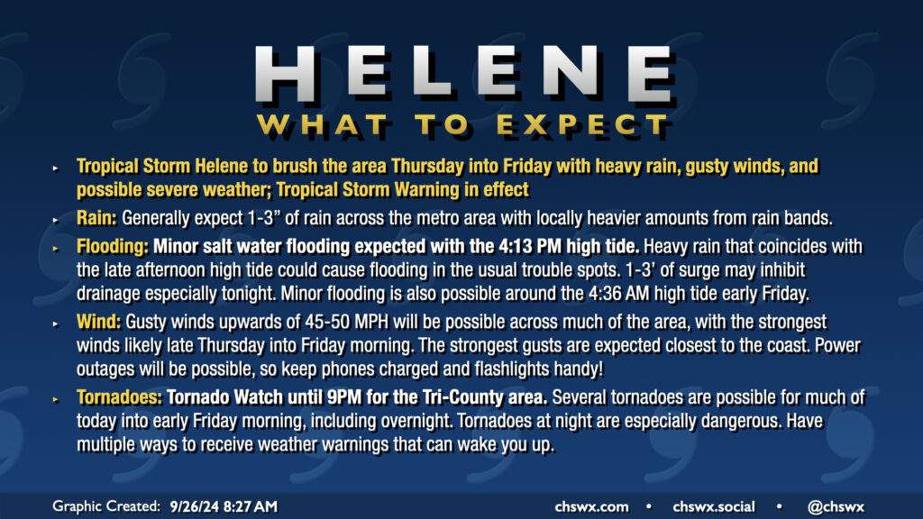
A potentially busy weather day awaits as Hurricane Helene strengthens again on approach to landfall late tonight on the Big Bend of Florida. A Tornado Watch is now in effect until at least 9PM, though I expect this to be extended overnight, as conditions continue to improve for the development of tornadoes. There has already been one tornado warning this morning in Beaufort County, likely with more to come. Tornadoes are the main concern with Helene, though heavy rain and gusty winds could still cause flooding and power outage issues.
Helene strengthening again
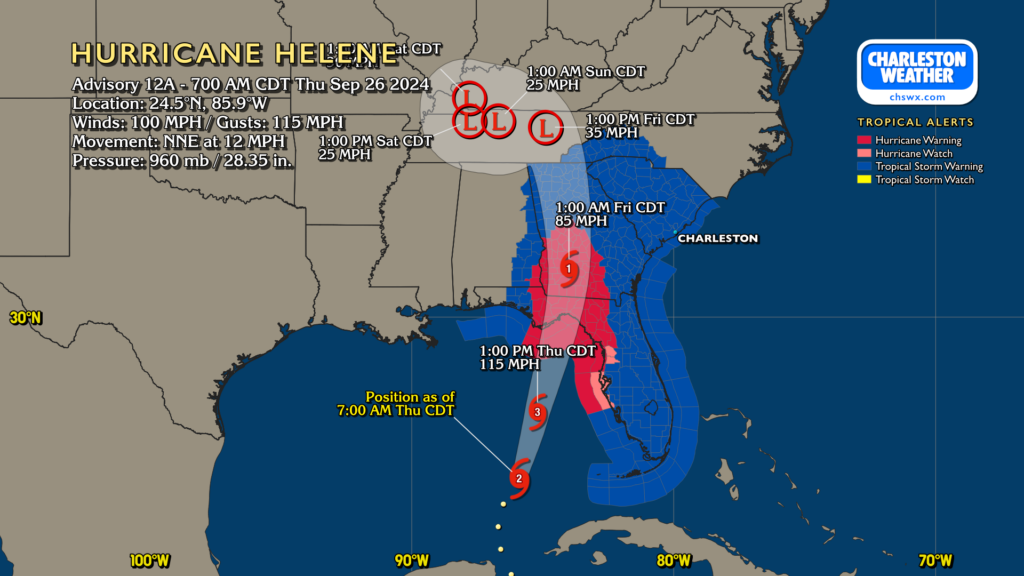
As of the 8am intermediate advisory, Helene is now a Category 2 hurricane on the Saffir-Simpson Wind Scale, moving NNE at 12 MPH with 100 MPH maximum sustained winds. It’s expected to continue to strengthen into a major hurricane before landfall on the Big Bend of Florida later tonight. It will be moving very quickly, and hurricane impacts will extend well inland into much of Georgia. Tropical Storm Warnings are up for the entire state of South Carolina as Helene’s wide wind field will bring the risk for tropical storm conditions state-wide. The fast forward motion is going to be a big contributor to the tornado threat, but will also help get Helene out of here fairly quickly, with improving conditions expected Friday.
Impacts for the Charleston area
Rain & surge
Conditions will continue to deteriorate today as Helene moves northward and rain bands begin to move in. Flooding will be a more isolated issue than we saw with, say, Debby, as rain totals should top out only around 1-3″, highest inland. That being said, periods of flooding cannot be ruled out, especially as we will deal with a bit of surge from this one; minor salt water flooding is expected Thursday afternoon with tides approaching 7.3′ around 4PM. This will have impacts on the usual trouble spots in downtown Charleston. If rain coincides with this tide (which is a distinct possibility), more widespread flooding concerns can be expected. Surge effects should also persist overnight, with minor salt water flooding expected around the 4:36 AM high tide early Friday.
Tornadoes
A tornado watch is now in effect until at least 9PM, though I fully expect that to be extended well into overnight. There has already been one tornado warning in Beaufort County early this morning, with numerous storms showing signs of some rotation to our southwest. The tornado threat should escalate locally in the late morning hours, and peak after dark. Remember, tropical tornadoes can develop with little or no warning and tend to move very, very quickly, which is especially dangerous at night. Know where you will go in case of a warning before you have to go — choose an interior room on the lowest floor of your home, putting as many walls between you and the outside as possible.
Winds
Gusty winds will be a factor with Helene, but the core of its strongest winds remain to the west. Still, we could see some gusts pushing 50 MPH at times, especially at the coast and within stronger rain bands. Power outages are possible, so be sure you’re good on your battery-powered items. Disable charge limiters on your phones, too — some newer phones let you govern how high you top off the battery for longevity purposes. This is one of those situations where you’ll want to make sure you have the full capacity available to you. Be ready for power to be out for a little while, too, especially if winds come in a little stronger than forecast or a tornado affects your area.
Next update & streaming schedule
The next full NHC track and intensity forecast update drops at 11AM, though at this point, I’m worried less about those updates and more focused on local impacts. I fully expect a long night of severe weather streaming beginning around 6PM on Carolina Weather Group as well, so be sure to tune in as we navigate what could be a busy day and night of severe weather. Please stay safe!
Follow my Charleston Weather updates on Mastodon, Bluesky, Instagram, Facebook, or directly in a feed reader. Do you like what you see here? Please consider supporting my independent, hype-averse weather journalism and become a supporter on Patreon for a broader look at all things #chswx!