The week ahead: Cooling off — and watching Milton
A cold front brings a shot of Fall to the area as we get into the meat of the new week with a possible brief appearance by Hurricane Milton as it departs into the Atlantic and turns extratropical.
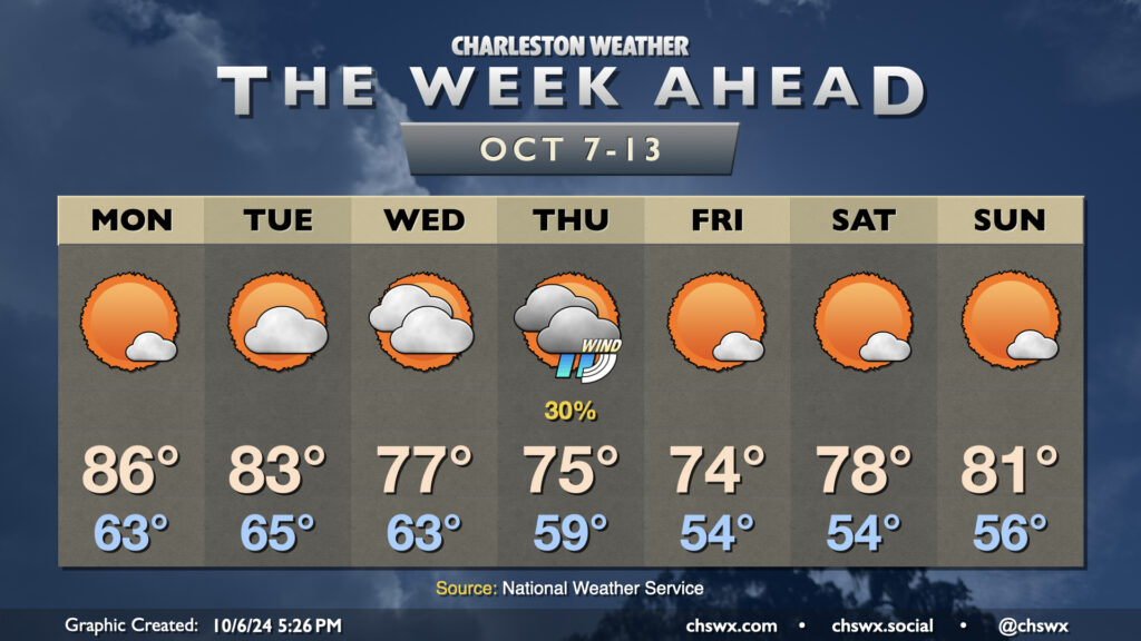
Monday will be the warmest day of the week ahead of the aforementioned cold front. We’ll start the day in the low to mid-60s, which is right around where we should be at this point in the year. Temperatures will warm to the mid-80s in the afternoon under mostly sunny skies.
The front gets through Tuesday morning. We’ll start Tuesday in the mid-60s, but will only warm to the low 80s in the afternoon with a bit more in the way of cloud cover as the front stalls out to our south. Cloud cover and northeasterly winds increase Wednesday as Milton draws closer. This will keep highs only in the mid-to-upper 70s in the afternoon.
On the current forecast track, we can expect peripheral effects from Milton starting Wednesday night and peaking on Thursday. Showers will be possible near the coast, but the main concerns will be gusty winds as the gradient pinches between Milton to the south and high pressure to the north, rough surf and rip currents, maybe some beach erosion, and coastal flooding, which may be significant come Thursday. It’s too early to know the extent of those impacts, but it’ll be worth watching for travel troubles downtown around times of high tide.
The good news is that Milton departs quickly, and the weekend looks excellent, with the first solid stretch of lows in the 50s of the season expected through Sunday. Temperatures warm from the mid-70s on Friday to the low 80s on Sunday with plenty of sunshine expected.