The week ahead: Quiet and seasonably warm weather prevails
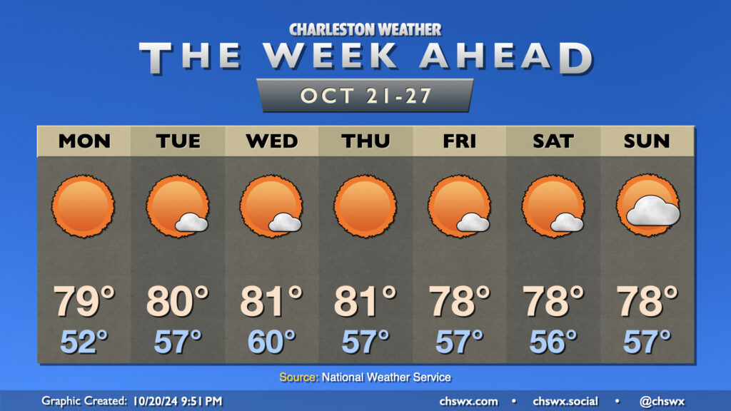
Not a whole lot to discuss this week, weather-wise. Our winning streak of quiet weather continues for next week as high pressure remains the dominant feature across the eastern US. Temperatures will generally run a little above normal each afternoon, heading into the upper 70s to low 80s each day, while clear skies at night and reasonably calm winds will help temperatures fall back toward about normal, which for this point in the year is in the mid-50s. Monday will start off a little cooler, but will rebound to near 80° in the afternoon with very few, if any, clouds to be found. A dry front brings a slightly cooler airmass to the area for the weekend, but this will only knock temperatures down a couple degrees.
Looking for rain? Not much to be found in the seven-day, as you can see. Offshore shower activity mid-week should stay there with high pressure in place on land. It may be next week before we get some showers back into the picture based on some of the longer-range models, but even then it doesn’t look like we will get much, if any. We are getting into a climatologically drier period of the year — in fact, November is typically the driest month of the year. Still, we’re running about a 2″+ surplus thanks to Debby back in August.
Finally, this most recent round of coastal flooding concludes with Monday’s midday high tide, when water levels should peak around 7.1-7.3′ in the harbor, causing some salt water flooding a couple hours on each side of the 11:47 AM high tide. From there, expect high tides to stay below flood stage for at least the rest of this week as we head into the third quarter phase on Thursday.