The week ahead: First significant rainfall in over a month possible

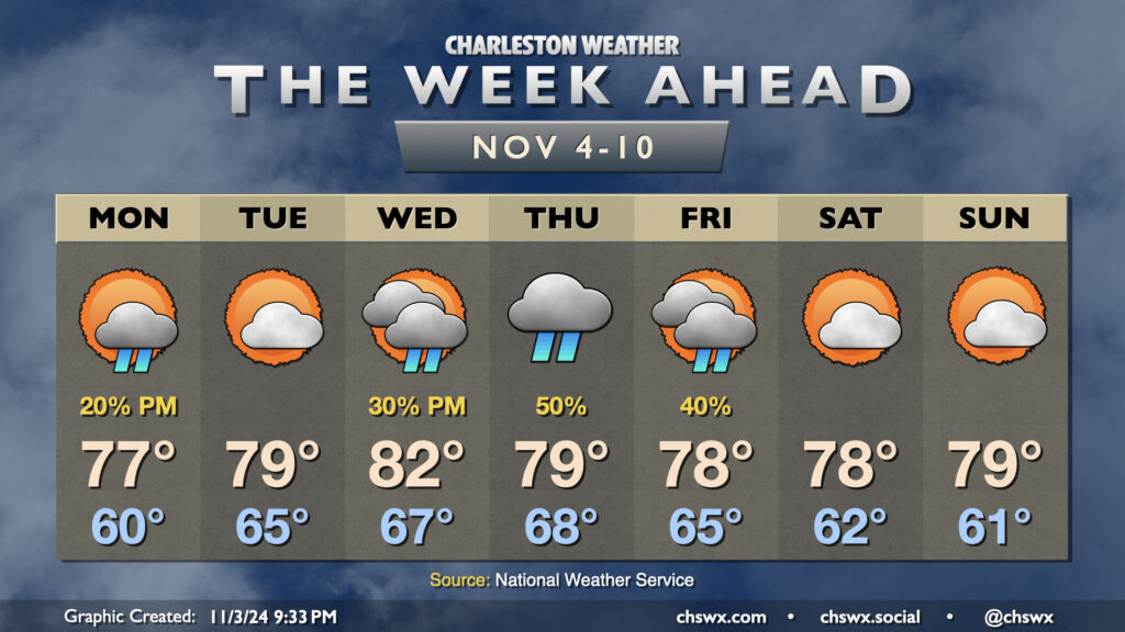
The main story of the upcoming week of weather will be the potential for some actually measurable rainfall especially as we get into midweek. Temperatures will remain above normal, though, in a blow to sweater weather fans across the Lowcountry.
Monday starts around 60° as the wedge of high pressure that built in on Sunday keeps things a little cooler in the morning. A coastal trough will begin to trek inland later in the day as high pressure anchored to the northeast shoves a little more eastward, and this could spread some showers into the Lowcountry for the second half of the day. Rain chances remain on the low end, though.
We start to turn warmer Tuesday as high pressure continues to slip eastward into the Atlantic. We’ll get the day in largely rain-free with a mix of sun and clouds, so weather-related issues shouldn’t be a hindrance to getting out to vote if you haven’t already done so. Lows in the mid-60s — well above normal for early November to the tune of 15° — warm to the upper 70s to around 80° in the afternoon.
We turn even warmer on Wednesday, with lows in the mid-to-upper 60s yielding to the low 80s in the afternoon. Moisture starts to move northward into the area as a tropical cyclone looks to move northward into the Gulf of Mexico. No direct impacts from this late-season storm are expected here in the Lowcountry, though the increase in moisture should help more widespread, much-needed rain to develop starting Wednesday evening. Rain chances peak Thursday as the coastal trough sharpens and a front approaches from the north. We’ll see the risk for rain decrease during the day Friday before what should be a quiet weekend.
Coastal flooding possible Monday morning
The only other issue could be a splash of minor coastal flooding around Monday morning’s high tide, with water levels peaking between 8-10 PM. The northeasterly wind will drive higher tidal departures for much of the week, though the astronomical tide will be waning, which should keep additional flooding at bay through Wednesday.
Follow my Charleston Weather updates on Mastodon, Bluesky, Instagram, Facebook, or directly in a feed reader. Do you like what you see here? Please consider supporting my independent, hype-averse weather journalism and become a supporter on Patreon for a broader look at all things #chswx!