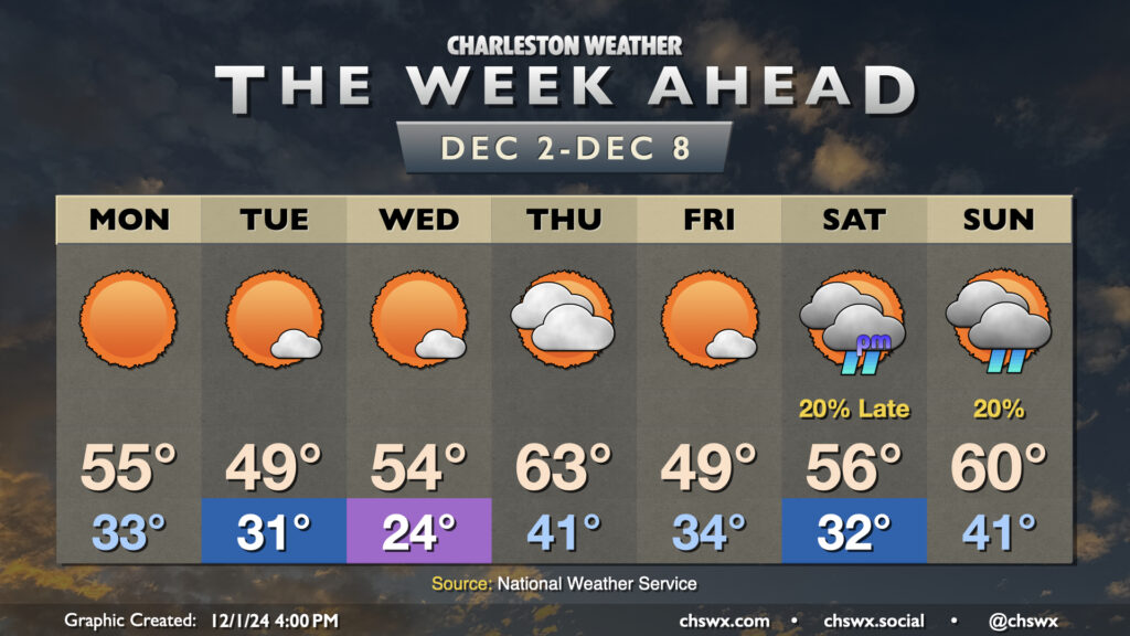
The week ahead: Below-normal temperatures continue, with a particularly cold stretch Tuesday and Wednesday

Seemingly on cue for climatological winter, temperatures will remain below normal pretty much all week, with a couple reinforcing shots of cool air to keep us honest interspersed throughout. We stay mostly rain-free, with the possible exception of later Saturday night into Sunday as another front with a few showers looks to move by.
Monday starts in the low to mid-30s — slightly “warmer” than the mid-to-upper 20s that blanketed the area away from the immediate coast Sunday morning — warming to the mid-50s in the afternoon despite another day of unfettered sunshine as one of those aforementioned shots of cooler air starts to push into the area. We’ll really start to feel it on Tuesday as we start the day around or below freezing away from the immediate coast, warming to just the upper 40s in the afternoon with just a few clouds.
The coldest night of the week looks to be Tuesday night into Wednesday morning, with lows dipping well into hard freeze territory for many of us. Generally, the metro area can expect lows in the mid-20s, with below-freezing lows looking probable almost all the way to the coast. Plants and pets will definitely need protection, and many of us should consider dripping a faucet as well to protect pipes. We do start to see a bit of a rebound with temperatures getting into Wednesday afternoon, with mid-50s highs running a few degrees warmer than what we expect on Tuesday.
The brief warming trend continues into Thursday ahead of another shot of cold air. It’s the warmest day of the set, in fact, with lows in the low 40s warming to the low to mid-60s with a mix of sun and clouds. This doesn’t last long, though, as Friday heads right back into the fridge with temperatures in the low-to-mid-30s begin the day, with highs that may once again not crack 50°.
The next front arrives over the weekend. After a start around freezing on Saturday, we’ll see temperatures warm into the mid-50s in the afternoon. There will be a slight risk for some showers beginning Saturday evening through about midday Sunday or so out ahead of the front. Sunday’s temperatures look to at least somewhat resemble early December norms with lows in the low 40s and highs in the low 60s, and the NWS model blend suggests that trend continues into the following week.
Follow my Charleston Weather updates on Mastodon, Bluesky, Instagram, Facebook, or directly in a feed reader. Do you like what you see here? Please consider supporting my independent, hype-averse weather journalism and become a supporter on Patreon for a broader look at all things #chswx!