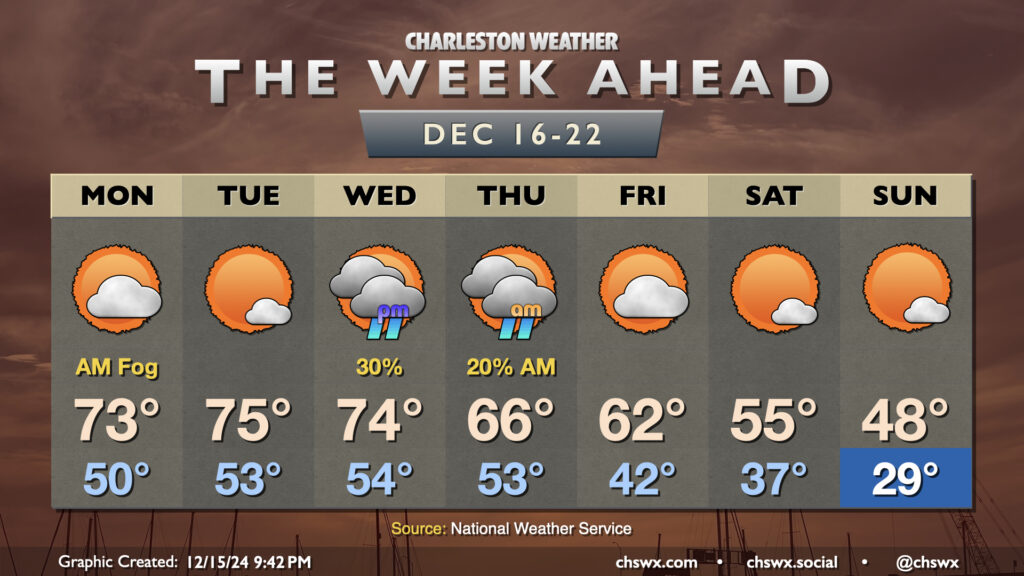
The week ahead: A warmer than normal start turns into much below-normal temperatures by the weekend

The week ahead will feature another up-and-down cycle of the temperature rollercoaster that has characterized this climatological winter so far. We start the week on the warm side, with temperatures running well above-normal through Wednesday. Monday could start a bit foggy as lows only drop to about 50°. We’ll warm to the low 70s in the afternoon under partly cloudy skies. After what could be another foggy start, expect a little reduction in cloud cover Tuesday afternoon which will lead to what should be the warmest day of the week as highs peak in the mid-70s (and maybe even a bit warmer further inland).
Changes begin on Wednesday as a cold front approaches the area. It’ll be one more warm day with highs once again peaking in the low-to-mid-70s (cooler at the coast). We should get much of the day in rain-free, with just a few showers possible beginning Wednesday evening into Thursday morning as the front moves by. Thursday starts on the mild side in the low 50s once more, but with cooler air moving in, temperatures will only peak in the mid-60s in the afternoon as clouds scour out. Temperatures on Friday will run roughly around normal under partly cloudy skies.
The bottom will fall out of the mercury over the weekend, though, especially Sunday as reinforcing Arctic air pushes into the area. Saturday starts in the upper 30s, warming to just the mid-50s in the afternoon. Sunday turns even colder, with subfreezing temperatures expected across the area (mid-to-upper 20s) with highs only peaking in the upper 40s in the afternoon despite mostly sunny skies both days.
Follow my Charleston Weather updates on Mastodon, Bluesky, Instagram, Facebook, or directly in a feed reader. Do you like what you see here? Please consider supporting my independent, hype-averse weather journalism and become a supporter on Patreon for a broader look at all things #chswx!