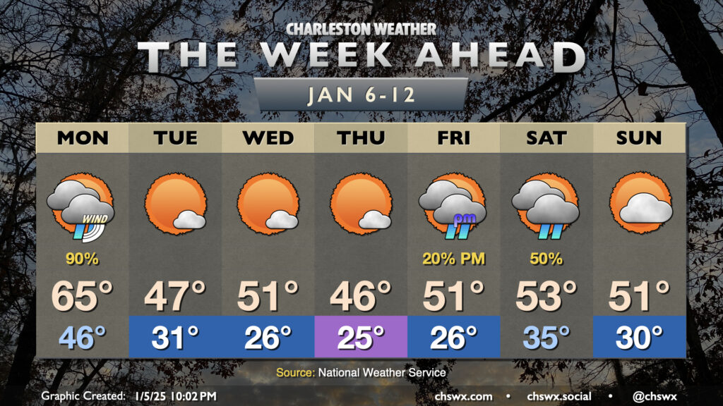
The week ahead: Windy, unsettled start leads into a chilly few days ahead of the next storm system

A chilly week ahead is bookended by two winter storm systems that will affect the area. Whether wintry precipitation gets involved remains to be seen; the probability of anything but cold rain taking place in the Charleston metro remains very low.
Monday: Windy and briefly mild with showers
First, though, we start out with a windy Monday as the first winter storm system, which is dropping a corridor of snow and ice from the Midwest into the Mid-Atlantic, moves by the area. We’ll be firmly in the warm sector of this one, with temperatures bottoming out in the mid-40s early and warming to the mid-60s ahead of a band of showers that will move by late morning/early afternoon. A rumble of thunder isn’t out of the question, but the better instability will reside south of us in Georgia, where a marginal severe risk is in place. Winds remain an issue, though, with gusts 30-35 MPH possible across much of the metro. Gusts to 40 MPH will be possible near the coast and on bridges and overpasses, which has triggered a Wind Advisory for Charleston County from 8am-4pm.
Tuesday-Thursday: Chill sets in
Once the front is through, clouds will clear out pretty quickly, and much cooler and drier air will rush into the area behind it to kick off several days of chilly weather. In fact, we should start Tuesday below the freezing mark away from the coast, warming to just the mid-to-upper 40s in the afternoon despite nearly unfettered sunshine. It’ll be a breezy day, too, which will drive wind chills into the upper 20s in the morning and keep temperatures feeling like the 30s through early afternoon. Winds die down quite a bit as we get into Tuesday evening, setting us up for a very cold Wednesday morning with lows in the mid-20s. A little bit of a northwest wind keeps the wind chills down into the low 20s. We’ll warm into the low 50s Wednesday afternoon before another shot of cold air moves in overnight, giving us another very cold day on Thursday with lows in the mid-20s yielding to highs just in the mid-40s.
Friday & the weekend: Next storm system arrives
And then we get into Friday and the weekend, which will be a complicated forecast courtesy of low pressure that will skirt along the Gulf Coast before turning northeastward Friday night into Saturday. What we do know is that while Friday will start in the mid-20s, we should warm above freezing by mid-morning. Odds favor us staying above freezing at the surface for the entirety of the storm with a warm nose aloft that looks to strengthen as we get into Saturday. Long story short, this isn’t a recipe for snow; in fact, if temperatures near the ground run below freezing with a warm nose aloft, we’re talking sleet or freezing rain. (Yuck.) There’s a lot of variability still from model run to model run, and there are several pieces that will need to come together to get a high-confidence forecast for this weekend. Right now, though, I’m favoring us staying out of the wintry stuff (though it may get close!) Stay tuned this week as this forecast will undoubtedly be refined.
Follow my Charleston Weather updates on Mastodon, Bluesky, Instagram, Facebook, or directly in a feed reader. Do you like what you see here? Please consider supporting my independent, hype-averse weather journalism and become a supporter on Patreon for a broader look at all things #chswx!