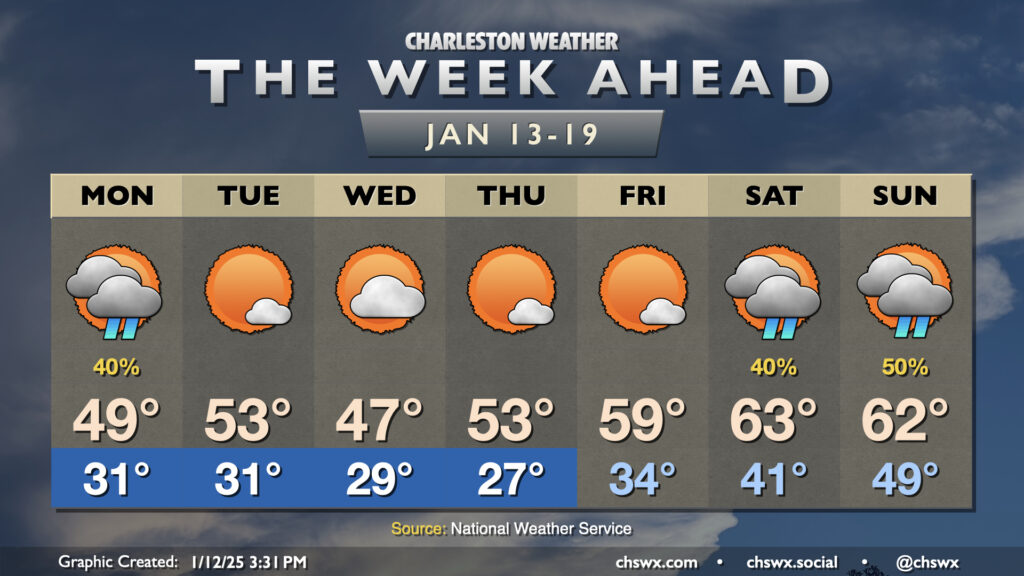
The week ahead: A little rain Monday, then mostly quiet — and chilly — until the weekend

Below-normal temperatures will continue for much of the upcoming week before a bit of a reprieve over the weekend (albeit with rain).
But first, we deal with another round of low pressure coming out of the Gulf on Monday. This stays to the south, and we won’t quite have as much cold air locked in, so chilly showers are in the forecast primarily from midday through early evening. We do start slightly below freezing, but temperatures will warm into the upper 40s — a bit chilly, to be sure, but far from cold enough to deal with any precipitation type issues, unlike Friday.
From there, we have a stretch of a few days of relatively quiet but still chilly weather featuring below-normal temperatures. We’ll have lows below freezing each day through Thursday, especially as a reinforcing cold front comes through late Tuesday/early Wednesday. Highs top out in the low 50s Tuesday and Thursday, with temperatures struggling to the mid-to-upper 40s on Wednesday in the wake of the front.
The next storm system starts to get close on Friday, and with that we’ll start to notice a bit of a warmup. Lows will be above freezing, and highs will get close to 60° on Friday. The weekend turns even warmer, with temperatures at or even a touch above normal, but also with decent shower chances as a front swings through.
Follow my Charleston Weather updates on Mastodon, Bluesky, Instagram, Facebook, or directly in a feed reader. Do you like what you see here? Please consider supporting my independent, hype-averse weather journalism and become a supporter on Patreon for a broader look at all things #chswx!