Rest of the work week: A bit warmer Wednesday, stormy Thursday, cooler Friday
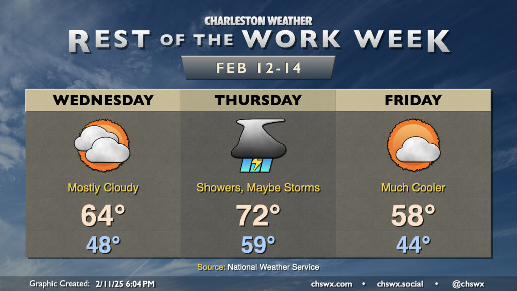
The temperature rollercoaster takes another upswing Wednesday and Thursday before dipping again Friday as a series of fronts affect the area.
Astute @chswx readers will note that Wednesday’s forecast high is about 10° cooler than the 74° that was advertised yesterday. High-resolution model guidance is strongly suggestive that the wedge front will take longer to move northward across the area as a warm front than previously thought. In fact, there’s some indications that it may stall out right across the Tri-County for a time, which certainly makes for a tricky temperature forecast. Right now, the going forecast is the mid-60s with mostly cloudy skies expected.
The warm front will get pulled north of the area late Wednesday into early Thursday, which sets up a morning low just shy of 60°. (The normal high for February 13 is 63°.) Temperatures will head into the low 70s in the afternoon as a cold front pushes toward the area. Guidance is increasingly in agreement that this front should be accompanied by a line of showers and even a few thunderstorms that would affect the area most likely in the early afternoon to early evening timeframe. Brief heavy rain is possible, with about a half-inch or so of rain expected.
Once this cold front sweeps through, it’ll stall offshore, but far enough away to where skies will clear and Friday will turn much cooler. Expect lows in the mid-40s to yield to just the upper 50s in the afternoon despite generally partly cloudy skies.
Looking ahead: Another strong front knocks temperatures back down for next week
This drop in temperature will be short-lived, though, as the front lifts back north of the area as a warm front on Saturday, sending the weekend back into the 70s. Another strong front comes through Sunday, though, with showers and thunderstorms ahead of it once again. This will send temperatures for at least the first part of next week back below normal, but right now we look to stay above freezing, at least.
Follow my Charleston Weather updates on Mastodon, Bluesky, Instagram, Facebook, or directly in a feed reader. Do you like what you see here? Please consider supporting my independent, hype-averse weather journalism and become a supporter on Patreon for a broader look at all things #chswx!