The week ahead: A warm end to climatological winter
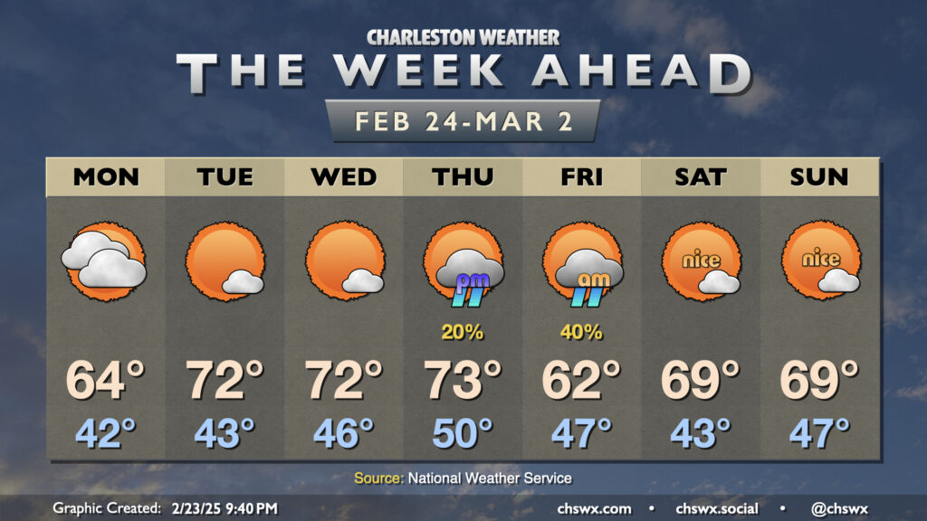
Climatological winter, which runs from December 1 to February 28 (or 29th, depending on the year) will end on a very spring-like note this week as temperatures head back above normal starting mid-week and beyond (with the exception of Friday, when a front comes by with a minor shot of cooler air).
First, though, we begin the week on a somewhat cloudy note as a storm system moves by to our south. Moisture won’t make it this far north, but high clouds will keep skies fairly well-covered and allowing temperatures only to about the mid-60s in the afternoon. These clouds will diminish for Tuesday, though, and temperatures respond nicely with 70s in the afternoon. We’ll keep this going through Thursday before the front swings by early Friday, bringing an evening shower chance to the area. We’ll keep shower chances in play overnight Thursday into Friday morning, but we should get much of Friday in rain-free (and slightly cooler as well with highs in the low 60s expected). We start March — and climatological spring — off on a nice note Saturday with lows in the low 40s warming to the upper 60s to around 70° under mostly sunny skies. We’ll do essentially the same thing Sunday, too.
Follow my Charleston Weather updates on Mastodon, Bluesky, Instagram, Facebook, or directly in a feed reader. Do you like what you see here? Please consider supporting my independent, hype-averse weather journalism and become a supporter on Patreon for a broader look at all things #chswx!