Friday & the weekend: Temperature rollercoaster ride with enhanced fire danger Saturday
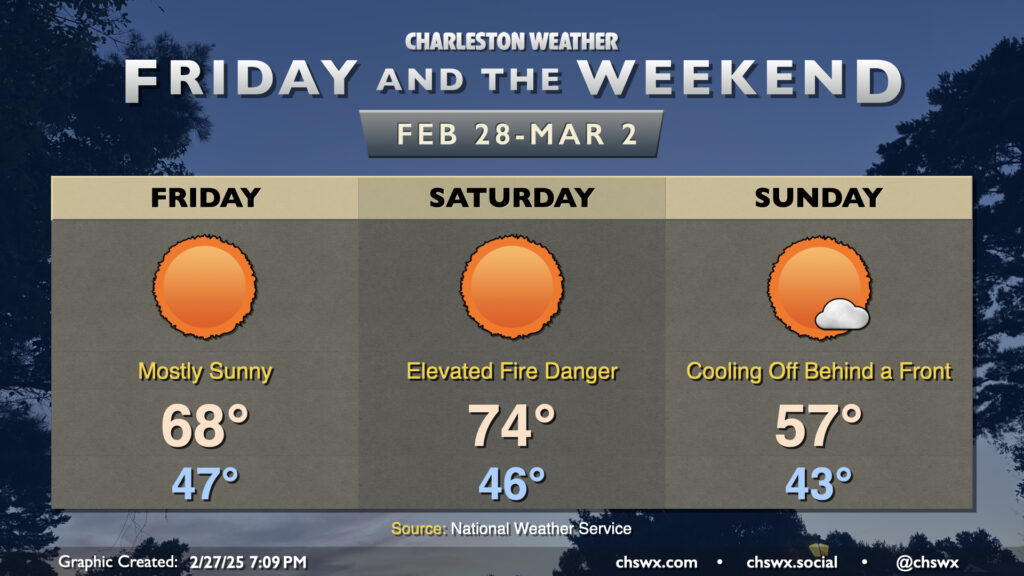
We’ll climb back aboard the temperature rollercoaster this weekend as a series of fronts affect the area. The first one, coming through Thursday night into early Friday, will knock temperatures down about 10° or so with highs in the upper 60s expected Friday afternoon with mostly sunny skies. This is just a click on the warm side of normal for February 28, which marks the end of climatological winter.
Saturday will run warmer ahead of another cold front as winds go back southwesterly. Lows in the mid-40s warm to the mid-70s in the afternoon, again with nearly unfettered sunshine. With the uptick in the wind and lower relative humidity, though, there will be an increased fire danger across the area. In fact, there was a wildfire of 75-100 acres over the past couple days in the Francis Marion National Forest, with some smaller fires going (a few of which are prescribed). So, we’ll need to be careful especially on Saturday and perhaps on Sunday depending on how winds and fuels shake out.
Sunday will turn much cooler as a backdoor front sinks south over the area. We should still get plenty of sunshine, but temperatures will peak in the mid-to-upper 50s in the afternoon after a low-40s start — well below normal for the beginning of March. Winds could remain elevated behind the front as well, so keep an ear out for possible Fire Danger Statements from the National Weather Service for Sunday, too, as a result.
Looking ahead: Next rain chance Wednesday could come with some thunderstorms
The next rain chance arrives on Wednesday as a potent storm system moves across the eastern half of the country. This should bring some widespread, much-needed rainfall to the area, but it may also bring some strong thunderstorms. The pattern is such that there’s enough confidence to place the area in a 15% risk of severe thunderstorms next Wednesday — pretty long lead time. We’ll see how this evolves, but for now, it’s just something to watch.
A word on National Weather Service layoffs
Finally, a quick word on reports of mass layoffs in NOAA and at the National Weather Service today. In short, it’s heartbreaking — the firing of probationary employees cuts down the best and brightest aspiring public servants as well as eliminates those who have been promoted in the past year or two. It’s an incredibly short-sighted move that not only hurts right now but will also be tough to recover from in the long run unless something magically gets reversed. This has impacts across the weather enterprise, from modeling to local forecasting and everything in between.
The National Weather Service is the backbone of the weather enterprise. The weather apps you use, the radar you check, the hurricane forecast you rely on, the weather warnings you receive when severe weather threatens — all of those things either don’t exist or work very differently without the National Weather Service. In having run @chswx for almost 17 years, I’ve gotten to know many of these folks who work long shifts day in, day out, and overnight to keep a weather watch over our community, and they’re nothing short of stellar public servants who are only in it to help their neighbors. While there’s no indication we’ve been impacted locally by these layoffs (yet), it’s still incredibly concerning and disturbing that these layoffs are even occurring. If you’re looking for government waste, simply put, it’s not here — $3/year out of your taxes is what it takes to run NWS. It is the best bang for your tax buck and deserves better than it is getting.
Follow my Charleston Weather updates on Mastodon, Bluesky, Instagram, Facebook, or directly in a feed reader. Do you like what you see here? Please consider supporting my independent, hype-averse weather journalism and become a supporter on Patreon for a broader look at all things #chswx!