Weekend forecast: Breezy with strong storms possible Sunday
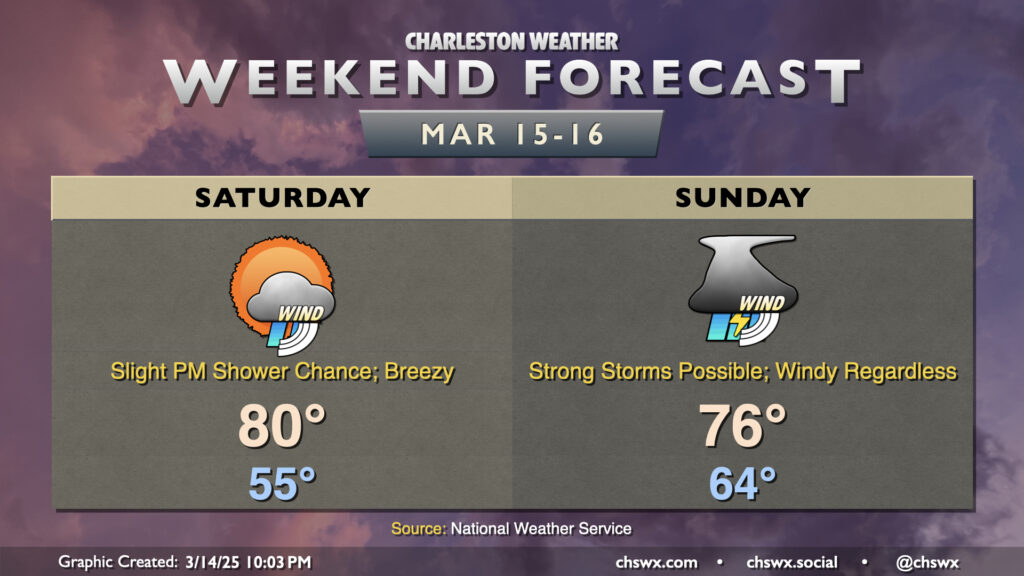
Breezy conditions continue this weekend ahead of a strong storm system that’s working its way across the midsection of the country over the next day or so, which could bring some strong storms to the area on Sunday.
Saturday looks mostly quiet and rain-free; a shower or two isn’t totally out of the question in the afternoon, but it’ll otherwise be a warm day with temperatures peaking around 80° in the afternoon under a mix of sun and clouds. Winds will start to kick up a bit during the day, with speeds 15-20 MPH possible with higher gusts.
We’ll keep these breezy conditions heading into Sunday as a squall line approaches the area. Even outside of thunderstorms, gusts pushing 35 MPH will be possible, and could even be a tick higher on bridges and overpasses. The main course will be the aforementioned squall line, which appears timed between mid-morning and mid-afternoon for the Lowcountry (though this timing is still a bit fuzzy and probably will be until the day of). The timing is important, though, because a later arrival may give the atmosphere more time to destabilize, which would increase the risk for severe weather. Alternatively, an earlier passage would still bring some severe risk, but the risk may not be quite as widespread. Regardless, we’ll need to be on guard for the risk for damaging wind gusts as the primary hazard, though the wind shear profiles are such that a tornado or two are not out of the question, either. Hail to quarter-size is a tertiary concern, but won’t be the main driver of the severe risk.
As I alluded to earlier, instability is — as usual — the governor on just how much of a risk we run of severe weather. Cool coastal waters often have something to say about how unstable we get, and cloud cover or even showers breaking out ahead of the line could tamp down on a more substantial threat as well. The other ingredients will be there, though, so we’ll still need to watch it closely. Make sure you have multiple ways to hear weather warnings Sunday, and know what to do in case a severe thunderstorm approaches your location.
Follow my Charleston Weather updates on Mastodon, Bluesky, Instagram, Facebook, or directly in a feed reader. Do you like what you see here? Please consider supporting my independent, hype-averse weather journalism and become a supporter on Patreon for a broader look at all things #chswx!