The week ahead: Temperature rollercoaster rolls on
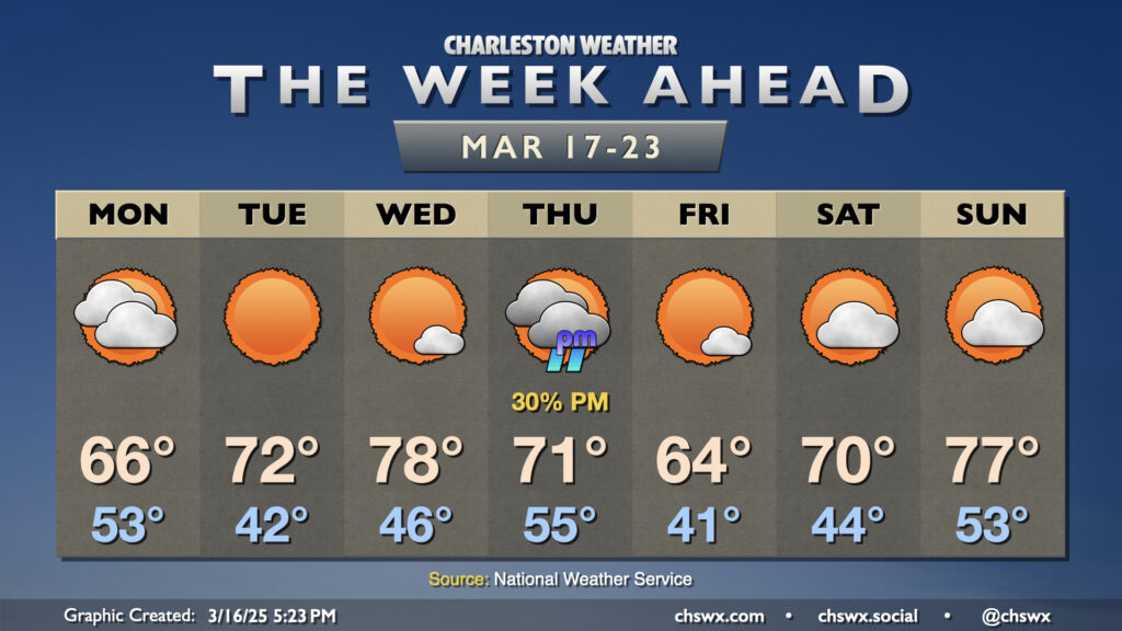
Up-and-down temperatures will be the main weather story this week, with the only shower chance coming later Thursday as another front moves by.
Monday starts the work week on a cool note as a chillier airmass continues to filter in behind the front that brought some thunderstorms to the area on Sunday. We start the day mostly cloudy and in the low-to-mid-50s, but those clouds will gradually thin out as the day goes on, and we should be clear by sunset. With the ongoing cool air advection, expect temperatures to peak in the mid-60s.
The below-normal cooldown doesn’t last long as we return to the low 70s on Tuesday, and on Wednesday, we can expect a rather pleasant weather day with lows in the mid-40s yielding to the upper 70s in the afternoon under mostly sunny skies.
The next front arrives Thursday. It won’t have quite as much moisture to work with, so an uptick in cloud cover with a few showers will be the primary concern. Temperatures start in the mid-50s, but warm to just the low 70s given the frontal passage. We turn even cooler Friday, with highs topping out in the mid-60s once again before the 70s return Saturday. Even better, it looks like we get a non-stormy Sunday in, too, with highs in the low 50s warming to the mid-to-upper 70s in the afternoon.
Follow my Charleston Weather updates on Mastodon, Bluesky, Instagram, Facebook, or directly in a feed reader. Do you like what you see here? Please consider supporting my independent, hype-averse weather journalism and become a supporter on Patreon for a broader look at all things #chswx!