Rest of the work week: Warmth peaking Wednesday, showers Thursday, cooler Friday
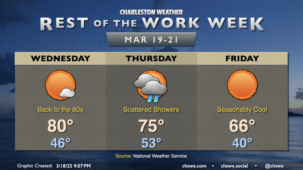
Warmth will peak Wednesday as high pressure slips offshore, sending winds back around to the south and highs up to around 80° in the afternoon under mostly sunny skies. We’ll see a few more clouds move in late as a cold front draws closer to the area, but Wednesday will remain rain-free.
We won’t be able to say the same about Thursday as the front comes through, though. Expect cloud cover to start the first day of astronomical Spring, with showers arriving in the afternoon ahead of said front. Fortunately, it’s all good stuff — we could still use the rain (though don’t count on much), and there won’t be any risk for severe weather coming along for the ride, either. Temperatures on Thursday start in the low 50s, warming to the mid-70s in the afternoon ahead of the rain.
Friday turns much cooler in the wake of the front. We’ll start the day around 40°, warming to just the mid-60s in the afternoon — seasonably cool for this point in the year. It’ll be bright and sunny, though, which will make it feel pretty nice outside.
Expect temperatures to warm back to the 70s each afternoon this weekend, with generally quiet weather expected (welcome news for those of you who haven’t been fans of our recent stormy Sundays). The next rain chance arrives Monday.
Follow my Charleston Weather updates on Mastodon, Bluesky, Instagram, Facebook, or directly in a feed reader. Do you like what you see here? Please consider supporting my independent, hype-averse weather journalism and become a supporter on Patreon for a broader look at all things #chswx!