The week ahead: Stormy Monday, then turning more seasonable
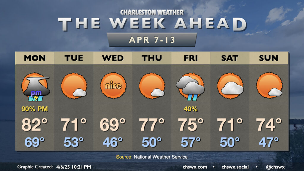
The recent late spring/early summer preview of the past week or so will come to an end on Monday as a cold front moves through the area, bringing more seasonable (if not somewhat cooler-than-normal) temperatures back to the Lowcountry for the second week of April.
We’ll start Monday with lows near 70° one more time as temperatures head back to the low 80s in the afternoon ahead of a round of showers and thunderstorms that will accompany the front. At a minimum, we’ll get the first part of the day in rain-free, with shower and thunderstorm chances increasing as we head into the afternoon and especially the early evening. There’s a decent chance that we could see some heavy downpours around the commute, and some ponding of water could take place as a result, so be careful for that.
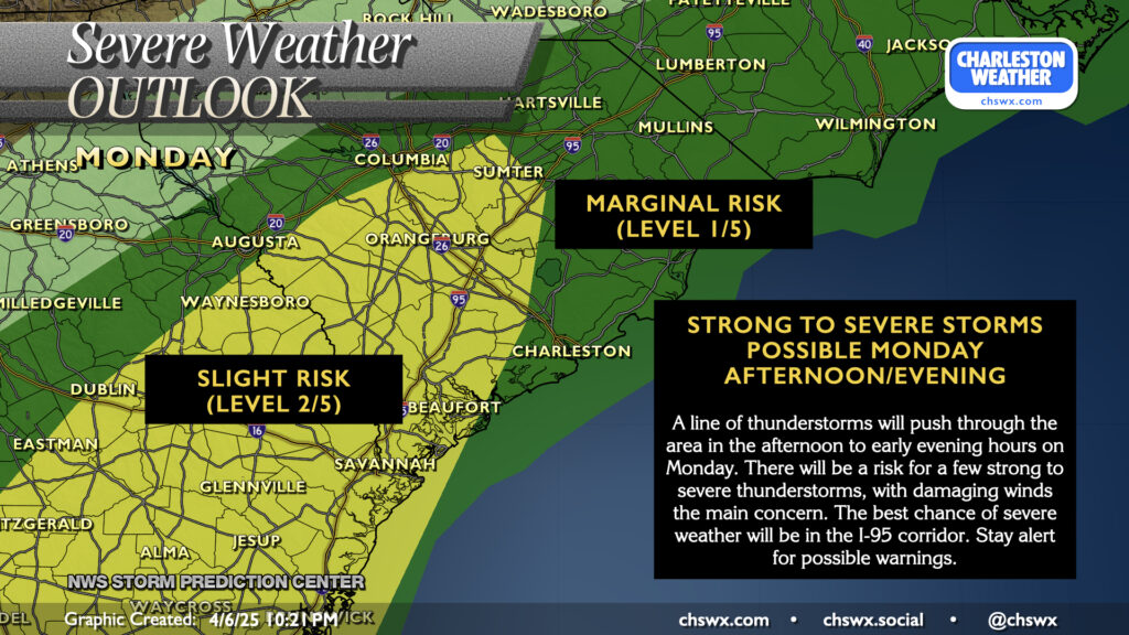
A few of us may also contend with some stronger and maybe even sporadically severe thunderstorms; modest instability is expected to develop in the afternoon ahead of the band of storms, and with decent shear, a few storms could produce damaging winds, particularly in the I-95 corridor. As is typical, expect instability to decrease getting closer to the coast and the Atlantic shelf waters, which should limit — though not totally shut off — the risk for severe weather as you get into Charleston proper. So, keep an eye to the weather tomorrow afternoon as you prepare to commute and be ready to allow for some extra time to get home.
The front will get through late into the overnight on Monday, and by Tuesday morning, clouds will be scouring out and temperatures will be running quite a bit cooler — expect lows in the low-to-mid-50s to start the day, a change from the pace of record warm low temperatures we’ve endured in recent days. Temperatures Tuesday only top out in the low 70s. We may not even make the 70s on Wednesday as high pressure moves by to the north. Temperatures start to moderate on Thursday as the high slips into the Atlantic ahead of the next front, which right now looks to bring some shower chances for Friday before high pressure builds back in for the weekend. Temperatures will remain generally pleasant, right around if not a tick or two below normal at times.
Follow my Charleston Weather updates on Mastodon, Bluesky, Instagram, Facebook, or directly in a feed reader. Do you like what you see here? Please consider supporting my independent, hype-averse weather journalism and become a supporter on Patreon for a broader look at all things #chswx!