The week ahead: 80s to start and close the week, with a couple cooler days sandwiched in
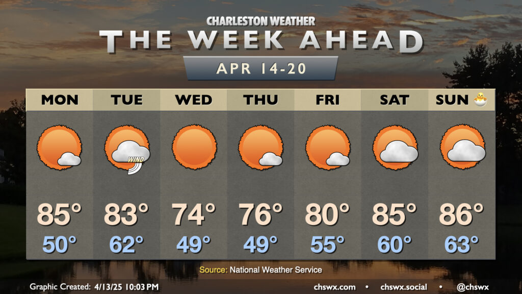
A generally quiet and warm week of weather (with a brief cooldown in the middle) lies ahead as we approach Easter, well-timed for spring break for Berkeley and Charleston’s school districts.
After a gorgeous and somewhat seasonably cool Sunday (highs only topped out around 70°), high pressure slips offshore and turns the low-level flow more southerly, which will in turn send temperatures back to the mid-80s after a start around 50°. We can expect some breezy conditions as the high departs, with gusts 20-25 MPH possible at times.
A cold front approaches Tuesday, but without much in the way of deep moisture, all it’ll squeeze out is a little bit more in the way of cloud cover than we’ll see on Monday. It’ll be a much warmer start as lows bottom out in the low 60s; we’ll warm back to the low to mid-80s in the afternoon. Expect even breezier conditions on Tuesday, with some guidance suggesting gusts approaching 30-35 MPH at times ahead of the front.
Wednesday and Thursday will be the coolest days of the week, with temperatures peeking just a couple clicks below mid-April normals. There will be plenty of sunshine and not much in the way of humidity to speak of, so it should feel pretty great outside as surface high pressure builds in. A more pronounced warming trend returns for Friday into the weekend as high pressure slides offshore, with highs getting back into the mid-80s just in time for Easter Sunday.
Follow my Charleston Weather updates on Mastodon, Bluesky, Instagram, Facebook, or directly in a feed reader. Do you like what you see here? Please consider supporting my independent, hype-averse weather journalism and become a supporter on Patreon for a broader look at all things #chswx!