The week ahead: Pleasantly warm for much of the week; next storm chance Friday
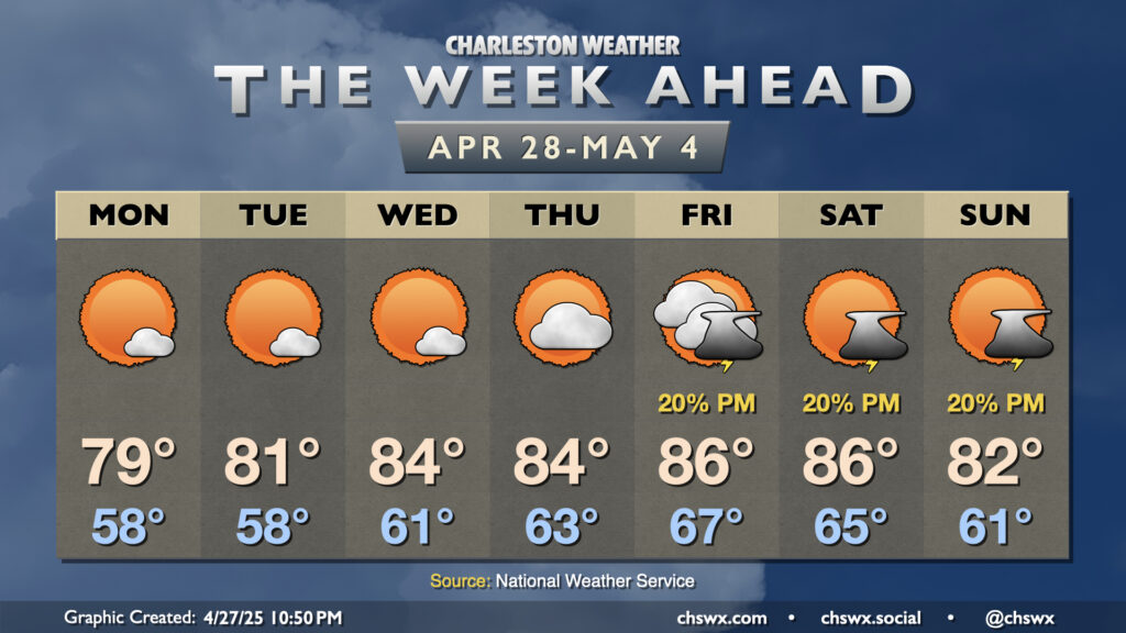
High pressure will be the main weather feature for the next few days, with comfortable warmth and plenty of sunshine expected through Thursday before the next isolated storm chance arrives Friday.
We’ll start the week with temperatures near normal as high pressure continues to ridge southward across the area. Lows on Monday and Tuesday start in the upper 50s (with low-to-mid-60s near the coast), and highs will peak generally in the upper 70s to around 80°. A few clouds will be possible from time to time amongst otherwise unencumbered sunshine.
Surface high pressure starts to slip offshore by mid-week, and that will kick off a bit more of a warming trend as highs will peak in the mid-80s on Wednesday and Thursday, while lows steadily climb into the low-to-mid-60s. Partly cloudy to mostly sunny skies will persist, though.
A trough of low pressure aloft begins to affect the area on Friday as high pressure slips further offshore, and with it comes a bit of a better chance of an afternoon thunderstorm or two. Temperatures will warm into the mid-to-upper 80s from very mild mid-to-upper 60s across much of the area in the morning. Saturday will look a lot like Friday did, albeit perhaps with some additional storm coverage as we get into the later evening and overnight hours as a cold front approaches. The front moves by overnight Saturday into Sunday, and cools us off a little bit as a result, but a thunderstorm or two may still be in the cards as the seabreeze pushes inland.
Coastal flooding threat for Monday and Tuesday evenings
Favorable northeast winds and the upcoming new moon combined to drive tidal water levels into flood stage for the first time in 2025 on Sunday evening, with a maximum tide of 7.82′ mean lower low water recorded in Charleston Harbor at 8:36 PM. This produced moderate flooding that closed several roads including the Highway 61 offramp from Highway 17 in West Ashley.
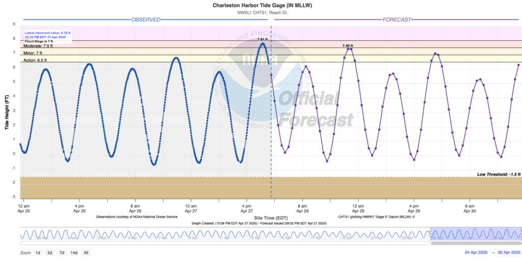
Coastal flooding will be a problem again Monday and Tuesday evenings, though not quite to the extent that it ended up being on Sunday evening. Minor to moderate flooding is once again possible Monday, while generally minor flooding is expected Tuesday before winds turn a bit more unfavorable for coastal flooding by Wednesday (though it may be close). Keep an ear out for Coastal Flood Advisories from the National Weather Service as they will be your signal for when salt water could inundate and close roads. Remember, this is salt water, and it is absolutely terrible for your car. Never cross a flooded road!
Follow my Charleston Weather updates on Mastodon, Bluesky, Instagram, Facebook, or directly in a feed reader. Do you like what you see here? Please consider supporting my independent, hype-averse weather journalism and become a supporter on Patreon for a broader look at all things #chswx!