Rest of the work week: Generally quiet weather continues with a little more warmth
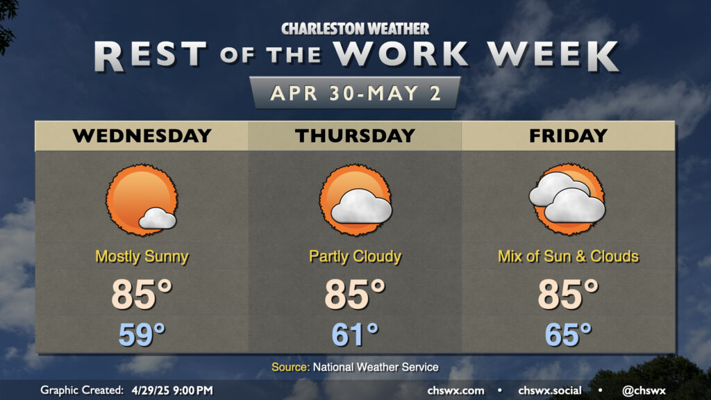
High pressure moving offshore will help send winds a little more southerly for the rest of the work week, and temperatures will respond with a subtle bump into the mid-80s each afternoon. Expect mostly sunny skies to prevail on Wednesday; lows in the upper 50s warm to about 85° in the afternoon, except a little cooler near the coast where the cooler Atlantic waters will modulate the high temperatures a bit.
Thursday should largely be a carbon copy of Wednesday, albeit with a slightly warmer start (low 60s instead of upper 50s). A few more clouds will be possible as well, but sunshine still appears to be the predominant feature in our skies. Once again, temperatures climb to the mid-80s in the afternoon.
Signs of changes begin on Friday as a few more clouds enter the picture ahead of an approaching front and upper trough. We’ll start a bit warmer than Thursday, with lows in the mid-60s; highs will still top out around 85° owing to some of the cloud cover that will be building in. Rain should hold off for much of the day, but a stray shower or storm may not be totally out of the question later in the evening.
The best rain chances arrive Saturday afternoon through Sunday morning as the front gets by. Showers and a few thunderstorms appear possible, though the risk for any severe weather seems low. Highs on Saturday top out in the mid-80s, while Sunday we’ll run a little cooler in the wake of the front, with highs only peaking around 80°. Largely quiet and seasonable weather kicks off the first work week of May, though a stray shower is possible Monday afternoon.
Follow my Charleston Weather updates on Mastodon, Bluesky, Instagram, Facebook, or directly in a feed reader. Do you like what you see here? Please consider supporting my independent, hype-averse weather journalism and become a supporter on Patreon for a broader look at all things #chswx!