The week ahead: Stormy start, then turning quite summer-like
A pesky mid-level low will continue to keep scattered to numerous showers and thunderstorms in the forecast for the first part of the upcoming week. From there, high pressure returns and sends us right into summer to close the week.
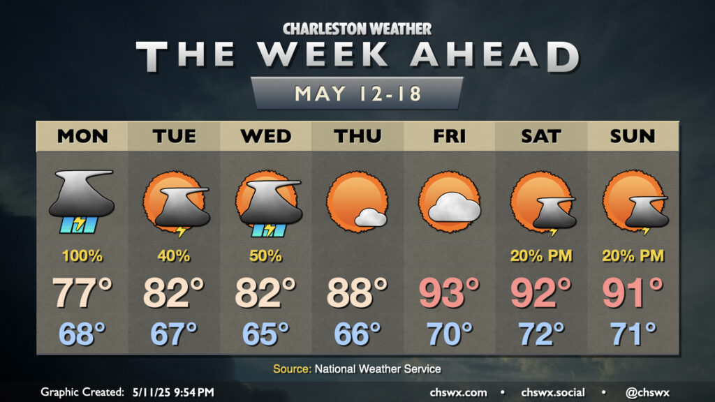
After record rainfall fell on Sunday, showers and thunderstorms will continue for much of Monday as a cut-off mid-level low continues to lumber across the Deep South and a stalled front lingers across the area. Several rounds of heavy rain appear possible, with a low-end risk for a severe thunderstorm with gusty winds and maybe a tornado coming along for the ride. The deeply moist airmass will keep lows in the upper 60s, while warming to the mid-to-upper 70s will largely be governed by showers and thunderstorms. It’s tough to pinpoint exact times when it may or may not be raining at any one location, so the goal for Monday is to remain prepared for rain throughout the day, including around the commutes. Additional flooding may be possible at times, so be sure you’re minding where you park your car downtown just in case.
The pattern begins to dislodge a bit on Tuesday as the mid-level low moves into the Carolinas, pushing a surface cold front through the area. As a result, we’ll see the deep plume of moisture begin to move to our northeast. However, we’ll still have enough moisture and instability to promote scattered showers and thunderstorms Tuesday and Wednesday afternoons as the mid-level feature works across the area, gradually weakening and opening up into a wave as it moves through. Temperatures will peak in the low 80s each afternoon as shower and thunderstorm activity should still act as a governor on getting too much warmer.
High pressure starts to take over on Thursday, and this comes with a noticeable uptick in temperatures: upper 80s Thursday afternoon become low-to-mid-90s on Friday. Dewpoints in the upper 60s to low 70s could drive heat indices near or over 100° as well, especially as we get into the weekend. Showers and thunderstorms aren’t expected Thursday and Friday with high pressure firmly in control. Some energy aloft could move by Saturday into Sunday, promoting some isolated storms generally along and ahead of the seabreeze, but most of us should stay rain-free as we get into the warmest stretch thus far in 2025.
Follow my Charleston Weather updates on Mastodon, Bluesky, Instagram, Facebook, or directly in a feed reader. Do you like what you see here? Please consider supporting my independent, hype-averse weather journalism and become a supporter on Patreon for a broader look at all things #chswx!