Rest of the work week: Active pattern continues
The active pattern that’s kept things on the stormy side the past few days will continue until a front sweeps through the area late Friday, clearing things up a bit for the weekend. For now, though, we’re still going to be dodging scattered to numerous showers and thunderstorms each afternoon.
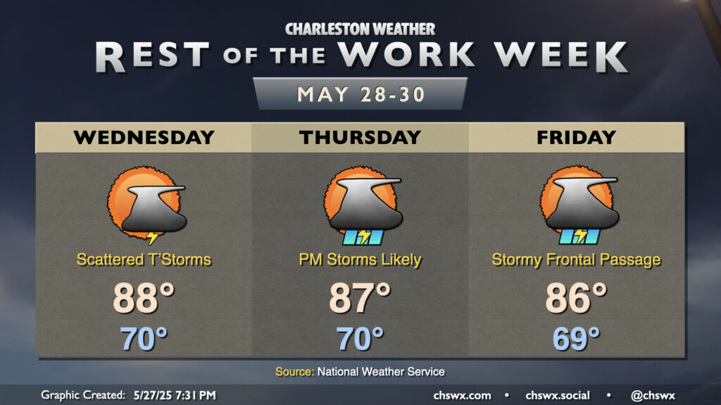
Wednesday may represent a small down-trend in storm coverage over previous days as the stalled front that’s been draped across SC lifts north and away. Still, the seabreeze should kick up a scattering of afternoon thunderstorms with some pockets of heavy rain and lightning. We’ll start the day around 70°, warming to the upper 80s in the afternoon before storms start to fire.
More vigorous energy moves across the area on Thursday, though, and this combined with the seabreeze as well as any remnant outflow boundaries from the day before should help kick up scattered to numerous thunderstorms in the afternoon and evening hours. The risk for severe weather is low, but non-zero as the energy aloft interacts with the warm and humid airmass. Once again, expect highs to top out in the upper 80s after we start around 70°.
A cold front will approach the area on Friday, and a line of thunderstorms should accompany it as we get into the late afternoon and evening hours. Shear and instability will be a bit more favorable for severe weather ahead of the front, so we’ll want to keep an eye on the risk for damaging straight-line wind gusts. Highs peak in the mid-80s in the afternoon out ahead of the front.
Thankfully, the front passes by overnight Friday, and sets us up for a quiet and reasonably comfortable weekend of weather. Just a few more days!
Follow my Charleston Weather updates on Mastodon, Bluesky, Instagram, Facebook, or directly in a feed reader. Do you like what you see here? Please consider supporting my independent, hype-averse weather journalism and become a supporter on Patreon for a broader look at all things #chswx!